


Inclusion Thresholds - Hazard Services
Inclusion Thresholds
Purpose:
This jobsheet will walk the Focal Point through configuring the inclusion thresholds for Short Fuse hazards in Hazard Services.Tasks:
AT-A-GLANCE:
- What? Perform incremental overrides of inclusionAndOr, inclusionFraction, inclusionAreaInSqKm, and inclusionThresholdWarning for hazard types within HazardTypes.py to set inclusion thresholds.
- More customizable. In WarnGen, overrides can only be set by hazard category (county, marine, or zone). Within Hazard Services, overrides are set by hazard type, so different hazard types of the same category can have different inclusion thresholds.
- Compare with other WFOs. For more information about how inclusion thresholds work, including a table showing what inclusion area and fraction values are currently used in WarnGen by each WFO, click here. By comparing with other WFOs by region or county size, you can consider whether you want to transfer your current WarnGen settings to Hazard Services or try settings used by similar offices.
Follow the steps below for more detailed guidance.
-
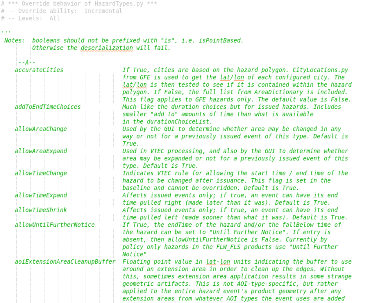
In the Localization perspective navigate to Hazard Services –> Hazard Types –> HazardTypes.py and double click on BASE. Take note of the inline documentation of the available keys within each hazard type, especially the inclusion keys.
-
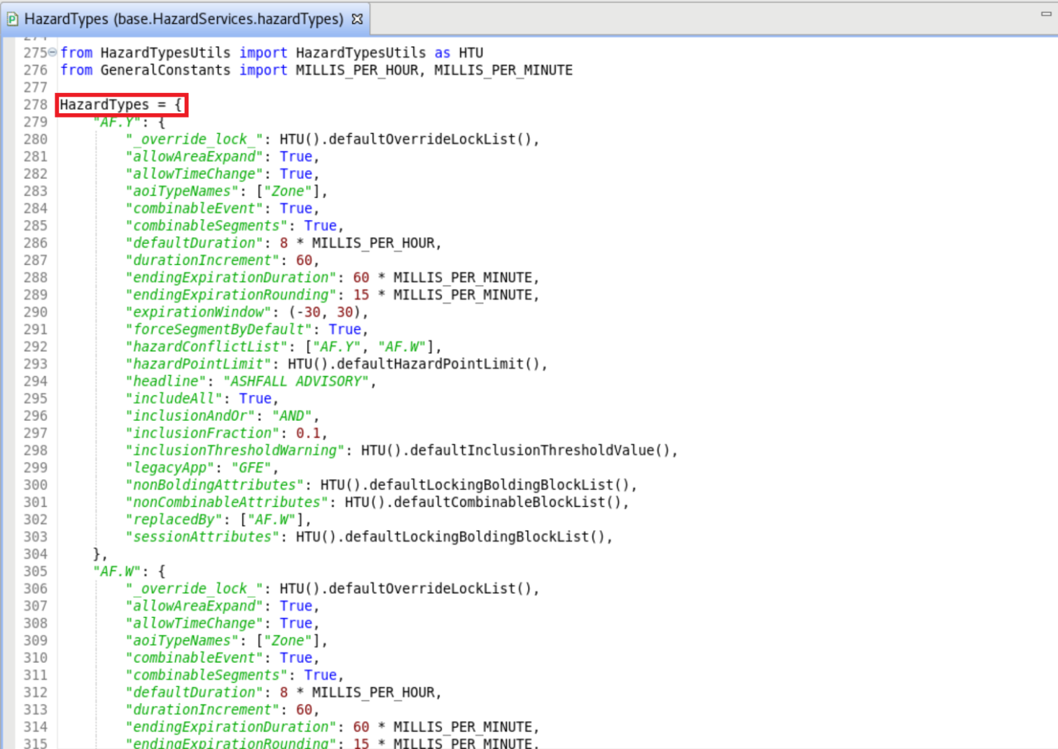
Scroll past the documentation and identify the parent dictionary HazardTypes. Each hazard has its own dictionary nested within HazardTypes.
-
If there isn't currently a USER override file then right click BASE –> Create Override File and select User.
-
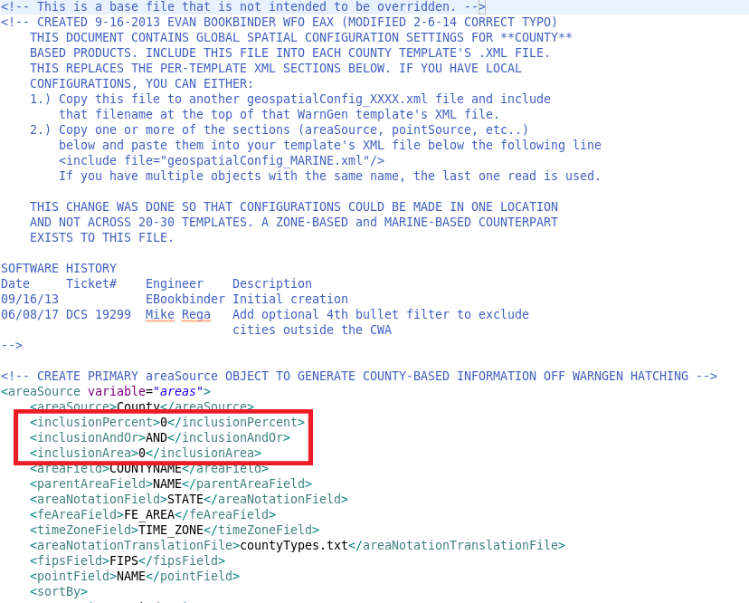
From the Localization perspective, navigate to D2D –> WarnGen –> geospatialConfig_COUNTY.xml –> SITE and double click on SITE to load. Under the geospatialConfig_COUNTY.xml's <areaSource variable="areas"> tag identify your <inclusionPercent>, <inclusionAndOr>, and <inclusionArea> tags.
*NOTE: If overriding marine Short Fuse hazards (MA.W and MA.S), the WarnGen inclusion settings and overrides can be found in D2D –> WarnGen –> geospatialConfig_MARINE.xml. If overriding zone Short Fuse hazards (SP.S), WarnGen inclusion settings and overrides can be found in D2D –> WarnGen –> geospatialConfig_ZONE.xml. -
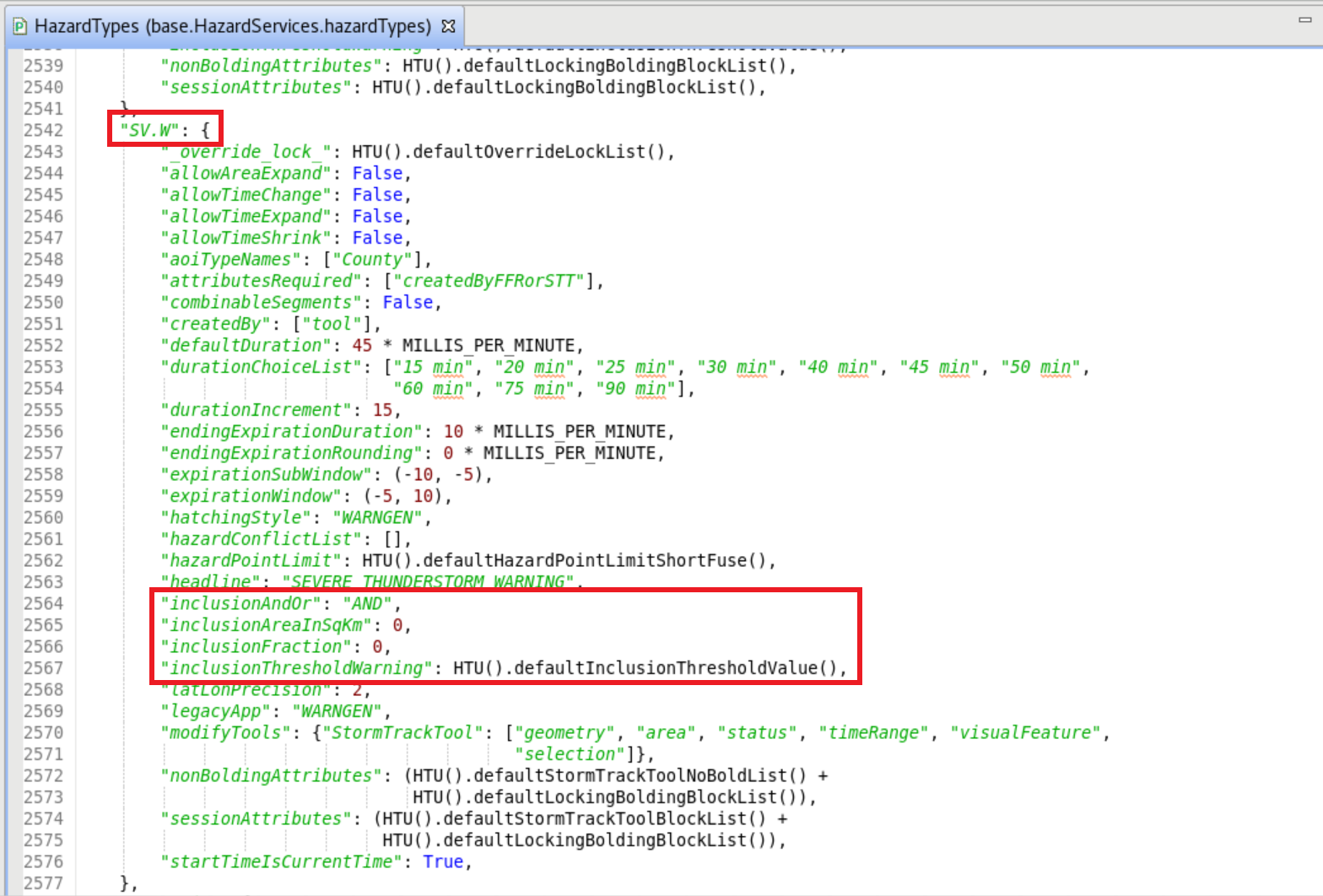
Identify the SV.W dictionary in the BASE file and take note of the inclusion keys. The default value for inclusionFraction and inclusionAreaInSqKm is 0.
-
Populate the USER file by first adding the HazardTypes dictionary and then embedding the SV.W dictionary. Copy and paste the key:value pairs from the SV.W dictionary that control the county inclusion thresholds. Change inclusionAndOr, inclusionFraction, and inclusionAreaInSqKm to reflect the configuration values in your WarnGen SITE override. Changing inclusionThresholdWarning to True will give you more informative messages from AlertViz for troubleshooting. The Hazard Services USER override should look like this:
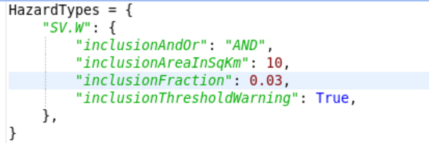
*NOTE: The value for inclusionFraction MUST be a number between 0.00 and 1.00. -
To configure the inclusion thresholds for other hazard types, embed the given hazard type's dictionary within HazardTypes as demonstrated using SV.W above. The other Short Fuse hazards you may wish to add inclusion threshold overrides for are: Tornado Warning (TO.W), Dust Storm Warning (DS.W), Dust Advisory (DS.Y), Snow Squall Warning (SQ.W), Extreme Wind Warning (EW.W) (if enabled), Marine Weather Statement (MA.S), Special Marine Warning (MA.W), Aviation Weather Warning (AW.W), and Special Weather Statement (SP.S).
-
Save the USER override file by type Ctrl+S.
-
If this is the first time setting up the user override, a File Version Conflict message will appear. Choose OK.
-
Click X on the merge tab that appears.
-
Choose Save on the dialog box that appears.
-
Choose Replace editor content on the dialog box that appears.
-
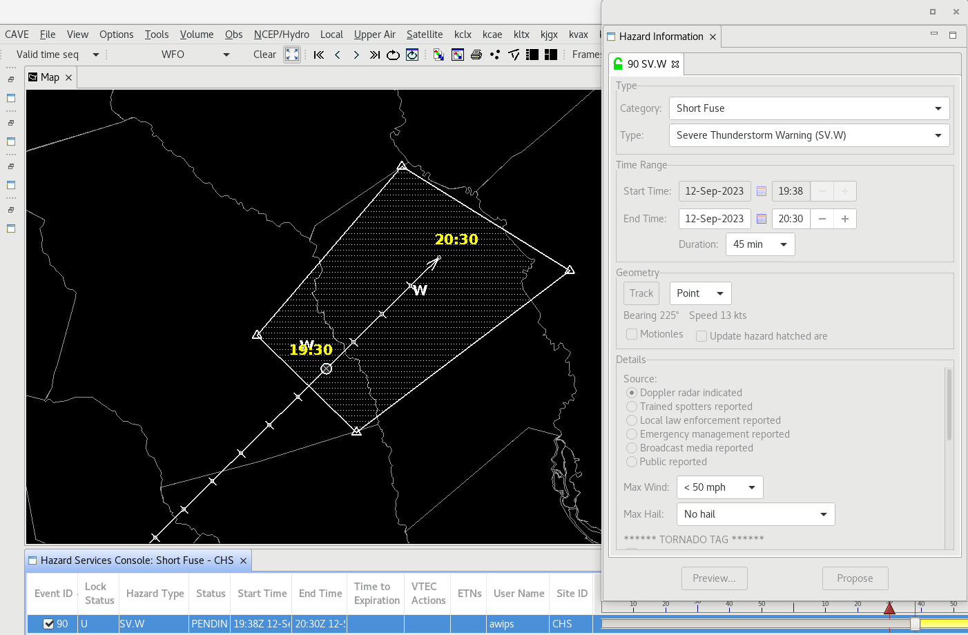
To test your new inclusion thresholds, open the D2D perspective and launch the Storm Track Tool. Begin editing a SV.W and drag a polygon vertex until the hatching disappears from the county to be excluded (top image). Drag the vertex away again and the portion of the county within the polygon will be hatched (bottom image).

-
Test the inclusion thresholds for each of the hazard types you overrode. When you are comfortable that the USER overrides are working as you want, return to the Localization perspective. Promote the USER override to a SITE override by right-clicking USER under HazardTypes.py in the File Browser and selecting Copy To –> Site.
Congratulations, you've configured the county inclusion threshold for a hazard type.