


Zone Based Inclusion Reference Page - Hazard Services
Zone-Based Inclusion Reference Page
Purpose
This is a page containing the WarnGen and Hazard Services Zone based inclusion fraction, used for products such as special weather statements (SPS), for all CWAs that focal points can use to explore in order to decide how or if to modify their office's values when transitioning to Hazard Services Convective.
If you have questions or feedback about this table you can contact the AWIPS team via email: nws.wdtd.awips@noaa.gov
What Is A Zone Inclusion Fraction?
This is a value (either in % of zone area and/or square kilometers of zone area) that determines the amount of space a polygon needs to cover in order to trigger hatching and include the zone in the product. The zone-based inclusion fraction is similar to the county-based inclusion fraction described here.
Changing Your Zone Inclusion Fraction in WarnGen
In WarnGen, the Zone areaSource tag, within the geospatialConfig_ZONE.xml file, is used to adjust inclusion fraction and area values. WarnGen uses integer values for inclusion fraction percentages (e.g. 1 is 1%).
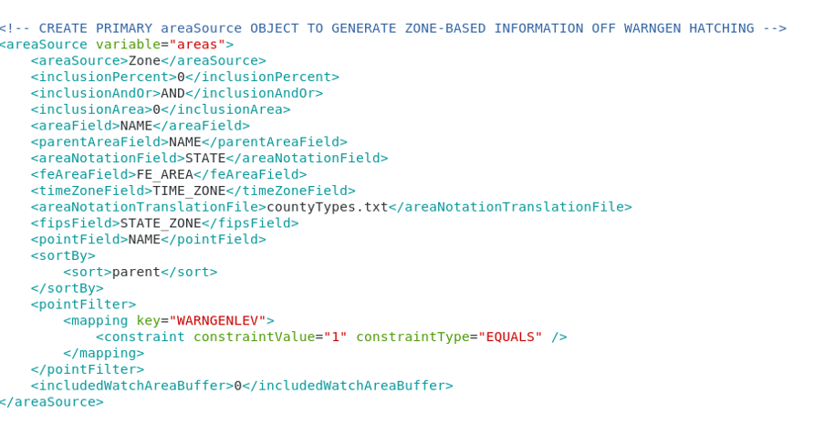
Edit the appropriate values (inclusionPercent, inclusionAndOr, and inclusionArea) to adjust your settings.
Changing Your Zone Inclusion Fraction in Hazard Services
In Hazard Services, zone-based inclusion fractions and county-based inclusion fractions are specified in the HazardTypes.py file using incremental overrides for the specific hazard types. Hazard Services uses decimal values for inclusion fraction percentages (e.g. 0.01 is 1%). See this jobsheet on creating and editing an override file.
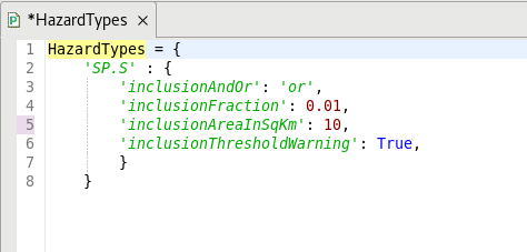
Edit the appropriate values (inclusionFraction, inclusionAndOr, and inclusionAreaInSqKm) to adjust your settings.
Zone Inclusion Fractions Across The NWS
16 sites do not have the settings for Zone Inclusion Fractions configured: CYS, DVN, EKA, EPZ, GGW, GUM, HNX, ILX, LKM, MSO, PUB, SGX, SJU, STO, TFX, and VEF.
22 sites use the default settings of 0% AND 0 sq km.
The majority of sites have percentage inclusion values ranging from 1-5% with varying use of AND/OR and a range of area inclusion values. 45 sites have set their area inclusion to 0 sq km while 28 sites have values greater than or equal to 20 sq km.