


Locations Affected (List of Cities/Pathcast) - Hazard Services
Locations Affected (List of Cities/Pathcast)
Purpose:
This jobsheet will walk the Focal Point through configuring the List of Cities and Pathcast in the Locations Affected text field when using the Storm Track Tool in Hazard Services.Tasks:
AT-A-GLANCE:
-
What? Perform an incremental override of "LocationsAffected" within SpatialQueryConfigs.py to change List of Cities settings. Perform an incremental override of PathcastConfig.py to change Pathcast settings.
-
Why? The Locations Affected field in the public hazard product includes information about locations under threat. The List of Cities option provides a list of locations within the hazard polygon, while the Pathcast option provides more detailed information about the hazard's expected time of arrival at locations under threat. Customizing the Locations Affected field allows you to control the specificity of the information you provide partners and the public.
-
Current WarnGen settings. Your current WarnGen geospatial settings can be found in the Localization perspective by navigating to D2D –> Warngen. You can find settings for county hazards in geospatialConfig_COUNTY.xml, settings for marine hazards in geospatialConfig_MARINE.xml, and settings for zone hazards in geospatialConfig_ZONE.xml. This jobsheet will focus on county hazards, but the process for marine or zone hazards will be the same.
Follow the steps below for more detailed guidance.
SECTIONS
1. Locations Affected: List of Cities
*NOTE: In WarnGen only cities that are within a certain distance from the track line (the value of <distanceThreshold> within “cityList” in geospatialConfig_COUNTY.xml) appear in the text List of Cities. This threshold requirement for “List of Cities” is removed in Hazard Services, so cities that are anywhere within the polygon can be listed, subject to the “maxResults” and sorting constraints.
-
To see your current WarnGen Locations Affected settings, in the Localization perspective navigate to D2D –> Warngen –> geospatialConfig_COUNTY.xml and double click on SITE to load your overrides.
-
Navigate to Hazard Services –> GeoSpatial Config –> SpatialQueryConfigs.py and double click on BASE to load.
-
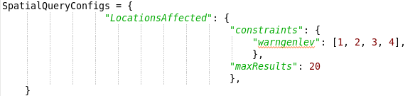
The WarnGen List of Cities settings are found within geospatialConfig_COUNTY.xml as “cityList”, and the Hazard Services List of Cities settings are contained as “LocationsAffected” within the SpatialQueryConfigs dictionary. There’s a one-to-one relationship between the WarnGen and Hazard Services settings, making it simple to take your WarnGen overrides and map them to corresponding Hazard Services overrides.
-
Some of the main things you can control in “LocationsAffected” within SpatialQueryConfigs.py are the WarnGen levels, land/water parameters, and the maximum number of cities that appear in the Locations Affected text.
-
WarnGen levels are set by “warngenlev” within the “constraints” dictionary. The default values are 1, 2, 3, 4.
-
Land/water parameters are set by “landwater” within the “constraints” dictionary. The default values are “L”, “LW”, “LC”.
-
Maximum number of cities is set by “maxResults”. The default value is 20.
-
-
To override any of these values, create a USER override for SpatialQueryConfigs.py (if one does not already exist) by right-clicking BASE –> Create Override File and selecting User. Open the USER override file.
-
Copy the SpatialQueryConfigs dictionary into your USER override file containing the keys you wish to override based on your current WarnGen overrides.
-
Change the values of each key to match your WarnGen override values.
-
Save the override file using Ctrl+S. Merge if it asks you to.
-
Test your new settings in the D2D perspective using the Storm Track Tool. When you are comfortable that the USER override is working as you want, return to the Localization perspective. Promote the USER override to a SITE override by right-clicking USER under SpatialQueryConfigs.py in the File Browser and selecting Copy To –> Site.
*NOTE: There is no simple override that will allow you to have different SpatialQueryConfigs for different hazard types or categories.
2. Locations Affected: Pathcast
-
In the Localization perspective navigate to Hazard Services –> GeoSpatial Config –> PathcastConfig.py and double click on BASE to load.
-
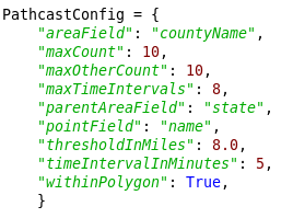
The WarnGen Pathcast settings are found within geospatialConfig_COUNTY.xml and the corresponding Hazard Services settings are in PathcastConfig.py. There’s a one-to-one relationship between the WarnGen and Hazard Services settings, making it simple to take your WarnGen overrides and map them to corresponding Hazard Services overrides.
-
There are a variety of keys within the PathcastConfig dictionary that you can override to configure the Pathcast. These should be most useful:
-
“maxCount”: the maximum number of locations listed at a single time step interval. The default value is 10. WarnGen setting in <pathcastConfig> as <maxResults>.
-
“maxOtherCount”: the maximum number of locations listed in the “Other locations impacted by” part of the text. The default value is 10. WarnGen setting in <pointSource variable="otherPoints"> as <maxResults>.
-
“maxTimeIntervals”: the maximum number of timesteps to show in the Pathcast. The default value is 8. WarnGen setting in <pathcastConfig> as <maxGroup>.
-
“thresholdInMiles”: the maximum number of miles a location can be from the interpolated Pathcast in order to be included in the text. The default value is 8.0 miles. WarnGen setting in <pathcastConfig> as <distanceThreshold> (note that WarnGen defaults to 4.0 miles for Pathcast cities and 10 miles for “other locations”).
-
“timeIntervalInMinutes”: the time gap between each Pathcast check. The default value is 5 minutes. WarnGen setting in <pathcastConfig> as <interval>.
-
“withinPolygon”: a boolean value that determines whether a location must be within the hazard event polygon to be listed in the Pathcast (value True) or if a location can be listed that falls outside the polygon but still within the “thresholdInMiles” distance (value False). The default value is True. WarnGen setting in <pathcastConfig> as <withinPolygon>
*NOTE: The maximum duration of the Pathcast can be found by multiplying “maxTimeIntervals” by “timeIntervalInMinutes”. So by default, the Pathcast will go for 40 minutes (8 × 5).
-
-
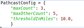
To override any of these values, create a USER override for PathcastConfig.py (if one does not already exist) by right-clicking BASE –> Create Override File and selecting User. Open the USER override file.
-
In the USER override file, enter the PathcastConfig dictionary containing the keys you wish to override and set their values to match the settings in your WarnGen override file.
-
Save the override file using Ctrl+S. Merge if it asks you to.
-
Test your new settings in the D2D perspective using the Storm Track Tool. When you are comfortable that the USER override is working as you want, return to the Localization perspective. Promote the USER override to a SITE override by right-clicking USER under PathcastConfig.py in the File Browser and selecting Copy To –> Site.
-
Similar to the List of Cities settings in the first section above, you can also find Pathcast settings for WarnGen levels and land/water parameters in SpatialQueryConfigs.py. The WarnGen Pathcast settings are found in geospatialConfig_COUNTY.xml within <pathcastConfig> and <pointSource variable="otherPoints">, and the corresponding Hazard Services Pathcast settings are contained in “PathcastPoints” and “PathcastOtherPoints” within the SpatialQueryConfigs dictionary. There’s a one-to-one relationship between the WarnGen and Hazard Services settings, making it simple to take your WarnGen overrides and map them to corresponding Hazard Services overrides.
Congratulations, you've configured the Locations Affected field when using the Storm Track Tool.