| 23.2.2 |
2024/12 |
Winter |
- Winter turnkey one pager of changes made to Hazard Services for NPW and Winter and supporting turnkey documentation
- Freeze Watch/Warning replaces Hard Freeze Watch/Warning
- Extreme Cold Watch/Warning replaces Wind Chill Watch/Warning
- Cold Weather Advisory replaces Wind Chill Advisory
- Temperature/Wind radio button in HID informs the "What Bullet" with "Very cold temperatures" or "Very cold wind chills"
|
| 23.2.2 |
2024/12 |
NPW |
- All new hazards are within the NPW hazard type
|
| 23.2.2 |
2024/12 |
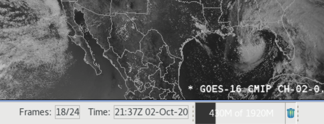
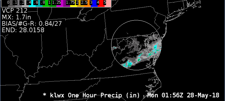
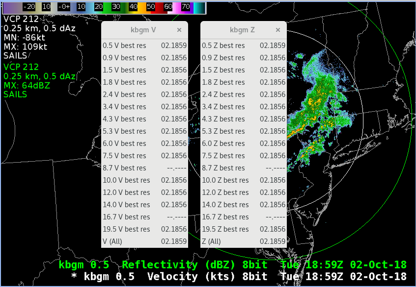
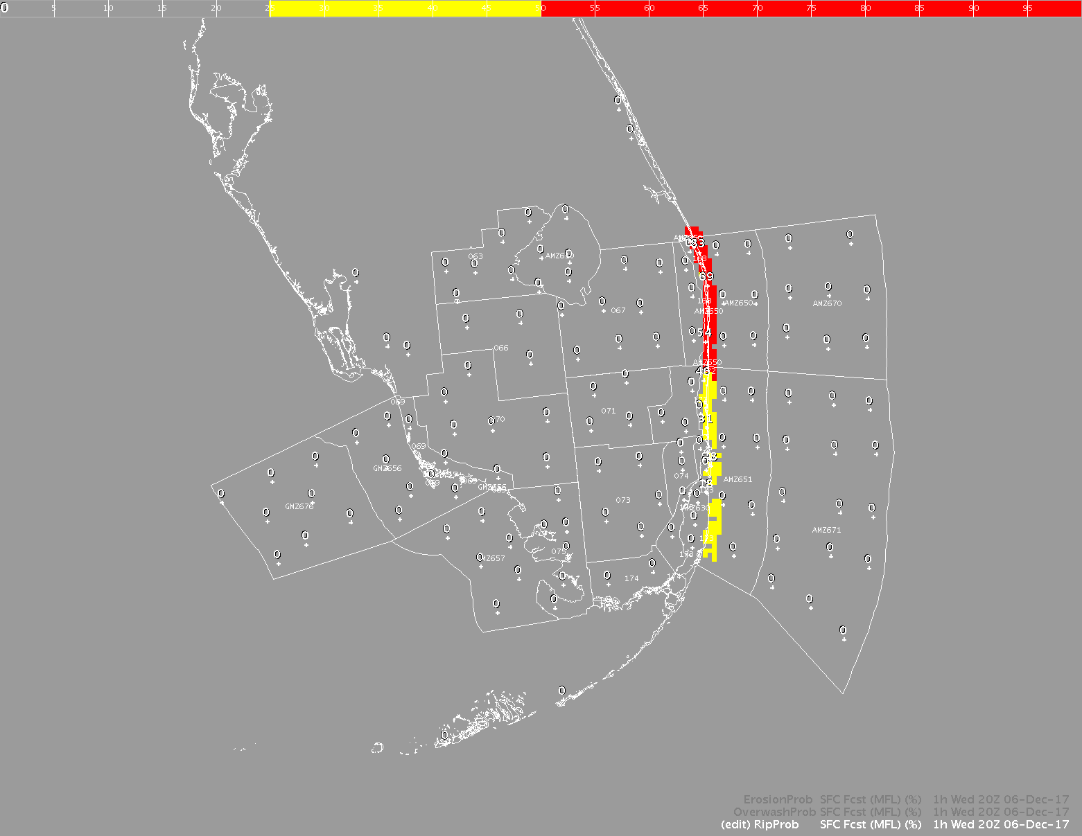
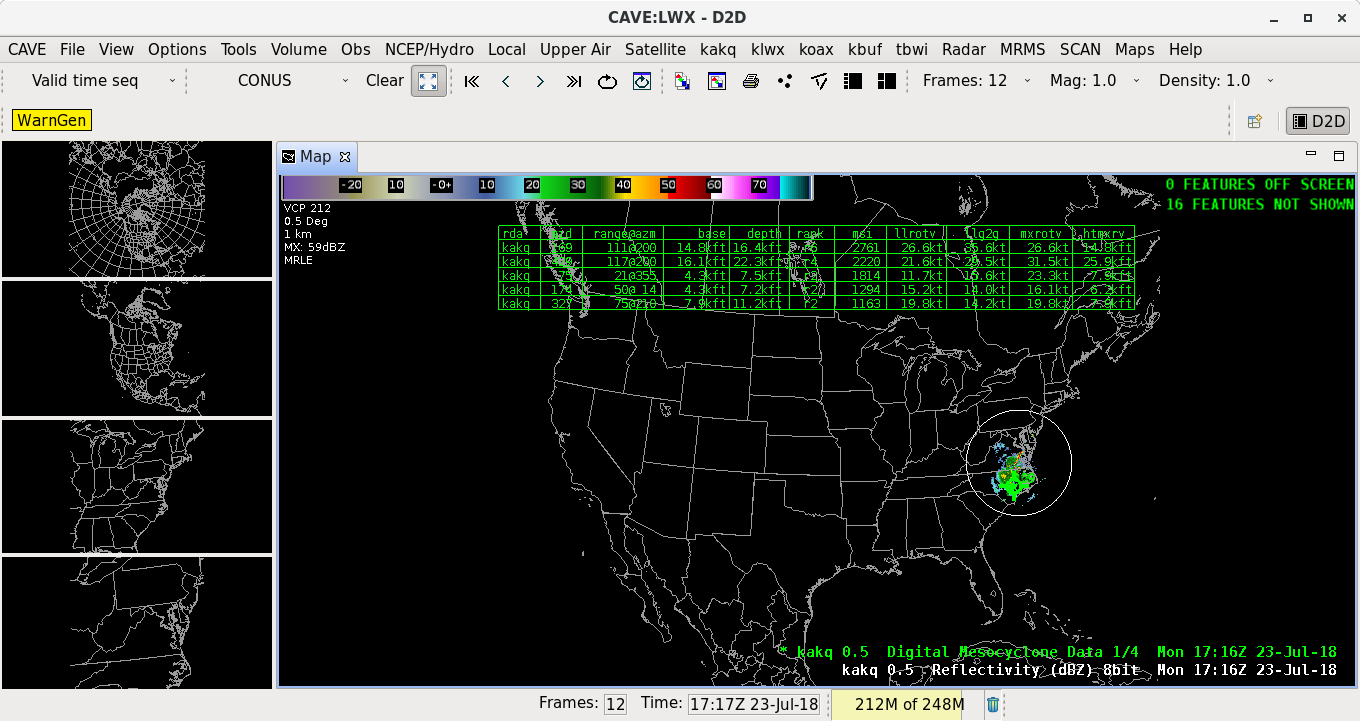
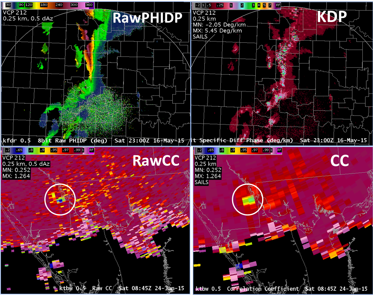
Radar |
- VCP 34
- 0.5, 0.9, 1.3, 1.8, 2.4, 3.1, 4.5° scans in 10 minutes
- Expected to replace VCP 31
- Raw ZDR Radar Data
- Best resolution comparable to Raw CC with 0.25 kilometer range gates and either 0.5° on SR cuts or 1.0° otherwise
- Not Centrally collected
|
| 23.2.2 |
2024/12 |
DPA |
- Digital Precipitation Array (DPA) Radar Product Removed
- Hourly Digital Accumulation Array (DAA) products can be used instead
|
| 23.2.2 |
2024/12 |
Focal Points |
- Nearshore Wave Prediction Model (NWPS) grib2 files updated in the LDM grib tables
- Speed boost of the Volume menus in D2D as LevelFactory.getAllLevels() was not using cached levels correctly before
- If RPG is running Build 23 the NEXRAD Unit Status will display incorrect number of SAILS cuts and may impact the use of VCP Change Requests when MPDA is active
- Bit order changes result in incorrect reading of the number of SAILS cuts
- Work around is to deactivate MPDA while using SAILS and VCP Change Requests
|
| 23.2.1 |
2024/01 |
Training |
- AWIPS 23.2.1 Overview in CLC (10 min; CLC, non-CLC web) Training
|
| 23.2.1 |
2024/01 |
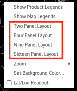
Multi-Panel Layouts |
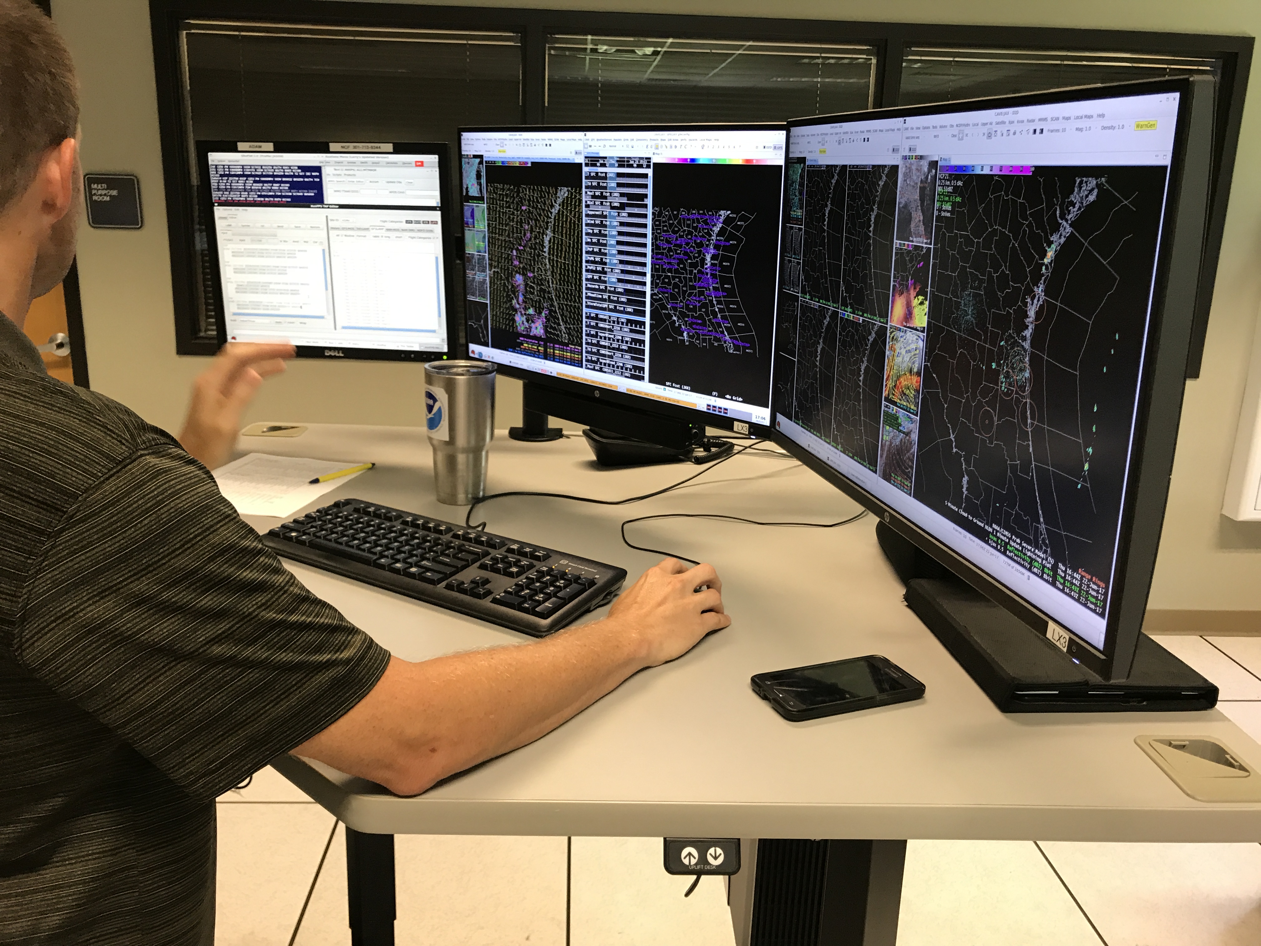
- Multi-Panel Layouts (Fig)
- 19 layouts available to optimize space on horizontal or vertical monitors
- Jobsheet: Multi-Panel Layouts (5 min)
|
| 23.2.1 |
2024/01 |
RRC |
- Rain Rate Classification (RRC) Product
|
| 23.2.1 |
2024/01 |
Canadian Radars |
- Canadian Radars
- Canadian S-band radar data anticipated to flow on SBN before the end of 2024
- Nationwide reflectivity mosaic
- Full dual pol suite available for Canadian dial radars (except no hydro classification algorithm)
- Jobsheet: Canadian Radars (5–10 min)
- Canadian Radars Reference Page
|
| 23.2.1 |
2024/01 |
Legacy LSR |
- Legacy LSR application has been removed
|
| 23.2.1 |
2024/01 |
SBN Filtering |
- Duplicate SBN data requests for non-dedicated radar connections are being filtered
|
| 23.2.1 |
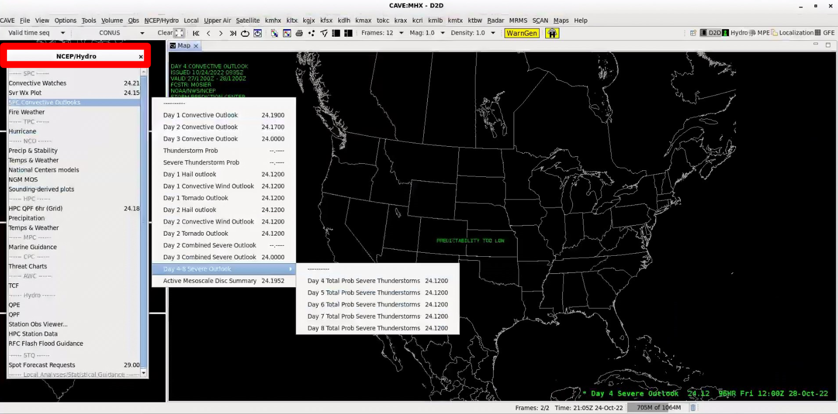
2024/01 |
SPC Day 4-8 Outlook |
|
| 23.2.1 |
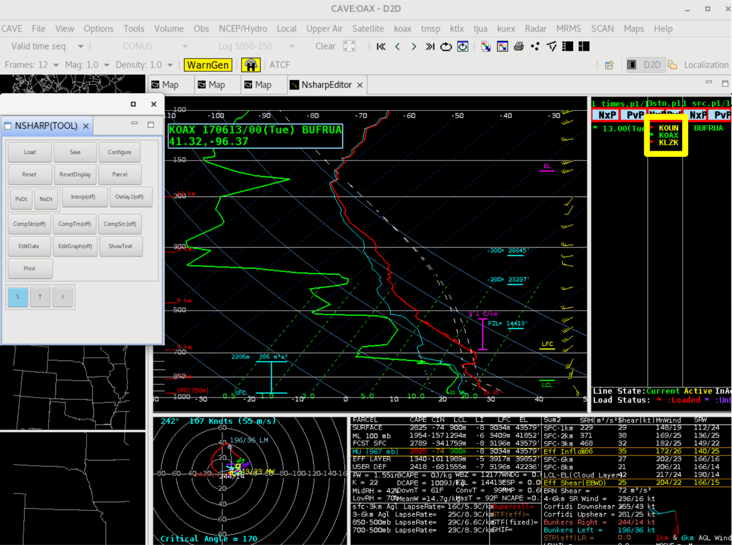
2024/01 |
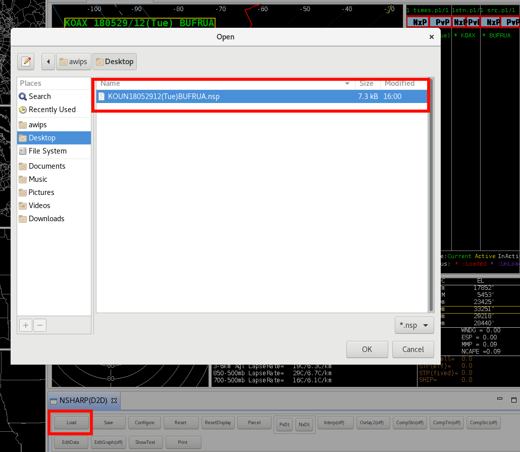
NSHARP |
- NSHARP Tool from Tools menu now supports multiple soundings
|
| 23.2.1 |
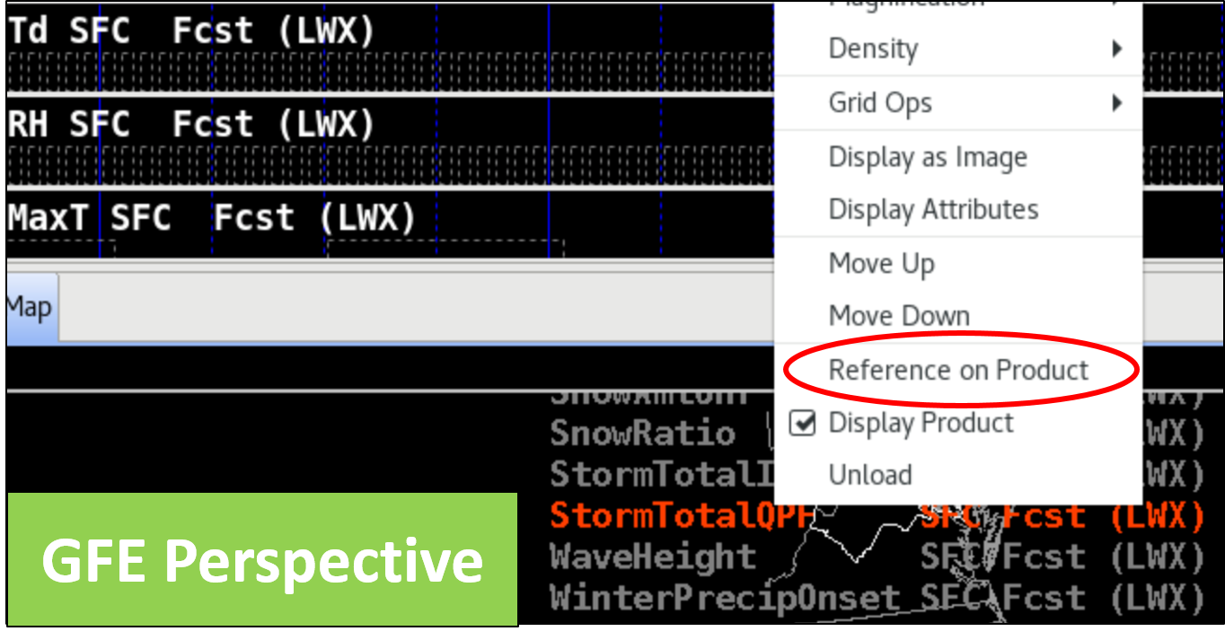
2024/01 |
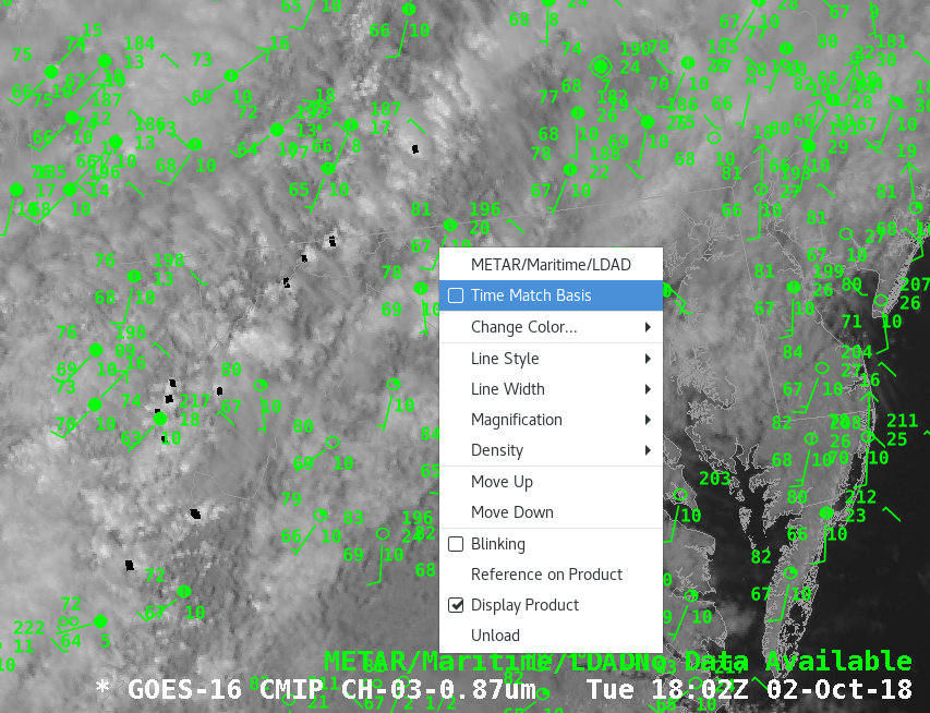
Reference on Product |
|
| 23.2.1 |
2024/01 |
TAF Display |
|
| 23.2.1 |
2024/01 |
Heatrisk |
- GFE-based experimental HeatRisk product anticipated in a dash release for all CONUS sites shortly after 23.2.1 deployment
|
| 21.4.1 |
2023/07 |
Training |
- AWIPS 21.4.1 Overview in CLC (15min; CLC, non-CLC Web, PDF) Training
- Hazard Services NWP and Winter
- NPW 1st - focal points configure NPW, set up GFE case for forecasters to use to take jobsheets
- Winter 2nd - focal points configure winter, set up GFE case for forecasters to use to take jobsheets in preparation for 2024-2025 winter season
|
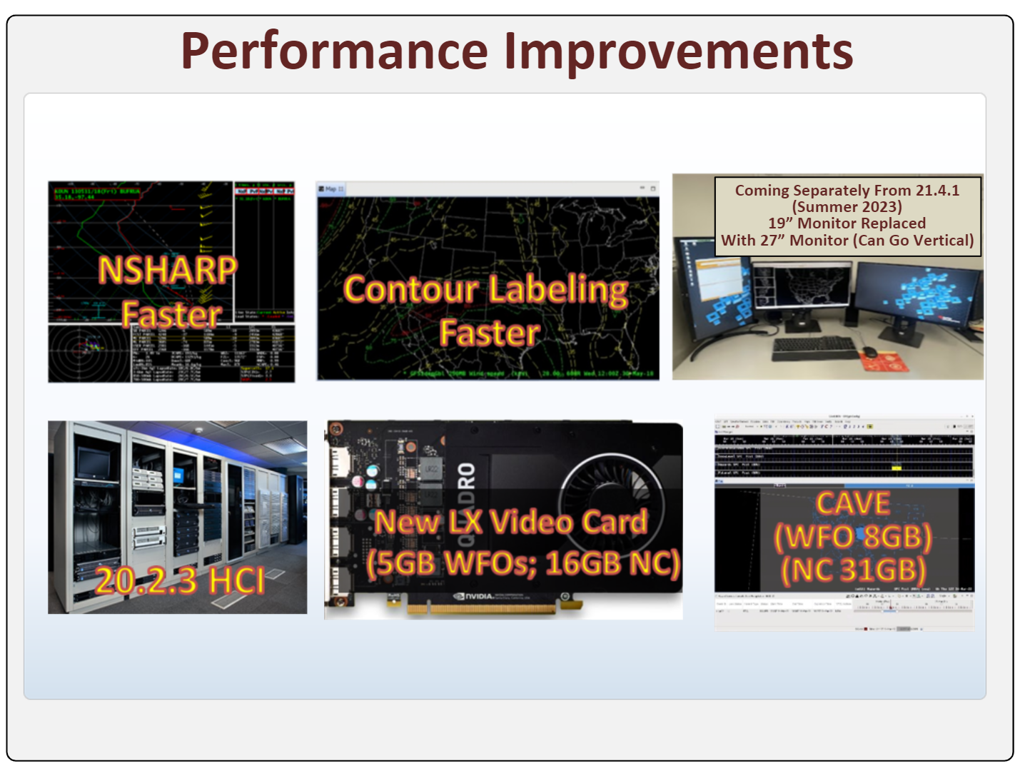
| 21.4.1 |
2023/07 |
Performance |
- Recent Performance Improvements (Fig)
- 20.2.3 HCI
- New LX workstations video card 5GB WFOs and 16GB NCs
- 21.4.1 CAVE 8GB WFOs and 31GB NCs
- NSHARP faster and model contour labeling faster
- Rotatable 27" monitor replacing 19" monitor (coming soon)
|
| 21.4.1 |
2023/07 |
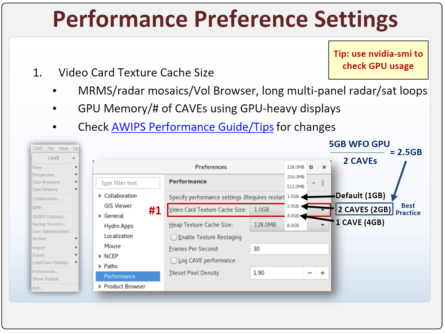
CAVE Preferences |
- CAVE->Preferences->Performance->Video Card Texture Cache Size (Fig; see jobsheet)
- Divide video card memory by number of CAVEs loading GPU-intensive data and select closest option under that to prevent running out of video card memory
- GPU intensive data - MRMS, radar mosaics, radar in the Volume Browser, large multi-panels with large frame counts containing radar/satellte data
- Use nvidia-smi at a command terminal after setting up workstation and looping through data to see how much video card memory is being used
- e.g. WFO 5GB video card memory/ 2 CAVEs loading data GPU-intensive = 2.5GB, so choose 2GB
|
| 21.4.1 |
2023/07 |
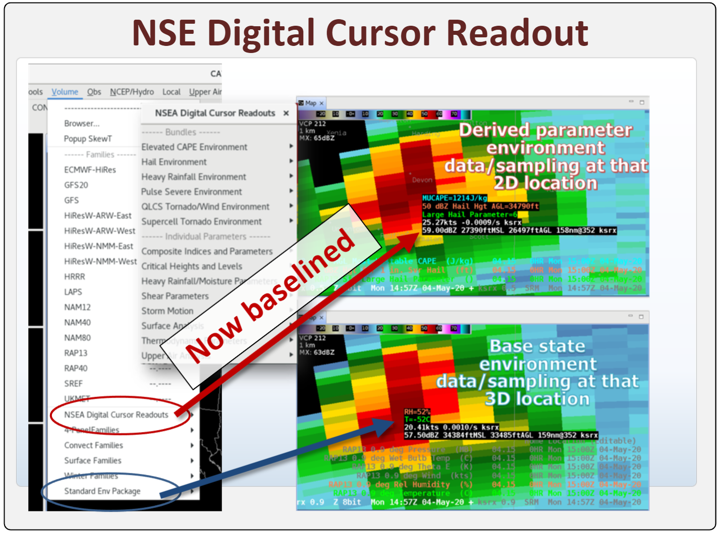
NSEA Digital Cursor Readout |
- NSEA Digital Cursor Readout now baselined (Fig; see jobsheet)
|
| 21.4.1 |
2023/07 |
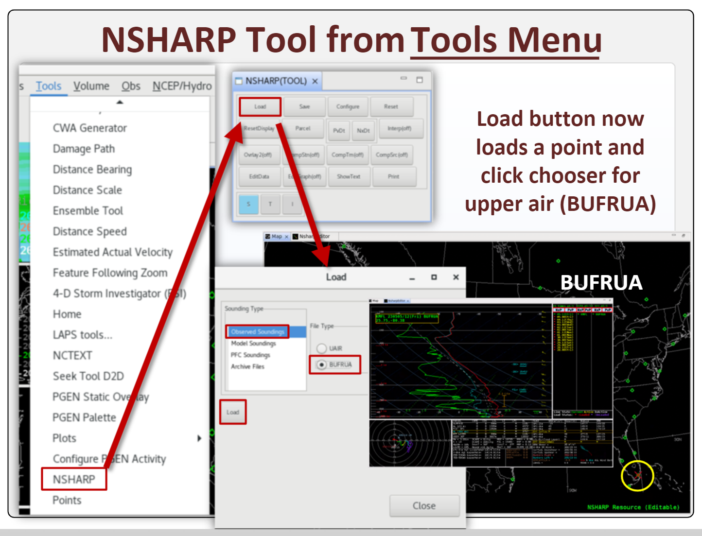
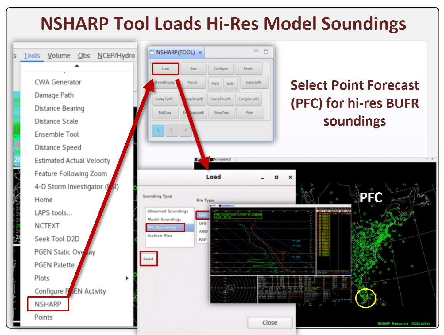
NSHARP |
- New NSHARP from Tools menu allows point and click loading on map (see jobsheet)
- NSHARP Tool Upper Air (Fig)
- NSHARP Tool Point Forecast Sounding (PFC; Fig)
|
| 21.4.1 |
2023/07 |
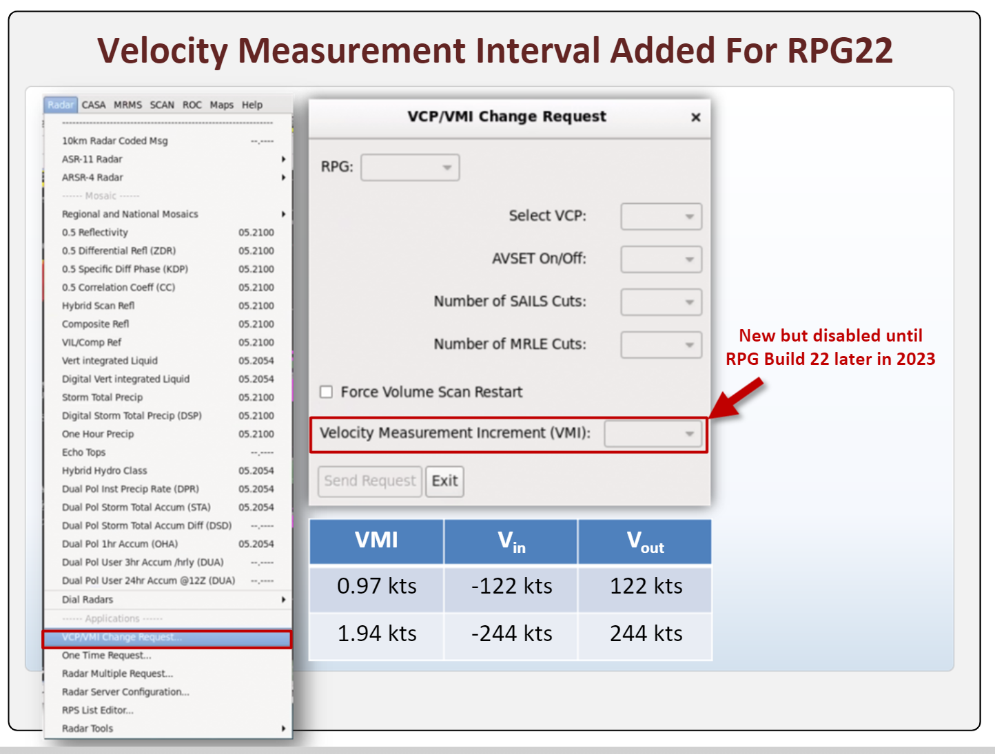
VCP/VMI |
- VCP/VMI Velocity Measurement Interval added to VCP GUI (Fig; see jobsheet)
|
| 21.4.1 |
2023/07 |
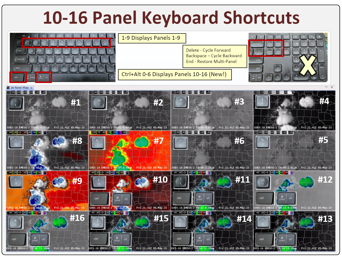
Keyboard Shortcuts |
- Multi-Panel Layout Keyboard Shortcuts (Fig; see jobsheet)
- Ctrl+Alt+[0-6] extends zooming in to panels 10-16 of a 16 panel with one product loaded per panel
- Other useful keys above keyboard arrows (not keypad)
- Delete - cycle forward
- Backspace - cycle backward
- End - return to multi-panel layouts
|
| 21.4.1 |
2023/07 |
MRMS |
|
| 21.4.1 |
2023/07 |
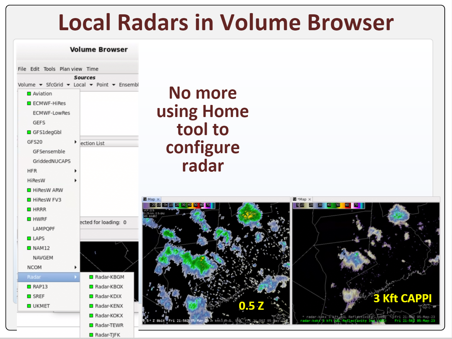
Volume Browser Radar |
- Local radars now under Radar Source in Volume Browser (Fig)
- No longer need to specify location with Home tool
|
| 21.4.1 |
2023/07 |
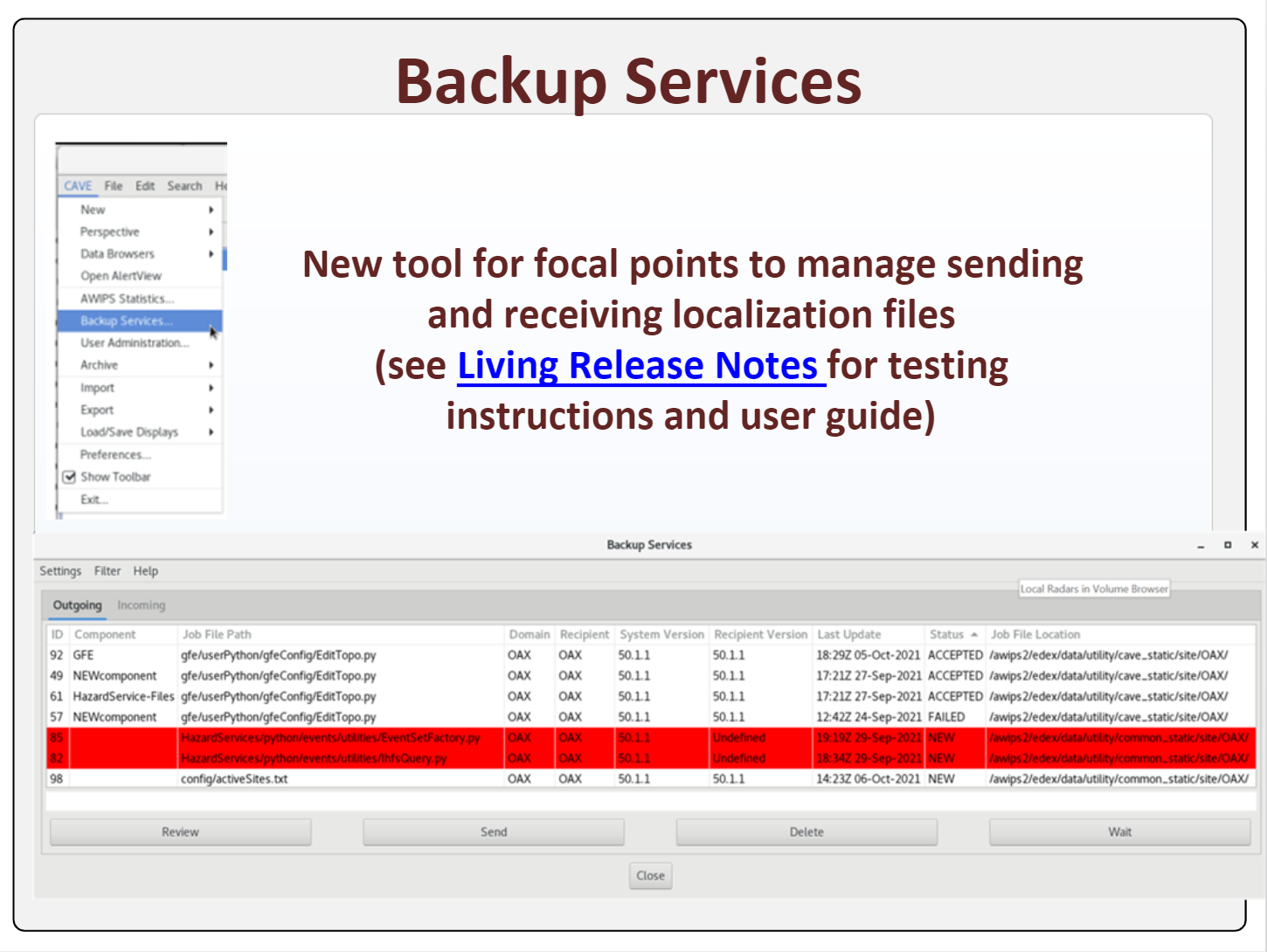
Backup Services |
- Backup Services now manages sending/receiving localization files between sites (Fig)
|
| 20.2.3 |
2021/04 |
Training |
- AWIPS Build 20.2.3 Informational Overview in CLC (10min; CLC, non-CLC Web, PDF)
- Hazard Services
- Hydro Changes (10min; CLC, non-CLC Web, PDF)
- Hydro Haz Simplification (CLC, non-CLC Web, PDF)
- 20.2.3 Hazard Services Overview for Focal Points (15min; CLC, non-CLC Web, PDF)
- Warning Content: Impact Based Warnings (25min; CLC, non-CLC Web) and SPS for Near Severe Storms (15min; CLC, non-CLC Web)
|
| 20.2.3 |
2021/04 |
Hazard Services |
- RIverPro WWA disable (non-hazard generation continues)
- Flash Flood Warning Calls To Action Statements (CTAs)
- "Urban Areas", "Rural Areas", and "Flash Flood Warning means" removed
- "Avoid flooded roads" added
- Consolidated rainfall information
- New formatting for human-reported flooding
- HID widgets moved
- Hydro Hazard Simplification - all hazards issued through Hazard Services, WarnGen phasing out for Hydro
|
| 20.2.3 |
2021/04 |
CAVE/D2D |
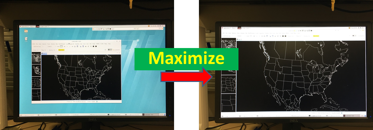
- Multi-panel Layouts (Fig)
- Multi-color and Multi Line-style contouring (Fig)
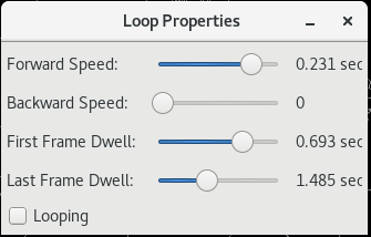
- Faster looping options (Fig)
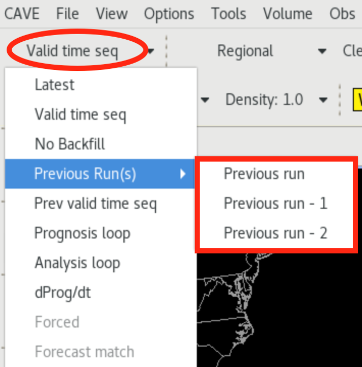
- Display previous 3 model runs (Fig)
- Frame count display (Fig)
- Ingest and display National Blend of Models (NBM) v3.2 from Volume Browser (Fig)
- New time loading options (Fig)
|
| 20.2.3 |
2021/04 |
AIR |
- Can use AWIPS Interactive Reference (AIR) to access reference and training material from GFE, Hydro, and MPE perspectives (Fig)
|
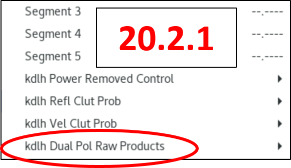
| 20.2.3 |
2021/04 |
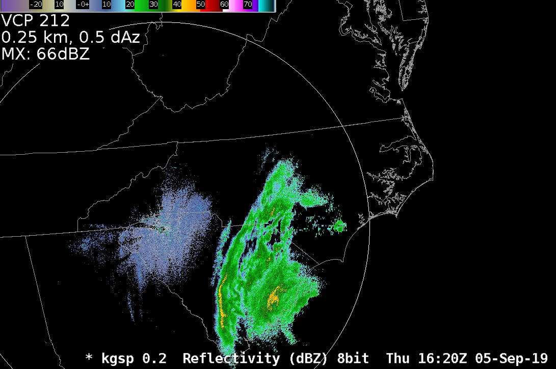
Radar |
- KGJX, KFSX, KDLH sites added to scan below 0.5 degrees
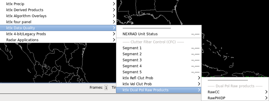
- Dual pol raw products are now restored in data quality menu for stations that scan below 0.5 degrees (Fig)
|
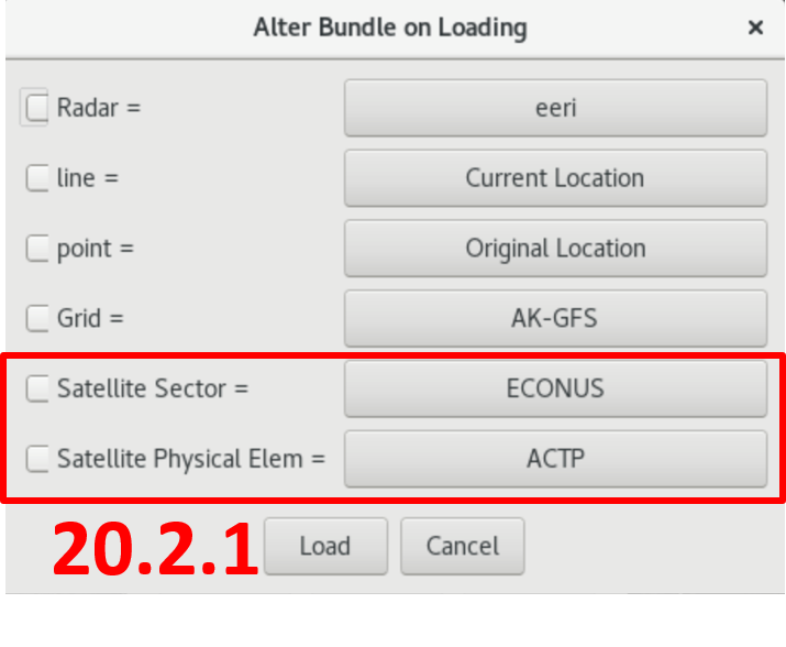
| 20.2.3 |
2021/04 |
Satellite |
- Aerosol detection dust and smoke derived products automatically rename the editor tabs
- "Alter" function in procedures to switch out satellite products (Fig)
|
| 20.2.3 |
2021/04 |
FFMP |
- FFMP Basin table works again (those who removed ARIs to fix the previous table launching problem should remove the FFMPSourceConfig.xml and bounce EDEX to restore ARIs)
|
| 20.2.3 |
2021/04 |
WarnGen |
- IBW severe WarnGen changes (turnkey after 20.2.3 deployment)
|
| 20.2.3 |
2021/04 |
Focal Points |
- Hazard Services new methods changing requires configuration during install to restore hydro operations
- Addition of GOES-R composite products into NOAAPORT_OPT
- BLU alerts added to HazCollectTrigger.template
- Unified dictionary - Hazard Services, GFE, collaboration, text WS
- Flag tdwrCollectionLimited - removed from the Radar Server
- FFMP broke previous build - new fix, can restore ARIs workaround
|
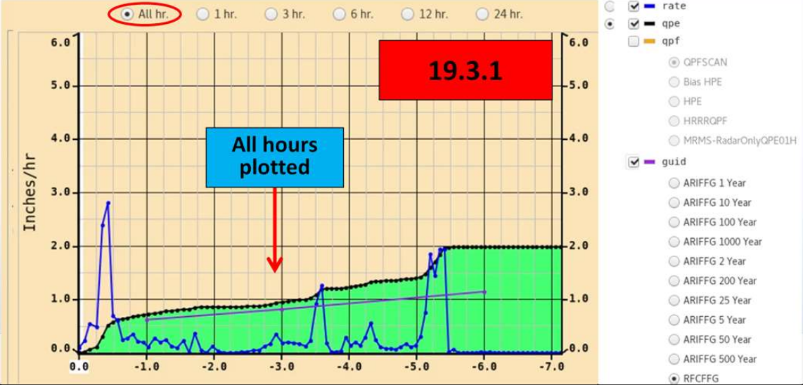
| 19.3.1 |
2019/12 |
Training |
|
| 19.3.1 |
2019/12 |
Hazard Services |
- see Hazard Services VLab reference page for references
- New hazard generation software in AWIPS (Fig)
- Use it to issue all watch, warning, and advisory products for hydro
- Replaces WarnGen hydro component, RiverPro, GHGH
- Only hydro in this build
- Winter, Convective, Marine, etc will be progressively added over the next 2 years
- Lots of training
- User and focal point online training (Link)
- Focal Point residence workshops in at WDTD in Norman, OK
|
| 19.3.1 |
2019/12 |
CAVE/D2D |
- Display PGEN as background data (Fig)
- Obs time match basis now works again (Fig)
- Distance Scale Tool new units added (Fig)
- Nautical miles (nm), kilometers (km)
- Data Delivery
- GUI Changes
- filtering options removed from the Dataset Discovery Browser
- ability to filter by group removed from the Data Delivery Subscription Manager
- active period handling removed from the Dataset Delivery Subscription Manager
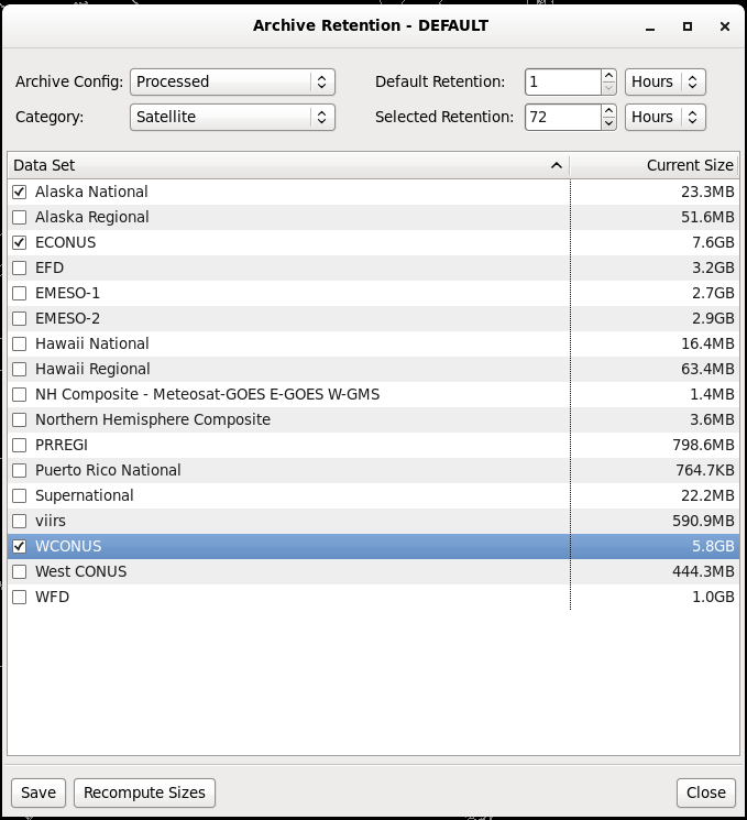
- Archiver
- Satallite data retention changed from 168 to 72 hours (Fig)
- Most offices have site overrides so impact is minimal
|
| 19.3.1 |
2019/12 |
Radar |
- More sites scan below 0.5 degrees (Fig)
|
| 19.3.1 |
2019/12 |
NSHARP |
|
| 19.3.1 |
2019/12 |
FFMP |
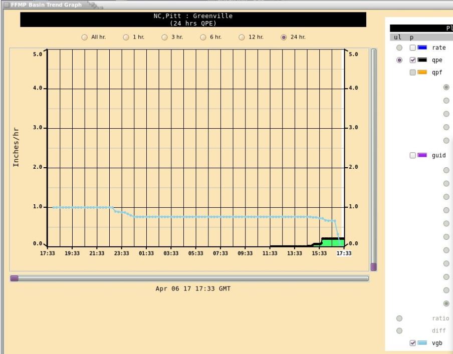
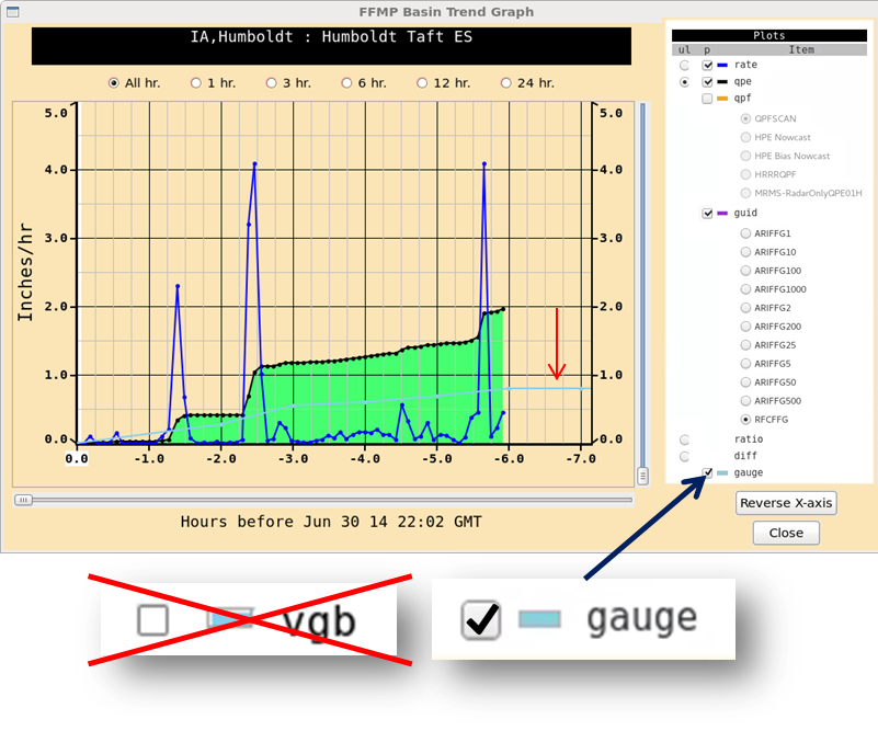
- FFMP Basin Trend plots all hours independent of the time duration slider bar (Fig)
|
| 19.3.1 |
2019/12 |
Focal Points |
- Manual endpoint relocated to /data_store/dropbox
- AlertViz action can now be any executable script
- Place scripts in cave_static/*/*/alertviz/actions
- Updated XML TAF encoder for AvnFPS
- BLU PILs added to the National Dataset Maintenance (NDM) afos2awips.txt
- Python 3 coming in 20.3.1
|
| 19.2.1 |
2019/08 |
Training |
|
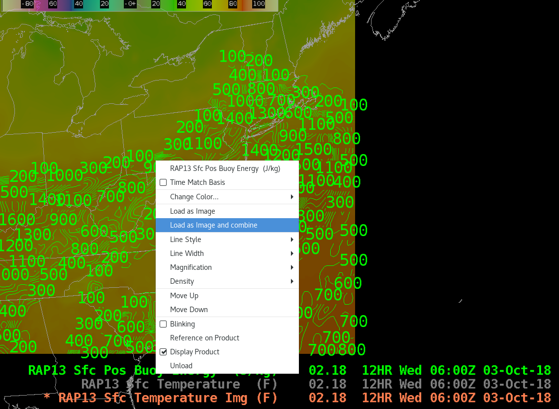
| 19.2.1 |
2019/08 |
CAVE/D2D |
- NSHARP auto update, loop, and display fixes
- Load as Image and Combine (Fig)
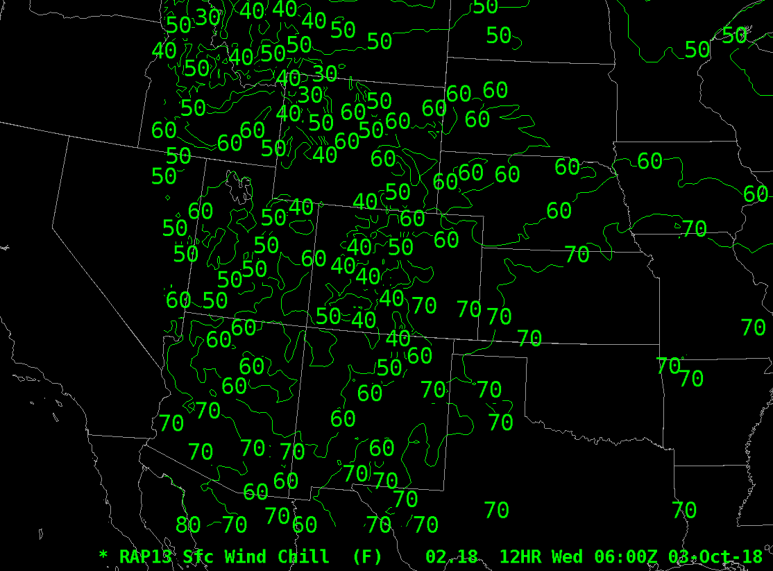
- Model derived windchill units changed to Fahrenheit (Fig)
- Flood Warnings issued in RiverPro now display in CAVE
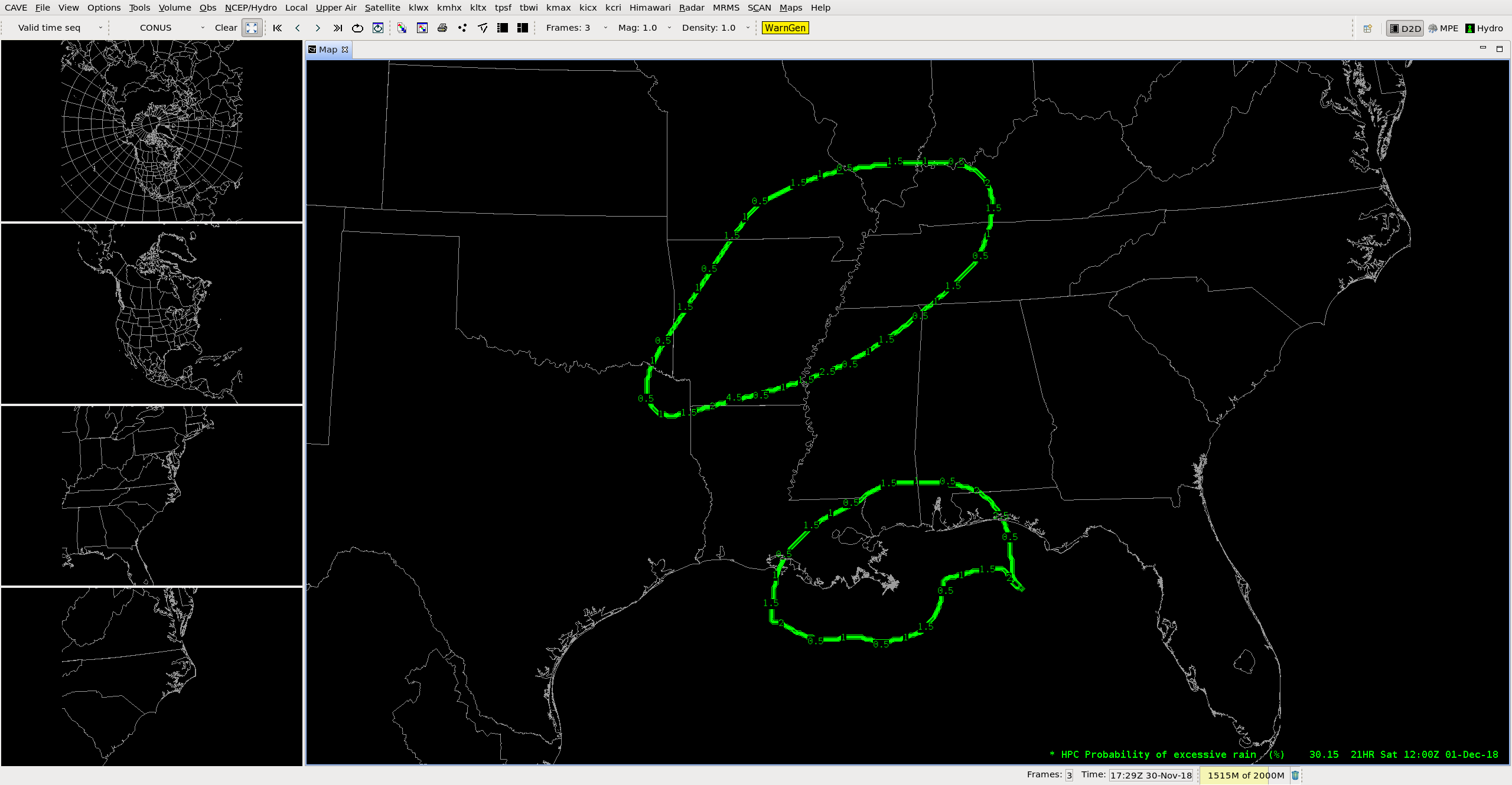
- 1-3 Day excessive rainfall data displays (Fig)
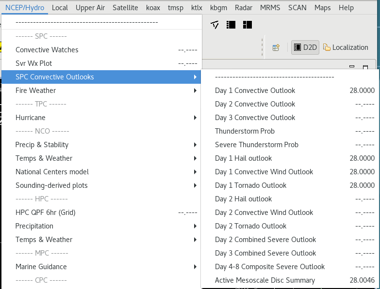
- SPC Day 2 individual parameters (Fig)
- Submenus maintain checkboxes when torn off
- FFMP VBG trace not backwards anymore (Fig)
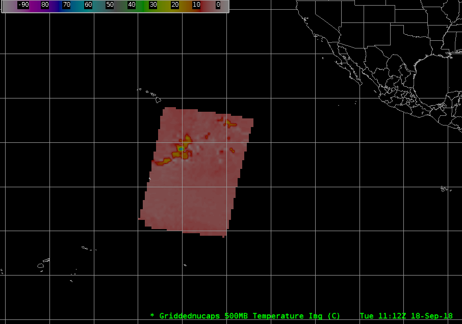
- NUCAPS plan view (Fig)
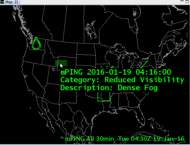
- mPing auto updates (Fig)
|
| 19.2.1 |
2019/08 |
Radar |
- MRLE
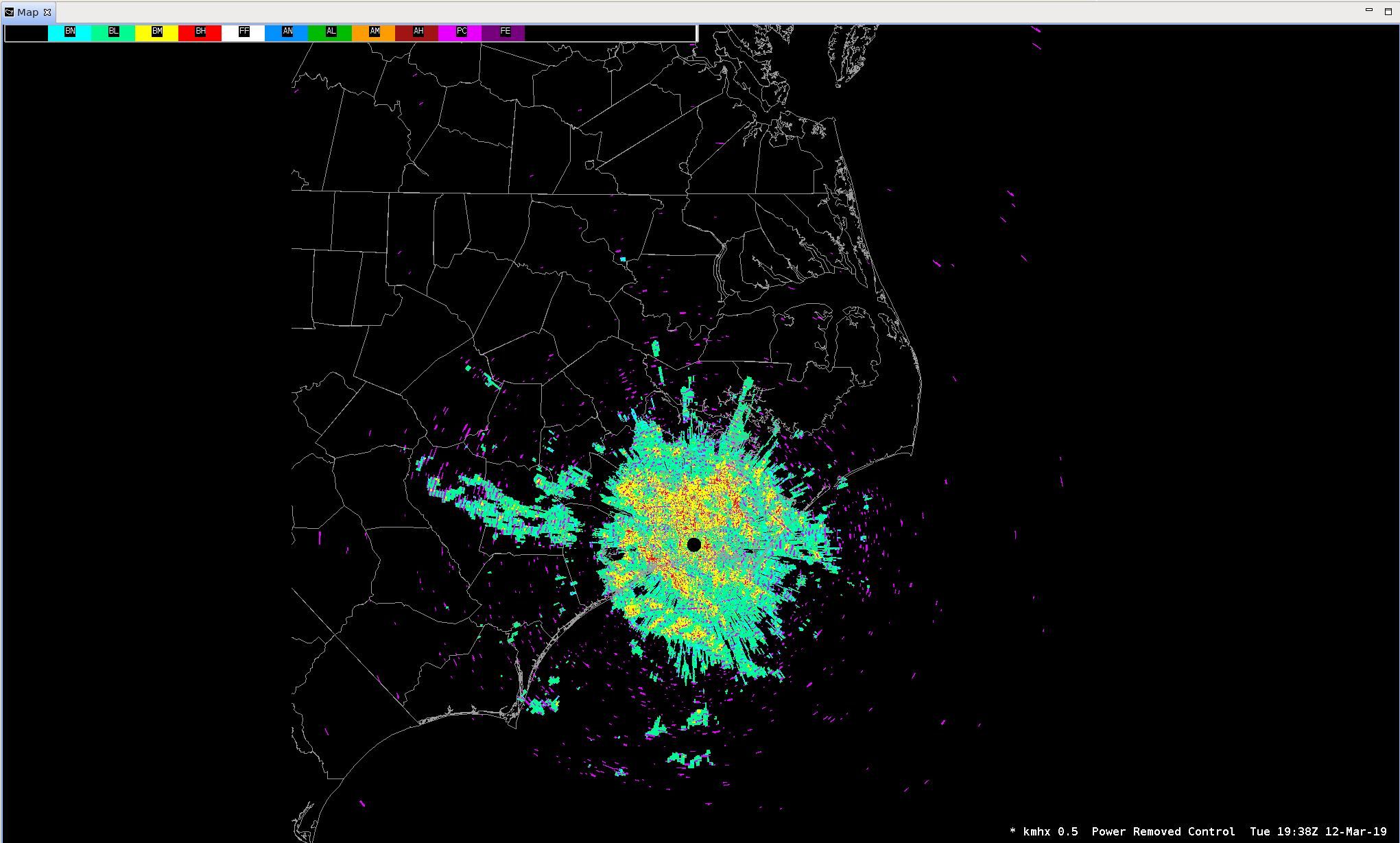
- Power Removed Control product (Fig)
|
| 19.2.1 |
2019/08 |
MRMS |
- MRMS Version 12
- New products and OCONUS expansion (Fig)
- LDAD feed first, SBN delayed
|
| 19.2.1 |
2019/08 |
Climate |
- Appeared as a new perspective in CAVE in 18.1.1, now ready to be used in this build
|
| 19.2.1 |
2019/08 |
Flash Flood |
- Turned off by default
- Coordinated date to turn on later in 2019 after after field test
|
| 19.2.1 |
2019/08 |
Focal Points |
- uEngine decommissioned
- GFE changes
- GFE based TAF formatter
- purgeAllGrids script
- default smartinit threads changed from 1 to 3
- IBW Flash Flood WarnGen templates
- createUserTopoFile, display time independent NetCDF data in CAVE
- FixDoubleBoundaries.py, fixes bundles with separate shared boundaries
- TOWR-S RPM enhancements
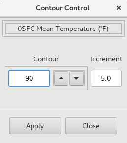
- Contour control (Instructions for freezing the contours)
|
| 18.2.1 |
2019/03 |
Training |
- 18.2.1 Informational Overview (14min; Training in the CLC (Internet access only), speaker notes PDF, No Jobsheets)
- Significant DR backlog addressed in this build as well as the subsequent 19.2.1 release.
|
| 18.2.1 |
2019/03 |
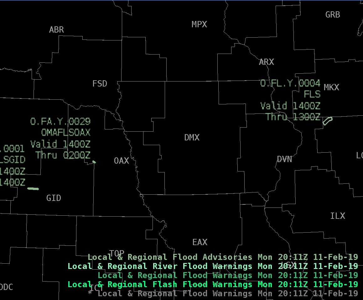
CAVE/D2D |
- Saved NSHARP display can now be loaded without errors (Fig)
- Time-Match basis preserved in bundles
- Display regional flood advisories without issues (Fig)
- Time of Arrival Tool
- No more "Unrealistic Point of Arrival" label for point and circular front
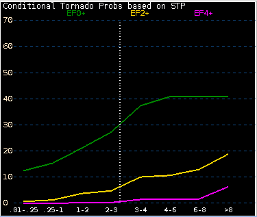
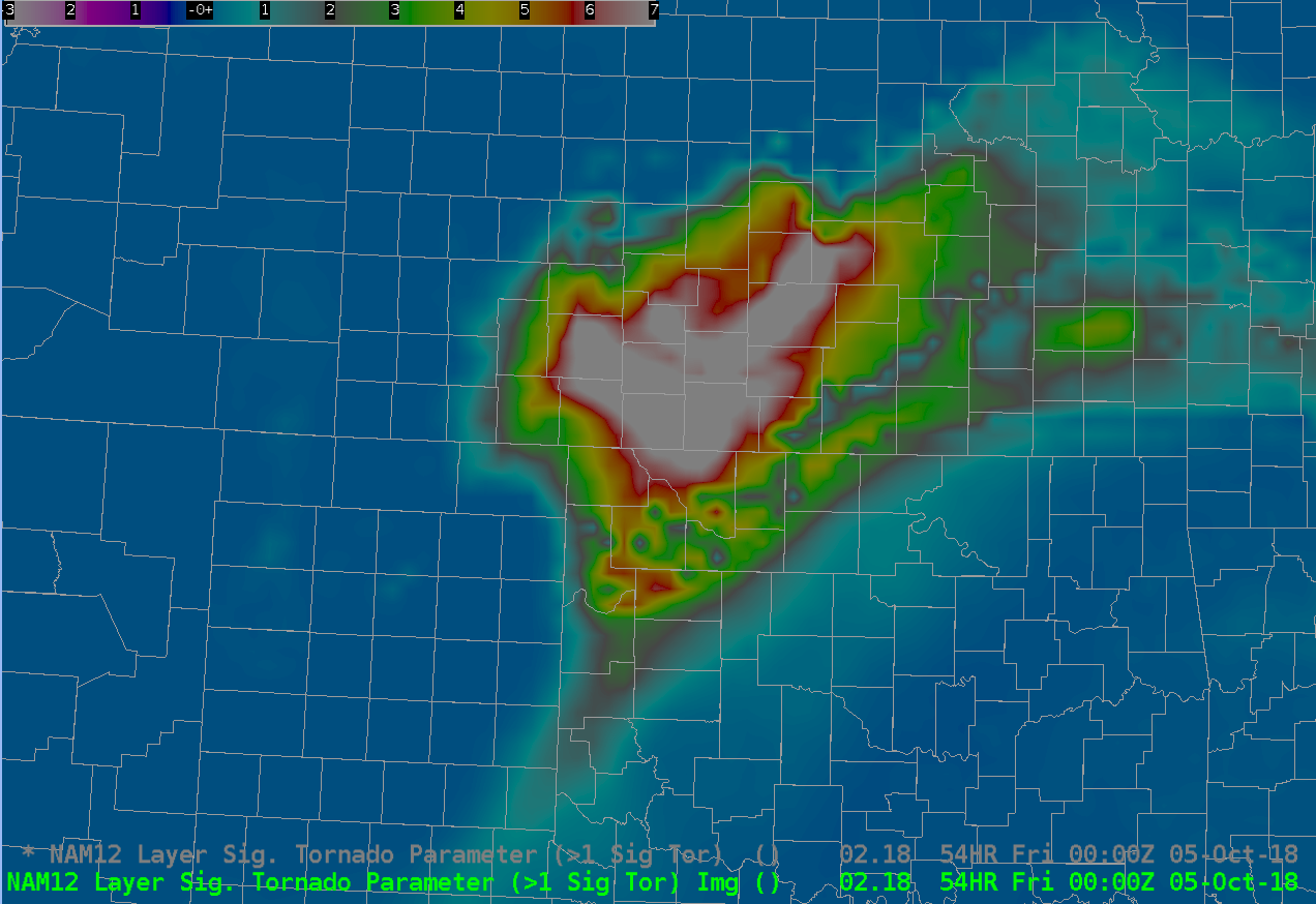
- Significant Tornado Parameter (STP) loads from Volume Browser (Fig)
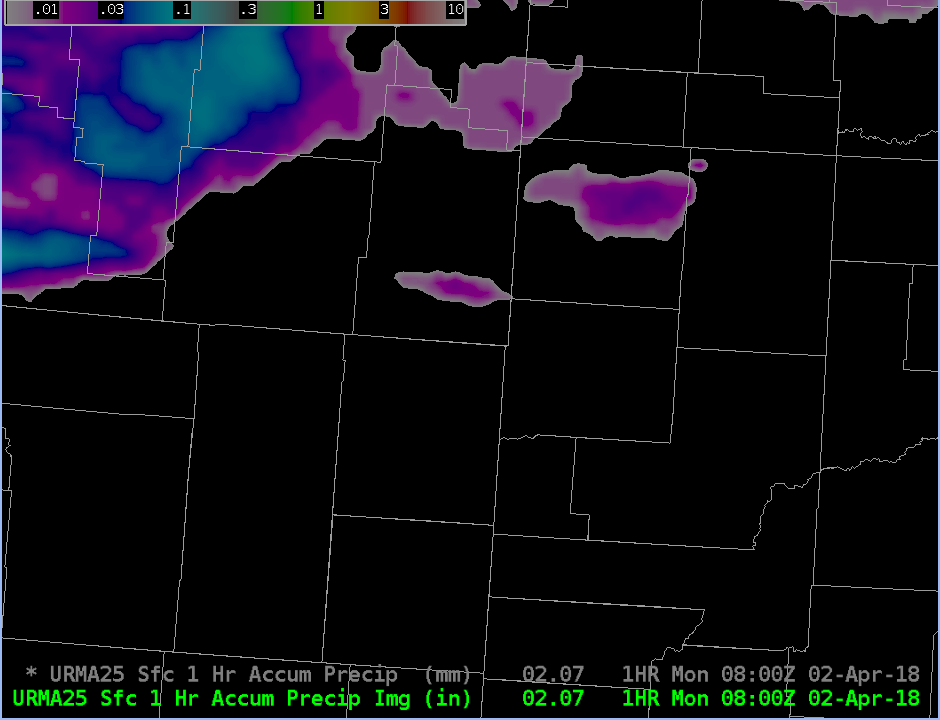
- Unrestricted Mesoscale Analysis (URMA)
- Hourly RFC Stage IV precipitation accumulation products added (Fig)
|
| 18.2.1 |
2019/03 |
Radar |
- Dual-pol precip bias has N/A label (Fig)
- Tear off both Z and V for the same dedicated radar (Fig)
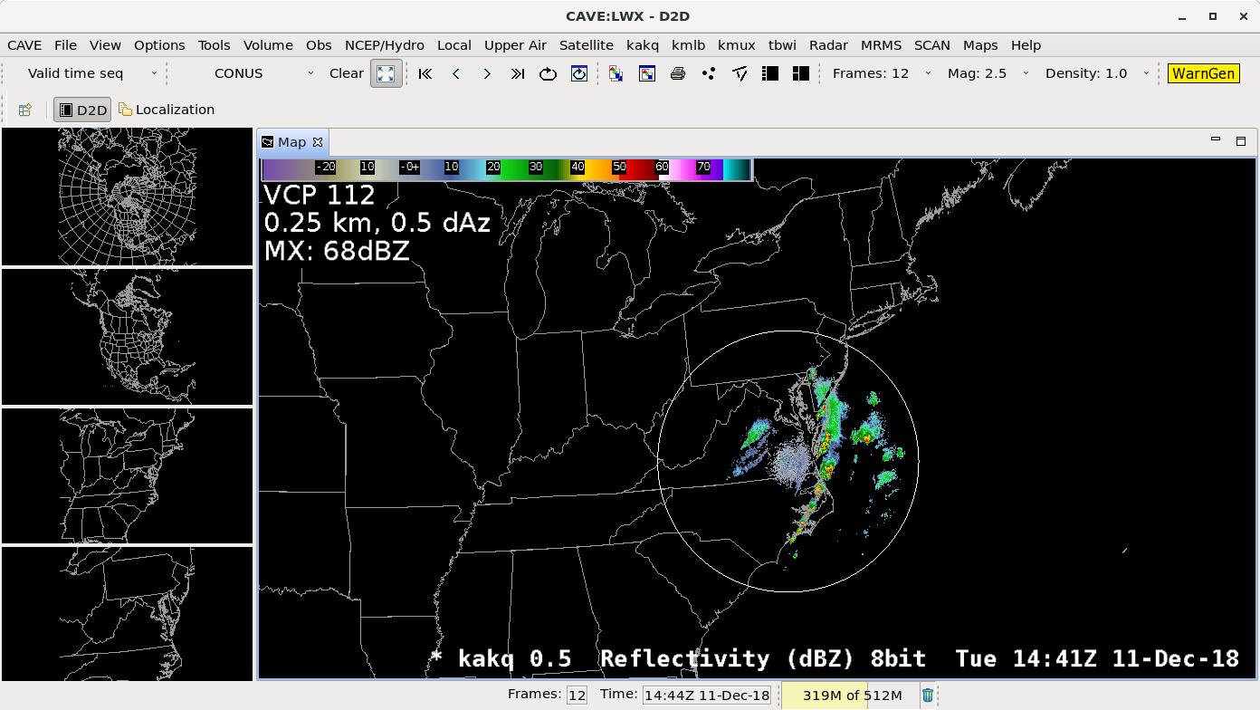
- New VCP 112 improves range folding by combining back to back SZ-2 velocity scans at 0.5, 0.9, 1.3 degrees (Fig)
- Reflectivity cross section can now be loaded from the volume browser without having to worry about mapping error
|
| 18.2.1 |
2019/03 |
Satellite |
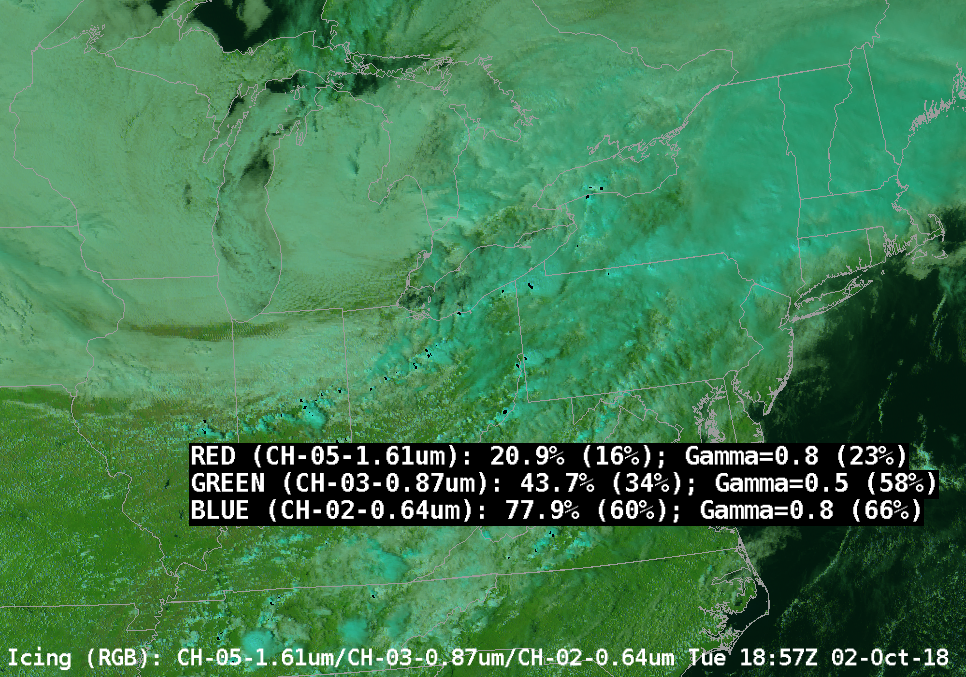
- GOES-R
- Improved sampling to include channel name and gamma setting (Fig)
- sumbmenu re-organization
|
| 18.2.1 |
2019/03 |
WarnGen |
- WarnGen
- 0.75" hail changed from dime to penny sized in the template of the Significant Weather Advisory and Special Weather Statement
|
| 18.2.1 |
2019/03 |
Focal Points |
- µEngine finally decommissioned in the next build (19.2.1)
- Sites may have duplicate entries for the NBM in the pqact.conf.xxx file which can negatively affect system performance
|
| 18.1.1 |
2018/10 |
Training |
|
| 18.1.1 |
2018/10 |
CAVE/D2D/GFE |
- National Blend of Models version 3.1 additional data elements (echo tops, simulated max reflectivity, VIL for CONUS and ceiling, visibility, lowest cloud base, QPF, and PPI for OCONUS)
- NWPS rip current guidance (Fig)
- Used with GFE and Volume Browser, but data delayed until late 2018/early 2019
- FDTD will release training coincident with deployment in 2019
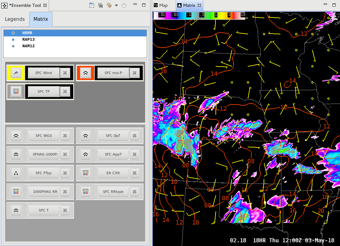
- Ensemble Tool's matrix viewer works correctly (Fig)
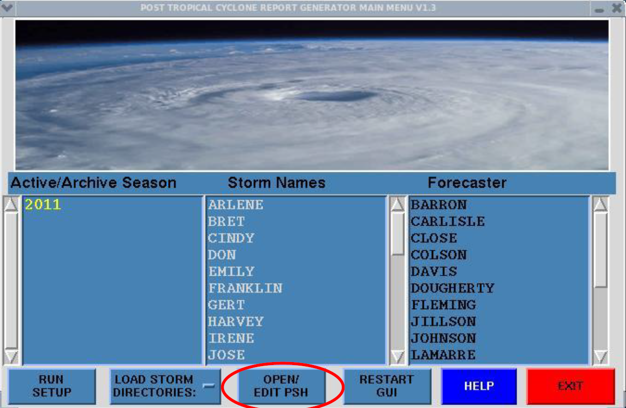
- Post Tropical Cyclone Report Generator (PSH) (Fig)
- Support for a local application that gathers post-storm data and creates a standardized report
- FDTD training planned for 2019 tropical season
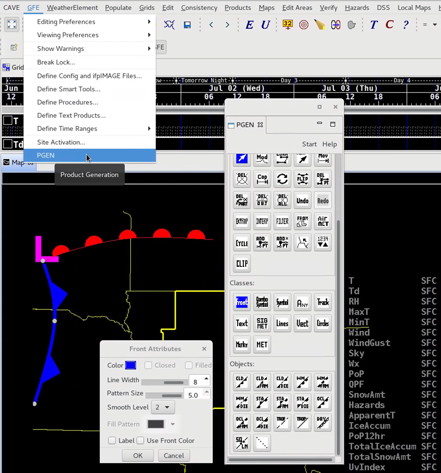
- PGEN Palette (loaded from D2D Tools menu)
- Create shareable overlays (text, shapes, fronts, etc.) in CAVE with this initial capability that will be expanded upon in future builds (New Jobsheet)
- Data Delivery (CAVE->Data Deliver-> Dataset Discovery Browser)
- "Friendly" naming convention for models and parameters in the Data Delivery subscription capability managed from the CAVE menu
|
| 18.1.1 |
2018/10 |
Radar |
- Support for specific sites with elevation angles below 0.5 (Fig)
- Mid-Volume Rescan of Low Level Elevations (MRLE) support, full deployment with RPG 19 in 2019 (Fig)
|
| 18.1.1 |
2018/10 |
Climate |
- Available in Open Perspective window but release is delayed to 18.2.1, so don't use it yet
- Will replace previous application with new CAVE version and new database
|
| 18.1.1 |
2018/10 |
WarnGen |
- Preset Threat Area button replaces Dam Break Threat Area (can be used for airport weather warnings, dam break and burn scar warnings)
- Cancelled polygons in local warnings display update correctly (Fig)
|
| 18.1.1 |
2018/10 |
Focal Point |
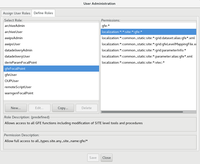
- Very handy search capability added to Localization Perspective (Fig)
- User Roles framework modified with new GUI from CAVE->User Administration menu (Fig)
- Need to reassign roles, only awips admin users have retained their roles (see Living Release Notes 18.1.1 tab)
- geospatialConfig_ALASKA_MARINE.xml file for Alaska Region
|
| 17.3.1 |
2018/04 |
Training |
- 17.3.1 Informational Overview (12-15min; training in the CLC (Internet access only), speaker notes PDF, Ensemble Tool Jobsheet)
- Note: if you completed early versions of the training in the CLC (before 4/23/2018), you will need to re-request the training in the CLC to see the latest version in the CLC.
|
| 17.3.1 |
2018/04 |
CAVE/D2D/GFE |
- Ensemble Tool enhancements
- Tracking Meteogram Tool no longer breaks keyboard shortcuts
- Model enhancements
- National Blend of Models
- ceiling height, visibility, QPF
- HRRR, RAP, GLAMP, HRRR-GLAMP MELD
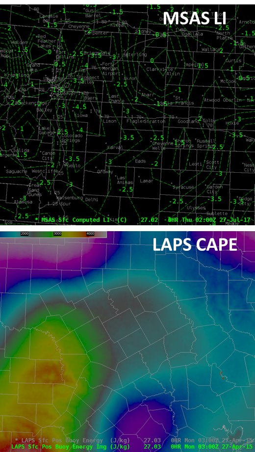
- Bug fixes for LAPS/MSAS data
- GFE
- PGEN added to GFE menu
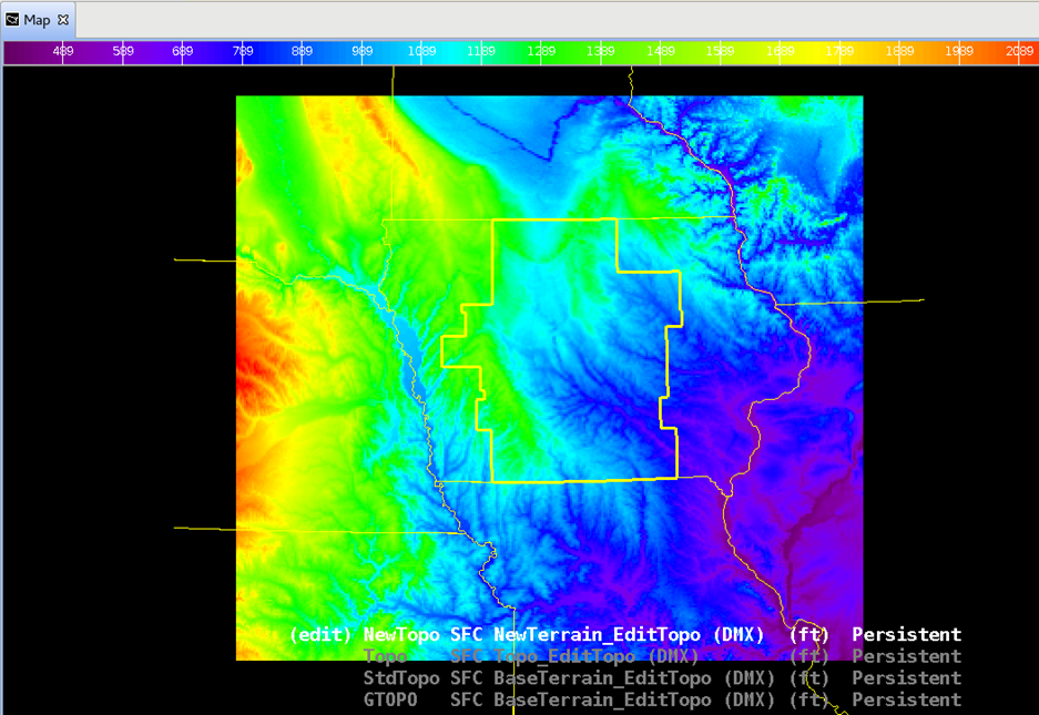
- New topography file
- NAVD88 vertical datum
- Includes Coastal Relief Model (CRM) that improves coastline accuracy
- Availalble for AK, HI, PR (variety of input sources)
- Same 2.5km grid as before
|
| 17.3.1 |
2018/04 |
Radar |
- Radar RPG Build 18 changes
|
| 17.3.1 |
2018/04 |
Tropical |
|
| 17.3.1 |
2018/04 |
FFMP |
|
| 17.3.1 |
2018/04 |
MRMS |
- New baseline FLASH MRMS menu
- QPF products not anticipated for some time; SBN FLASH data distribution later in 2018
|
| 17.3.1 |
2018/04 |
WarnGen |
|
| 17.3.1 |
2018/04 |
AvnFPS |
- AvnFPS XML TAF format automatically produced
|
| 17.3.1 |
2018/04 |
Focal Points |
- Postgres authentication enforced on local apps
- File permissions restricted on NFS shares
- world read removed for all files using script
- /awips2/fxa/bin/set-nfs-perms.sh sets strict file permissions
- Distribution files in localization perspective
- HREF ingest
- WarnGen configuration option to filter cities outside CWA
- uncomment warnGenCWAFilter tag for cwa mapping key in geospatialConfig_* xmls
- best practice: remember to compare SITE overrides to baseline templates and merge in changes each build
- Override behavior now documented at the top of xmls
- AlertViz scripting now works to run programs off of alert settings
- GFE Spot Formatter update required
- VGB filtering in FFMPTemplateConfig.xml through localization perspective now fixed, e.g.:
- <excludedVGBs>
<vgb>AXA</vgb>
</excludedVGBs>
- Backup localization capability (
- Warning! Do not use until regional guidance is provided, or you may delete files accidentally! See Living Release Notes
|
| 17.2.1 |
2017/12 |
Training |
|
| 17.2.1 |
2017/12 |
CAVE/D2D |
|
| 17.2.1 |
2017/12 |
RedHat |
|
| 17.2.1 |
2017/12 |
AlertViz |
- AlertViz bar sometimes freezes
|
| 17.2.1 |
2017/12 |
Focal Points |
- Upgrade to 64bit LDM
- Permissions and Local Apps Authentication
- Pacemaker replaces Heartbeat
|
| 17.1.1 |
2017/03 |
Training |
|
| 17.1.1 |
2017/03 |
CAVE/D2D |
|
| 17.1.1 |
2017/03 |
Tropical |
|
| 17.1.1 |
2017/03 |
AIR |
- AWIPS Interactive Reference update
|
| 17.1.1 |
2017/03 |
MPE |
- MPE integrated into AWIPS 2 infrastructure
|
| 17.1.1 |
2017/03 |
Focal Points |
|
| 16.4.1 |
2016/12 |
Training |
- 16.4.1 Informational Overview (11min) speaker notes PDF, training in the CLC (Internet access only) - released Dec 21, 2016
- includes forecaster training on the AWIPS Interactive Reference and supplemental AWIPS Interactive Reference training for VLab contributors covering how to register content in the VLab for use with AIR
|
| 16.4.1 |
2016/12 |
CAVE/D2D |
- Eclipse and Java changes implemented in 16.3.1 are deployed in 16.4.1 with some minor changes in buttons and menus
- Perspectives buttons cannot be moved
- Side panes can no longer be adjusted to 0 width (min size is 10% CAVE window)
- Editor right click menus different, no move group tabs option
- Drag and drop editors to split main panel now no longer requires placement on CAVE pane edge
|
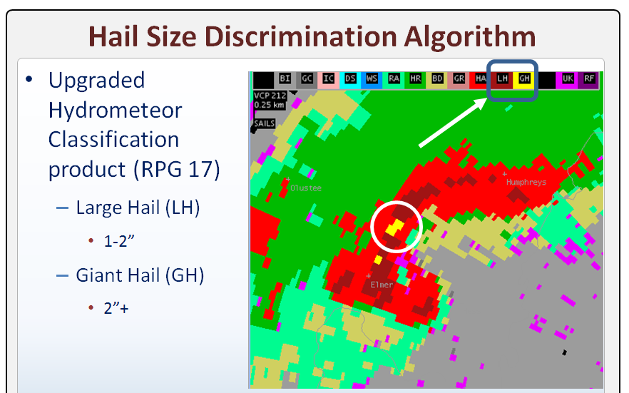
| 16.4.1 |
2016/12 |
Radar |
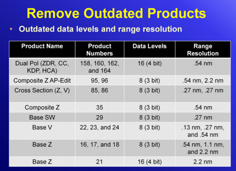
- Obsolete 88D products (mostly low-resolution products) and 88D Alert functionality removed from AWIPS to support RPG Build 18
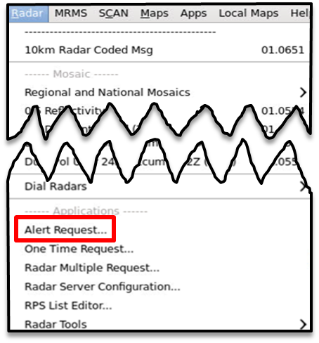
- Radar menu Alert Request submenu removed, editing alert grids, selecting categories to be alerted on, sending Alert Request Message, UAM (SCAN alerts not affected)
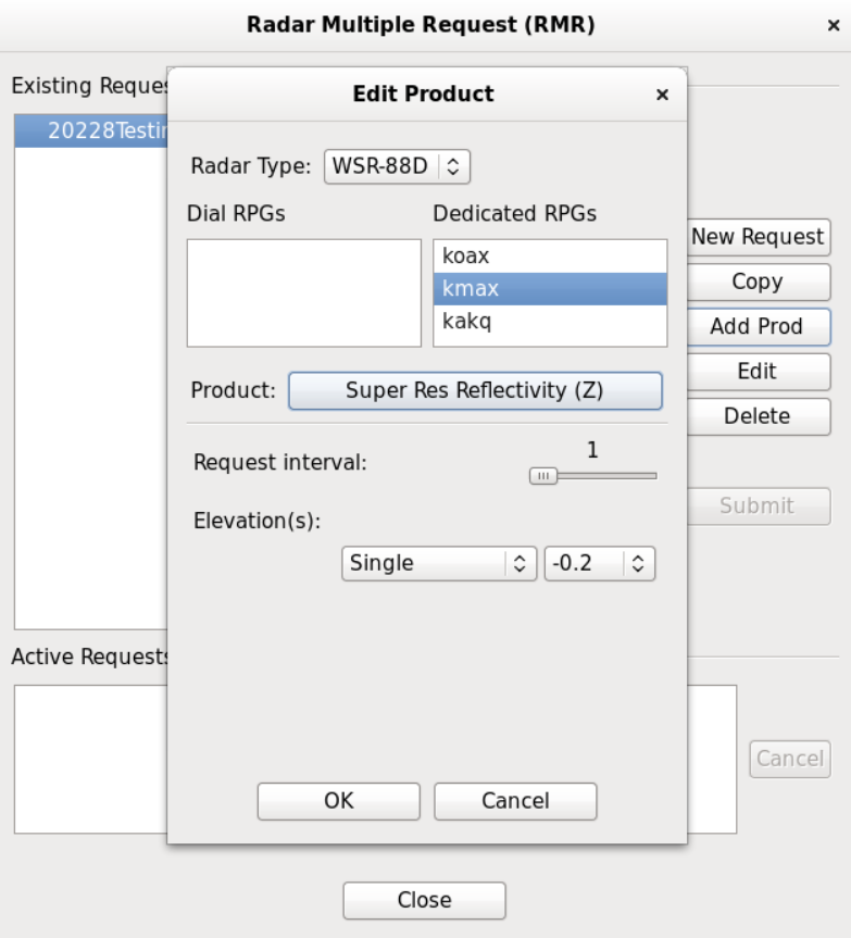
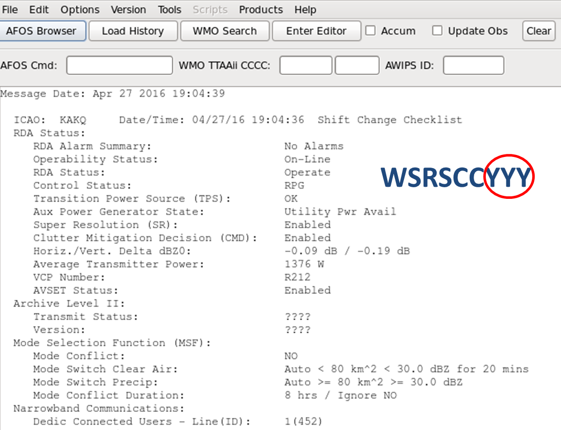
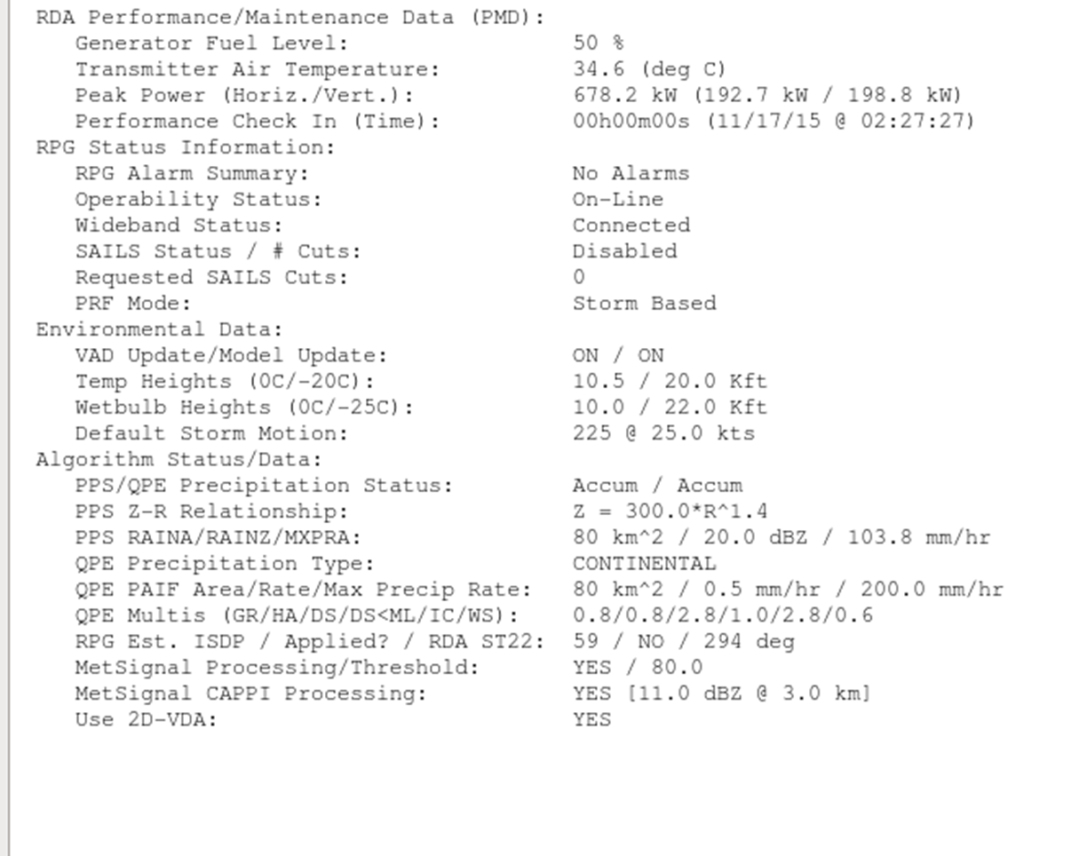
- Radar Shift Change Checklist text product display (image 1, image 2)
- Coming with deployment of RPG Build 18 in Fall 2017
- Required to be completed by forecasters at least once during a shift
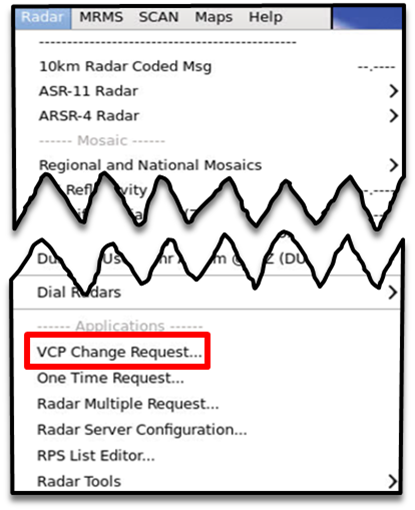
- New VCP Change Request submenu provides tool to turn on/off AVSET, set # of SAILS cuts, and force volume scan restart
- Other recent AWIPS build changes to support RPG 16 and 17 worth mentioning
- RMRs and OTRs with SAILS now displayable (volume scan times for SAILS cuts unique like with dedicated requests)
|
| 16.4.1 |
2016/12 |
AIR |
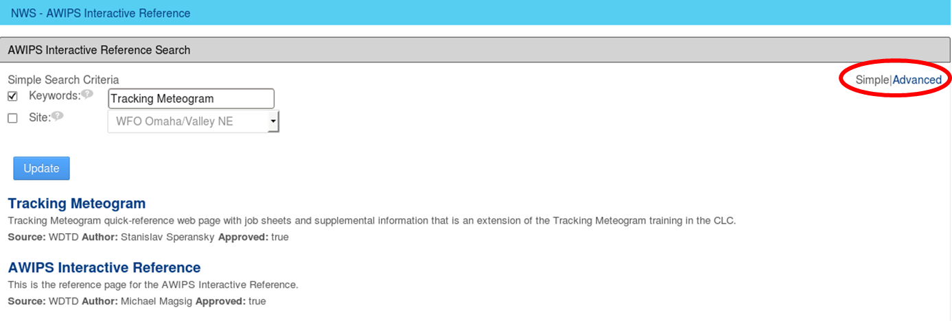
- AWIPS Interactive Reference
- The AWIPS Interactive Reference is a new capability in D2D where you right click in a CAVE product, text, or map legend and access reference materials in the VLab.
|
| 16.2.2 |
2016/09 |
Training |
|
| 16.2.2 |
2016/09 |
CAVE/D2D |
- Damage Path Tool training (Internet CLC), speaker notes PDF (new reference page and job sheets)
- The Damage Path Tool allows forecasters to create real-time damage polygons with comments that can be provided to first responders via the Damage Assessment Toolkit (DAT) server or your local webiste.
- Ensemble Tool (updated reference page and new job sheets)
- The Ensemble Tool was updated to include a distribution viewer that displays probability density functions and cumulative density functions. The update also added a Matrix button capability that allows cycling through volume model family products.
- Menus
- MRMS 5km CZ & RALA and FLASH
- CZ/RALA SBN coming fall 2016, FLASH on SBN later but some may ingest through LDAD
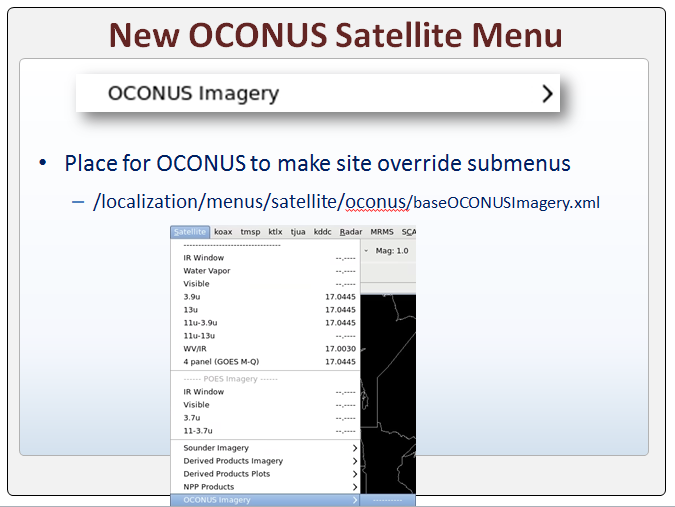
- OCONUS Satellite
- There is a new menu for OCONUS sites to consolidate satellite menu additions.
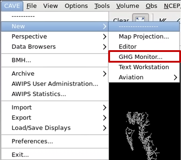
- GHG Monitor CAVE Menu
- GHG can now be launched from the CAVE menu.
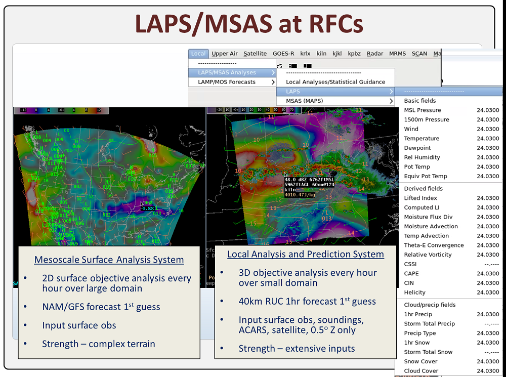
- Laps/MSAS at RFCs
- LAPS and MSAS are now running at RFCs.
|
| 16.2.2 |
2016/09 |
Radar |
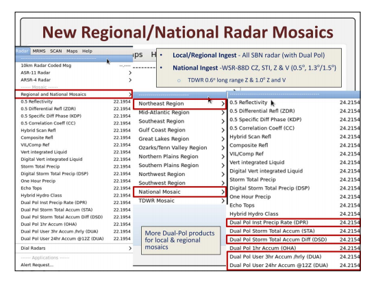
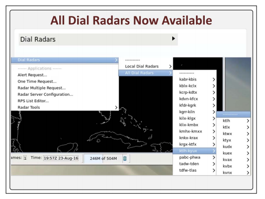
- National/Regional Radar Displays and All Dial Radars
- The Radar menu was updated to include National and Regional radar mosaics and a menu for all dial radars. This supports the national ingest of 6 SBN radar products (CZ, STI, Z & V (0.5 and 1.3/1.5). There are new Dual-Pol menus for the Dual-Pol data ingested from local and regional radars.
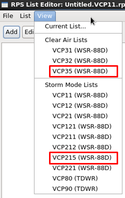
- New VCPs in RPS List Editor
- There are entries for VCP 35 and VCP 215 in preparation for the late 2017 deployment of RPG Build 18.
|
| 16.2.2 |
2016/09 |
Satelitte |
|
| 16.2.2 |
2016/09 |
FFMP |
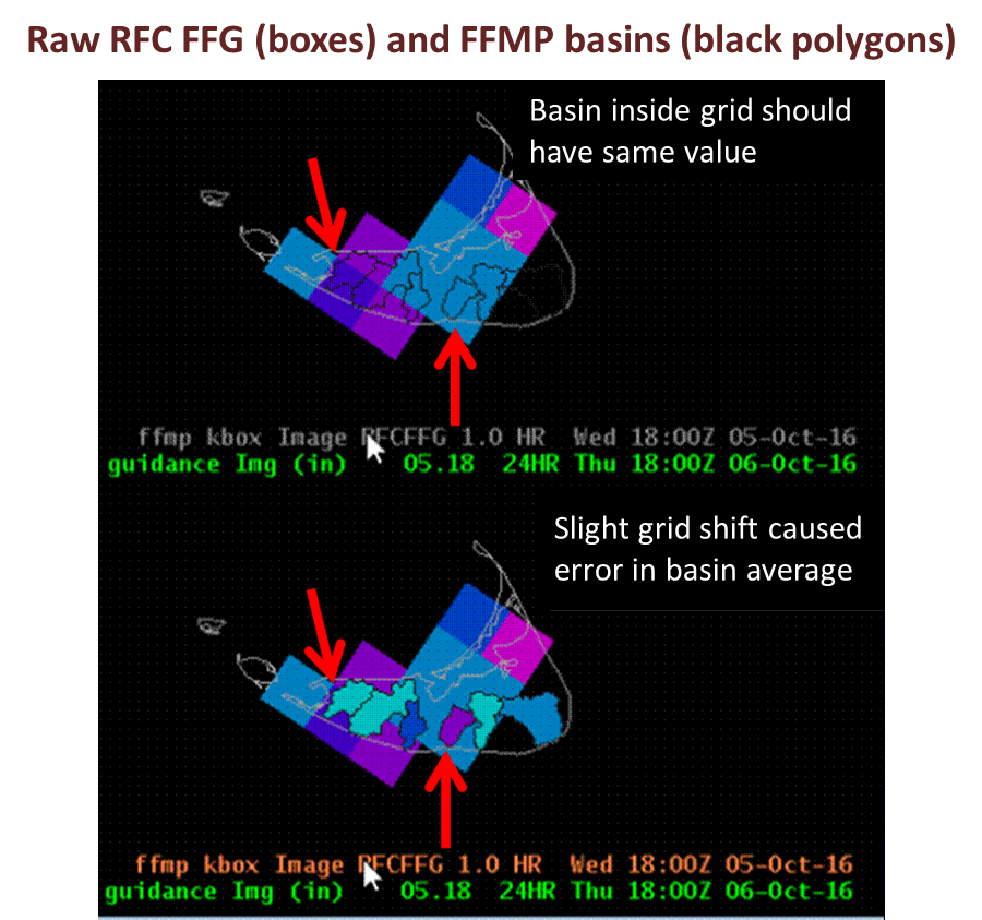
- FFMP Updating Multiple-RFC FFG Fix
- Starting in 16.2.1 in domains with multiple RFCs, when one updated, the others would incorrectly go missing. In 16.2.2 this was fixed, but the data incorrectly updated with older FFG. This is being fixed in 16.2.2 patch 2 which will roll out sometime during deployment of 16.2.2.
|
| 16.2.1 |
2016/08 |
Training |
- AWIPS References from the AWIPS Program
- 16.2.1 Informational Overview (CLC 11min training [Internet], speaker notes PDF)
- Note: The numerous bug fixes and some other enhancements capabilities not covered in the training are documented in the 16.2.1 Release Notes and NIC3.1 Release Notes in the AWIPS References from the AWIPS Program section above.
|
| 16.2.1 |
2016/08 |
MRMS/ARI/FFMP |
|
| 16.2.1 |
2016/08 |
CAVE/D2D |
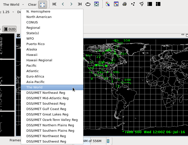
- New D2D map scales (see Scales pullout in CAVE)
- There are numerous map scales that have been added including world views and regional DSS scales.
- National/regional warning plots (Obs menu)
- There are new national and regional warning plots to be able to monitor warnings throughout the U.S.
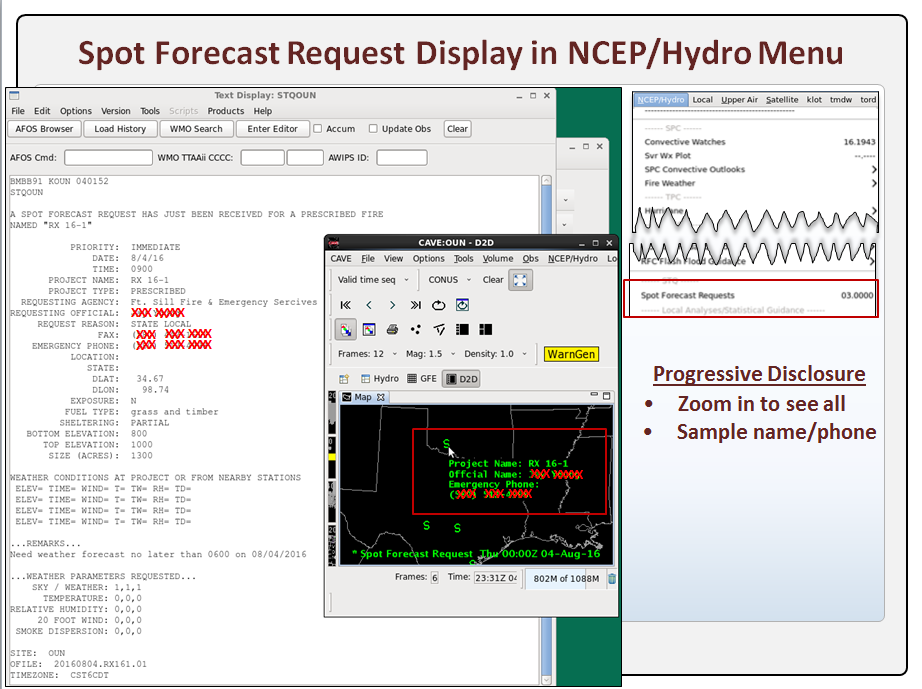
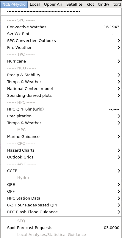
- D2D spot forecast overlay (NCEP/Hydro menu)
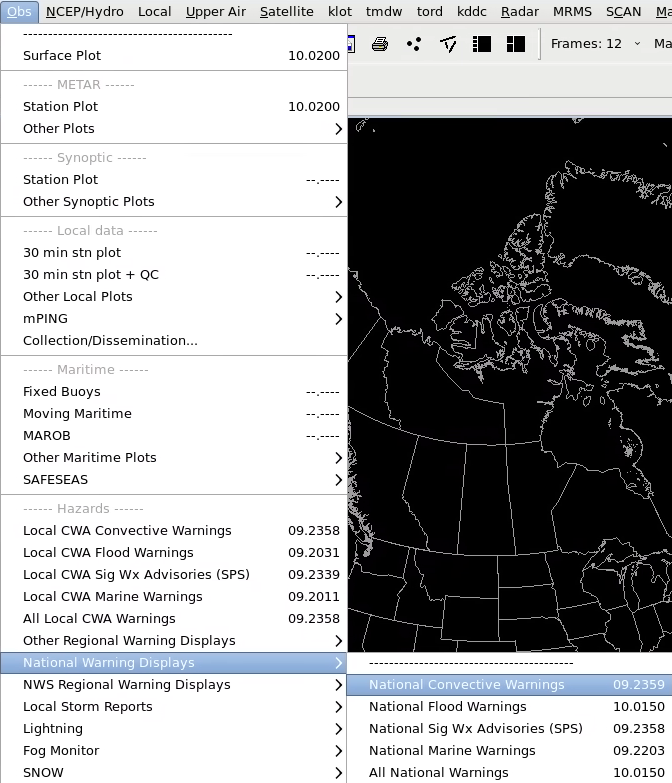
- There is a new graphic to display spot forecasts from the NCEP/Hydro menu.
|
| 16.2.1 |
2016/08 |
Radar |
- All-tilts keyboard shortcut for top of most recent volume scan - see reference page for updates and jobsheet
- Keyboard shortcuts were added to jump to the top and bottom of the most recent complete volume scan.
|
| 16.2.1 |
2016/08 |
Satelitte |
- Satellite Combination Daylight Transition capability - see reference page for job sheet
- You can combine two satellite images and configure them to blend together at sunrise and sunset as daylight transitions.
|
| 16.1.2 |
2016/02 |
CAVE/D2D |
- Tracking Meteogram reference page - updated training and job sheets with improvements to calculations
- The D2D tracking meteogram will use a 100x100 grid and some new techniques to sample the circles instead of the original 20x20 grid to create statistics on image grids. This should prevent undersampling and oversampling and allow for operations like Sum for total lightning trends.
|
| 16.1.2 |
2016/02 |
Radar |
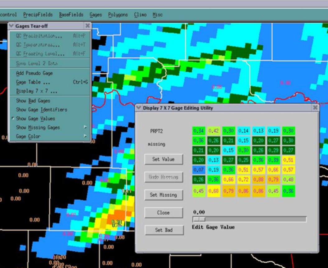
- Dual-Pol DPR in FFMP Fixed
- DPR ingest in FFMP has been incorrect, but it is fixed after 16.2.1 patch 1 (note HPE mosaic has been Dual-Pol since 14.3.1 and has no problems).
|
| 16.1.1 |
2016/01 |
Training |
|
| 16.1.1 |
2016/01 |
CAVE/D2D |
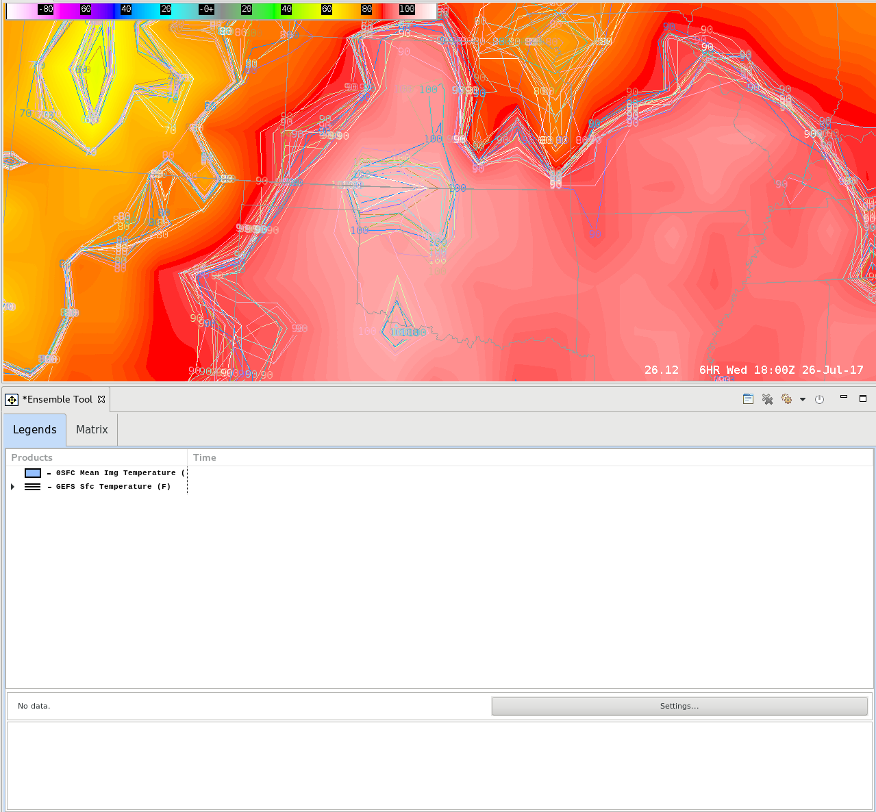
- Ensemble Tool reference page (with job sheet)
- A new D2D tool has been designed to create derived plots from individual model members (WFOs only have access to GEFS temperature and precip ensemble members).
- mPING reference page (with job sheet)
- The crowd-source mPING surface observations can be displayed in D2D if you configure the ingest through LDAD.
- Boundary Tool reference page (with job sheet)
- The Boundary Tool was designed for Aviation Weather Center forecasters to create simple boundary annotations in D2D. The Boundary Tool is similar to other line tools in D2D, except the boundaries can be cleared and reloaded.
- National Blend of Global Models
- New National Model Blend grid data is now being ingested into 16.1.1. The data can be viewed from the Volume Browser under the Sources->SfcGrid->NationalBlend, but the ingest into GFE is dependent on downloading the latest NIC from the local applications registry. The GFE components are planned to become baselined in 16.2.2. For more information on the National Model Blend, see the COMET training on the METED site or contact your local GFE focal point.
|
| 16.1.1 |
2016/01 |
Radar |
|
| 16.1.1 |
2016/01 |
MRMS |
- MRMS All Tilts reference page (with job sheets)
- If you ingest the data through LDAD you can display MRMS Reflectivity Cube grid data in an all-layer all-tilts like way.
- All-Layer Grid reference page bonus!: The discovery of how All-Tilts MRMS works has allowed creating All-Layer all-tilts like products from any existing grid bundles.
|
| 15.1.1 |
2015/09 |
CAVE/D2D |
- Tracking Meteogram Reference Page - see reference page for CLC course "AWIPS-2 Tracking Meteogram" and jobsheet access
- New D2D tool to track features and make time trends of satellite, radar, grid image, and lightning density data. Also monitor time trends at a single location that updates dynamically as you move the point.
|
| 14.3.1 |
2015/02 |
Radar |
- Dual-Pol HPE
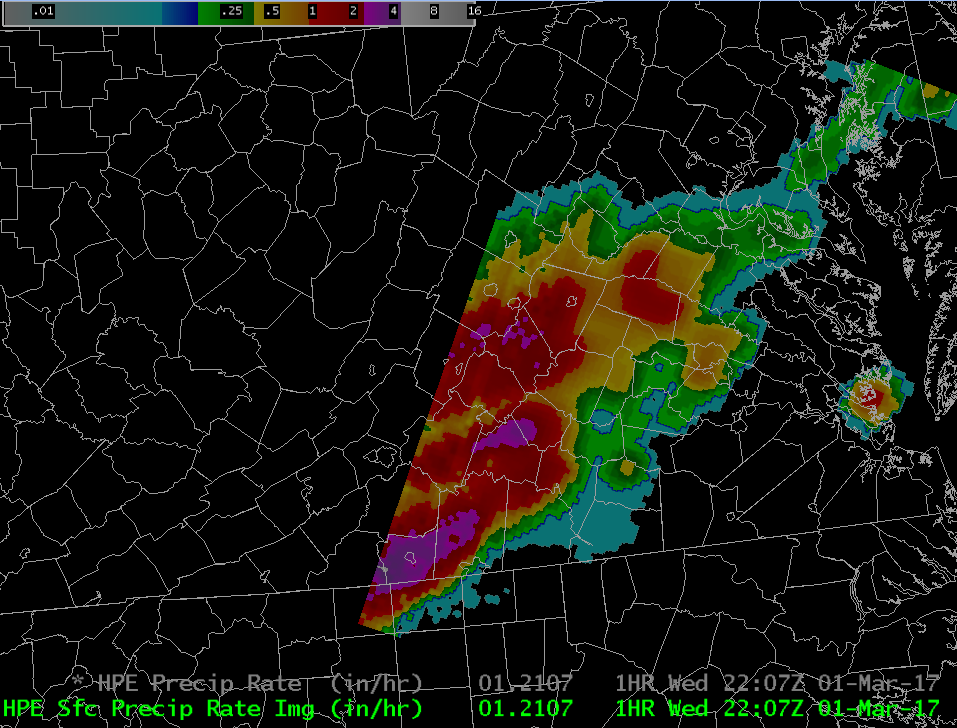
- The mosaic precip-source HPE was changed to use Dual-Pol DPR as input (instead of Legacy DHR) and special overlays were added to FFMP and the volume browser to display the source and biases used in Bias HPE. The original training to support this was the "Incorporating Dual-Pol HPE/Bias HPE Into Flash Flood Decision Making" module which also had an FFMP/HPE Reference PDF. This training has been updated and split into the following module that is now part of the Warning Operations Course (WOC) Flash Flood Track:
- High-Resolution Precipitation Estimator (HPE) and Bias HPE (CLC search string: HPE)
|
| 14.3.1 |
2015/02 |
Flash Flood |
- The AWIPS tools for flash flooding have been fully incorporated into the WOC Flash Flood Track. Forecasters should refer to the following two courses to incorporate the AWIPS changes into operations:
- IC Flash Flood 2: Flash Flood Forecasting Tools (2018 course snapshot)
- Ensemble Situational Awareness Table: NAEFS Anomaly & Percentile Data
- Ensemble Situational Awareness Table: GEFS M-Climate Data
- Introduction to Average Recurrence Intervals (ARIs) in AWIPS
- Web-Based Tools for Flash Flooding
- Introduction to the High-Resolution Precipitation Nowcaster (HPN)
- Using the HPN in AWIPS
- Using the Virtual Gauge Basins (VGBs) in FFMP
- IC Flash Flood 3: Flash Flood Warning Best Practices (2018 course snapshot)
- Choosing Your Precipitation & Guidance Sources
- Warning Operations Using FFMP
- FLASH Best Practices
- Hydro Products Decision Tree
- Flash Flood Warning Fundamentals
- Flash Flood Emergency Overview
|


