


Tracking Meteogram - OCLO
Tracking Meteogram
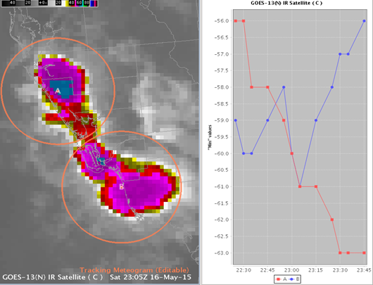
Fig. 1 Tracking meteogram tool loaded over satellite IR for two different storms A and B (see circle center and line legend).
Training Job Sheets (click on "html" for web page layout with image links or "PDF" for PDF viewing with images embedded with instruction)
- Jobsheets are extension of the "AWIPS Tracking Meteogram Tool Training" posted to (LMS - Internet, speaker notes PDF) in Feb 2016.
- All Tracking Meteogram Jobsheets (html, PDF)
- Jobsheet 1: Track Cloud-Top Temperatures and Load Additional Meteograms (html, PDF)
- Jobsheet 2: Create Meteograms From a Paired Radar Product (html, PDF)
- Jobsheet 3: Create Meteograms From Multiple Stacked Grid Images and Use Snap All Points to This Location (html, PDF)
- Jobsheet 4: Track Total Lightning Density Trends in Convective Storms (html, PDF)
Overview
- Track circles with the tool to create time trend of radar, satellite, grid image, and total lightning density
- Does not work with contours, wind barbs, station plots
- Apply 8 math operators (max, min, sum, mean, median, standard deviation, range difference, and amplitude)
- Range difference: absolute value of max difference (good for rotation and divergence delta Vs in radar)
- Amplitude: max absolue value (good for damaging wind in base velocity data)
- Tracking Meteogram draws a 100x100 grid box and samples the raw data (before AWIPS 16.1.2, 20x20 grid box and sampled pixels drawn on screen)
Refresher Commands
- Loading - select Tracking Meteogram Tool from Tools menu
- Change Circle Size - scroll wheel while mouse pointer is on circle
- Configure Meteogram - right click on circle to launch configuration menu
- Configure trend graph properties - right click on time trend
Usage Tips
- Avoid having circles extend outside of data domains (grid domains for high-res models in particular) as they can corrupt your calculations.
Limitations
- Breaks keyboard shortcuts like Del key on keypad for toggling radar
- Workaround: click on time trend plot then click back on map editor to restore keyboard shortcuts
- Does not work with All-Tilts
- Cannot save in procedures and cannot save plot configuration changes
Contact
- Samantha.Boyd@noaa.gov