


MRMS All Tilts - OCLO
MRMS All Tilts
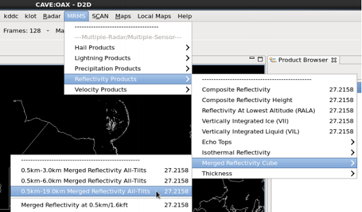
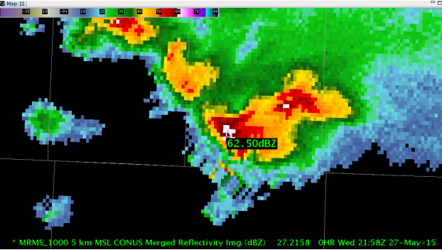
Fig. 1 5km MSL MRMS merged reflectivity cube displayed from the 0.5-19km all tilts MRMS menu.
Training Job Sheets (click on "html" for web page layout with image links or "PDF" for PDF viewing with images embedded with instruction)
- MRMS All-Tilts Loading and Navigating (html, PDF)
- MRMS All-Tilts referenced in 16.1.1 Informational Overview (LMS - Internet, speaker notes PDF)
Overview:
- MRMS has implemented its own all-tilts like display with 128 frames of constant altitude (MSL) gridded reflectivity layers from the 1kmx1km 2min resolution Merged Reflectivity Cube mosaic which can be brought in through LDAD.
Refresher Commands:
- Loading - select from the 0.5km-3.0km, 0.5km-6.0km, and 0.5-19.0km All-Tilts menus in MRMS->Reflectivity Products->Merged Reflectivity Cube.
Usage Tips
- How it is Best Used
- MRMS All-Tilts Reflectivity - used to monitor 3D reflectivity structure for hail, winter weather, precipitation over larger areas with multiple radars, similar to FSI but instead of single radar, the data is from a multi-radar mosaic
- D2D All-Tilts - used for multi-variable (Z, Zdr, V, CC, KDP, SW, algorithms) highest resolution and most responsive radar analysis with full CAVE integration (map overlays, standard environmental data packages, popup Skew-T, WarnGen, etc.)
- Four-Dimensional Storm-Cell Investigator (FSI) - used for single-radar multi-variable (Z, Zdr, V, CC, KDP, SW) dynamic horizontal and vertical displays separate from CAVE
- Choose a shallower layer (e.g. 0.5km-3km) if you want a longer duration of data in your 128 frames of data (note the data is 2 min resolution).
- To asses the height of the layer pay attention to the height label in the bottom left part of the text legend (see Fig. 1).
- The reflectivity layers start at 0.5km MSL, which can be below ground in many locations, so anticipate areas of no data beneath storms when the ground elevation is above 0.5km MSL or when precipitation is at long ranges with high 0.5 degree beam heights.
- Keyboard Shortcuts (same as D2D all tilts)
- left/right arrow keys – backward and forward in time
- up/down arrow keys – vertical navigation
- Ctrl + right arrow keys – most recent frame at highest height
- Ctrl + left arrow keys – oldest frame at any height
- Ctrl + up arrow keys – highest frame at time of data displayed
- Ctrl + down arrow keys – lowest frame at time of data displayed
Limitations
- Your local site must configure the ingest through LDAD to be able to see the data.
- Only reflectivity data is available for MRMS All Tilts.
Contact
- nws.wdtd.awips@noaa.gov