


Canadian Radar - OCLO
Canadian Radar Overview
Overview
23.2.1 implemented the ingest and display of Canadian radar data though the SBN (NMC channel) distribution of radar data should occur before the end of 2024. The radar data is very similar to the WSR-88D data except that the Volume Coverage Patterns (VCP) are different, the data can be a little more noisy than the WSR-88D, and there is no hydro classification algorithm for the Dual Pol data. Canada has just converted all their C-band radars to S-band radars, and the NWS only ingests the Canadian S-band radars. The convention for Canadian radar naming is to begin with "ca" (from Canada), followed by "s" for S-Band, then finally with two letters for the radar name identifier (e.g. Woodlands, Manitoba is denoted "wl", giving us a final radar name of caswl).
NOTE: Due to data limits, 24 of the 32 total Canadian S-band radars are being distributed. Most of the available radars are focused along the U.S./Canadian border. A complete list of available radar site are shown below.
Jump to a section:
Specs | Canadian Spec Table | VCP and Elevation Angles Table | WSR-88D Comparison Table | Radar 4-Panel Example with Sampling | Loading the Canadian Mosaic Jobsheet (opens in new tab)
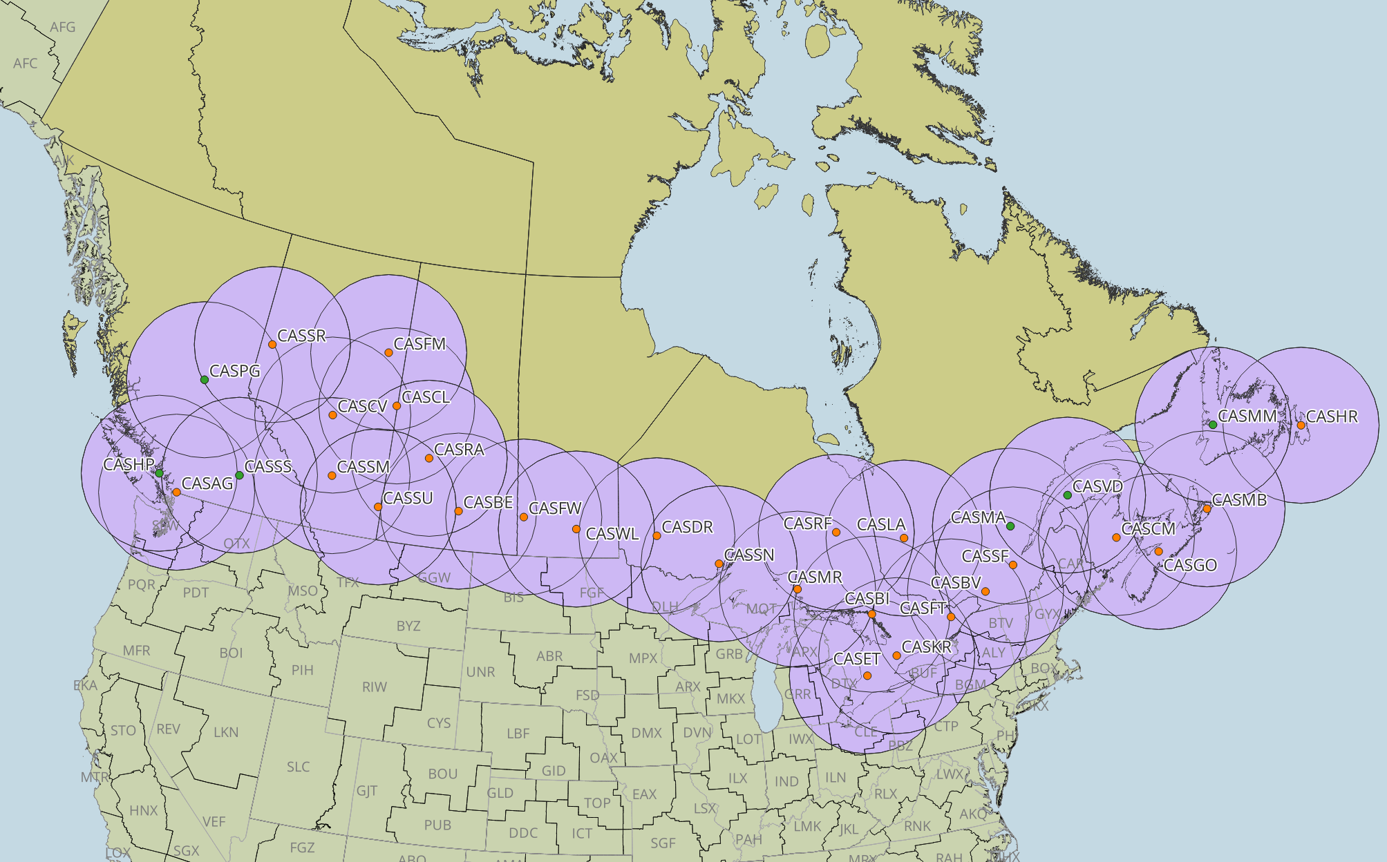
Overview images of the Canadian Radar mosaic.
Canadian S-Band Radar Specs:
- 32 radars covering most of Canada's populated areas (note that casts is a training/research radar and is generally not available)
- Radar data distribution on the SBN is anticipated before the end of 2024, however due to data rate limitations only 24 radar sites are being distributed
- S-band radar uses 5 characters (e.g. casbv) with the last two letters denoting the location/identifier
- S-band operates at 2.7-2.9 GHz and sometimes external sources will interfere on that wavelength
- Volume scans contain 17 slices in 6 minutes and are acquired from top to bottom
- In AWIPS, Canadian radar metadata is stored in the odim metadata table and odim hdf5 folder
- A quiet summer pattern is ~2.5GB-4GB/day/radar with 24 hours of data stored (83GB/day total)
- Data storage within AWIPS:
- Processed data is stored in: /awips2/edex/hdf5/odim/[radar name]/
- Contains 24 hours of data (82GB *.h5 files per day)
- Metadata is stored in the odim metadata table
- Raw data is stored in: /data_store/manual/odim/[date]/[hour]/
- Contains raw hdf5 input data files (size: ~3.5GB/hr) that can be ingested by copying into the manual endpoint
- Processed data is stored in: /awips2/edex/hdf5/odim/[radar name]/
- 2 volume scans
- Default: 0.4, 0.8, 1.2, 1.6, 2.1, 2.7, 3.5, 4.4, 5.3, 6.4, 7.7, 9.4, 11.3, 13.7, 16.6, 20.2, and 24.4 degrees
- Mountain: -0.3 OR 0.0, 0.4, 0.9, 1.5, 2.1, 2.7, 3.5, 4.4, 5.3, 6.4, 7.7, 9.4, 11.3, 13.7, 16.6, 20.2, and 24.4 degrees
- casvd and casss have -0.3 degrees as the lowest tilt
- caspg, casmm, cashp, and casma have 0.0 degrees as the lowest tilt
For more information about Canadian radar data see the Wiki page or the Environment and Climate Change Canada (ECCC) site.
To view some archived radar data, see the Canadian Historical Radar Data viewer.
Helpful Spec Tables:
At a glance
| Canadian Radar Specs At-A-Glance | |||
| Number of VCPs | 2 (Default and Mountain) | VCP Scan Slices | 17 |
| VCP Scan Time | 6 minutes | VCP Scan Orientation | Top (highest elevation) to bottom (lowest elevation) |
| Reflectivity Range | 330km | Beamwidth (Azimuthal Resolution) | 0.5° for lowest six tilts, 1° for tilts 1.0°-17° |
| Velocity Range | 330km | Gate Depth (Range Resolution) | 500m |
| Precipitation Range | 330km | Lowest Tilts | Typically 0.4°; -0.3° for casvd and casss; 0.0° for caspg, casmm, cashp, and casma |
| Processing | Doppler processing for the first 110km and conventional processing for beyond 110km* | Latency to Receiving in AWIPS | 1 to 6 minutes |
*A discontinuity in precipitation can sometimes appear at and beyond 110km from the radar due to the difference in processing methods
VCP Elevation Angles
| Canadian Elevation Angles | ||
| DS # | Default | Mountain |
| 1 | 24.4 | 24.4 |
| 2 | 20.2 | 20.2 |
| 3 | 16.6 | 16.6 |
| 4 | 13.7 | 13.7 |
| 5 | 11.3 | 11.3 |
| 6 | 9.4 | 9.4 |
| 7 | 7.7 | 7.7 |
| 8 | 6.4 | 6.4 |
| 9 | 5.3 | 5.3 |
| 10 | 4.4 | 4.4 |
| 11 | 3.5 | 3.5 |
| 12 | 2.7 | 2.7 |
| 13 | 2.1 | 2.1 |
| 14 | 1.6 | 1.5 |
| 15 | 1.2 | 0.9 |
| 16 | 0.8 | 0.4 |
| 17 | 0.4 | -0.3 or 0.0 |
List of available sites on the SBN
| Site ID | |
| CASSS | CASAG |
| CASFM | CASSM |
| CASSU | CASBE |
| CASFW | CASWL |
| CASDR | CASMR |
| CASET | CASBI |
| CASKR | CASFT |
| CASSN | CASBV |
| CASSF | CASMA |
| CASVD | CASCM |
| CASGO | CASMB |
| CASMM | CASHR |
Canadian Radars versus WSR-88D
| Canadian Radar versus WSR-88D | ||
| Category | Canadian Radar | WSR-88D |
| Band | S-Band | S-Band |
| Naming convention | 5 character names beginning with "cas" (e.g. casbv) | 4 character names (e.g. kmux) |
| Volume Scan Slices | 17 | VCP Dependent (ranges from 5 to 15) |
| Volume Scan Time | 6 minutes | 8-10 minutes for clear air modes, 4-7 minutes for precipitation modes |
| Volume Scan Orientation | Go from top (highest elevation) to bottom (lowest) | Go from bottom (lowest elevation) to top (highest) |
| Number of VCP Volume Scans | 2 | 7 |
| Types of VCP Modes |
Precipitation mode(typically Normal and Mountain Strategy); no clear air mode |
Clear air and Precipitation Mode |
| Lowest Tilt(s) | Typically 0.4°; -0.3° for casvd and casss; 0.0° for caspg, casmm, cashp, and casma | 0.5° with 18 sites having supplemental scans going down as low as -0.2° |
| Reflectivity Range | Up to 330km | Up to 460km |
| Velocity Range | 330km | 230km for normal resolution, 300km for super resolution |
| Precip Range | 330km | 260km |
| Beamwidth (Azimuthal Resolution) | 0.5° for lowest six tilts, 1° for tilts 1.0°-17° | 1° for batch and higher tilts, 0.5° for split cuts (super resolution) |
| Gate Depth (Range Resolution) | 500m | 250m |
| Latency | Varies from 1 to 6 minutes | Negligible |
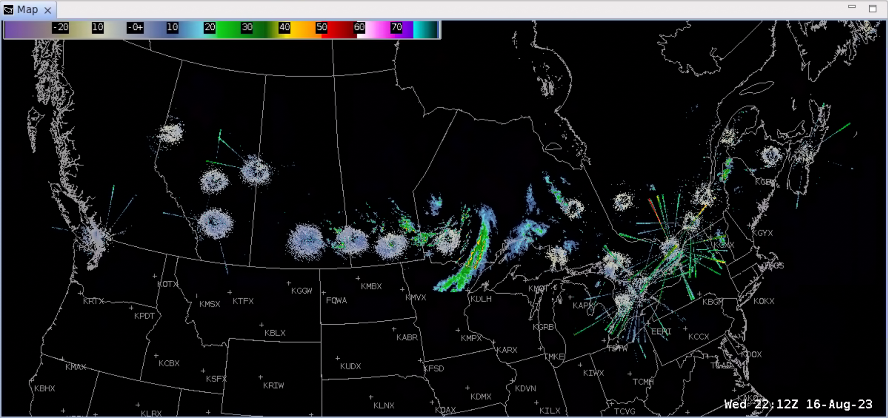
Example of data with sampling
