


Damage Path Tool - OCLO
Damage Path Tool
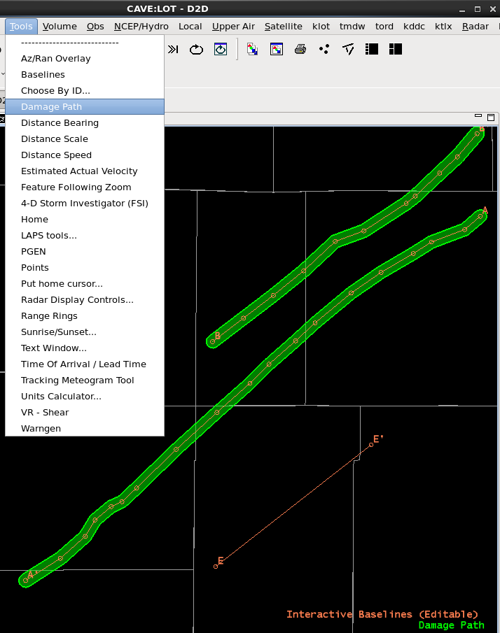
Fig. 1 Damage Path Tool with tornado tracks created from baselines A and B.
Training Job Sheets (click on "html" for web page layout with image links or "PDF" for PDF viewing with images embedded with instruction)
- Jobsheets are extension of the Damage Path Tool Training (LMS - Internet; speaker notes PDF).
Overview
- Create damage path polygons with comments for Preliminary Tornado, Significant Wind Damage, Hail, Flood, Extreme Ice/Snow, and Other Man-Made/Natural Hazard and distribute to the DAT server (FEMA) or to your local web page
- General workflow
- Create a polygon using DPT (simple box or a tornado path from a baseline)
- Set properties to assign Hazard Type, Name, Event Time, and Comments (<500 characters)
- Export to LDAD (FEMA) or export to a file to share with your local EMs, etc.
- requires AWIPS Focal Point to check out DamagePathToDat from the SCP
Refresher Commands
- Loading - select Damage Path from Tools menu
- Right-Click on CAVE Editor with Damage Path Loaded
- Add Polygon - adds a polygon to the display
- Right-Click on Polygon
- Add Vertex - adds vertex (can also just middle click on polygon line)
- Delete Polygon - deletes DPT polygon (warning: if not saved as a file you can't get it back)
- Set Properties - select Hazard Type and specify Name, Event Time, and Comments
- Right-Click on Damage Path
- New Tornado Path From Baseline - select baseline to use to create default tornado polygon that assigns width according to uncertainty from radar range
- requires Damage Path (Editable) - middle click on Damage Path text legend to make Editable
- Export to LDAD - sends all damage paths in display to LDAD to be pushed to the DAT server for FEMA (comments must be < 500 characters)
- Export to File - saves geojson file for local distribution (email/website) for local EMs, etc.
- Import from File - loads a saved file
- Change Color - changes color of display in CAVE (not included in distributed product)
- New Tornado Path From Baseline - select baseline to use to create default tornado polygon that assigns width according to uncertainty from radar range
Usage Tips
- For tornado paths
- trace vortex in radar data using vertices in a baseline
- set your home (from Tools menu) to be your radar location
- make Damage Path legend text editable
- select baseline from right click and selecting New Tornado Path from Baseline
- remember tracks should be wider at longer ranges due to uncertainty in position increasing with range from the radar
- the "New Tornado Path From Baseline" menu option does does this for you
- Comments for tracks exported to the DAT server must be less than 500 characters due to DAT server limitation
- Coordinate with local management to assess when to use, staffing, and coordinating with stakeholders before creating damage path products
Limitations
- Effective products require preparation, staffing, and coordinating with stakeholders
- DAT server will truncate comments to 500 characters, so keep it short
Configuration/Supplemental Information (AWIPS Focal Point)
- The Damage Path Tool option to "Export to LDAD" will not work by default with a 16.2.2 installation. Your AWIPS Focal Point will need to check out the DamagePathToDat program from the SCP (very easy install).
Contact
- nws.wdtd.awips@noaa.gov