


Impact Based Warnings (IBW) SVR/TOR/SPS Jobsheet - OCLO
Default Jobsheet Viewer
Purpose:
This jobsheet is for forecasters to become familiar with the new IBW templates for SVR, TOR, and SPSs after taking the "Warning Content: Impact Based Warnings" and "SPS for Near Severe Storms" training in the CLC. While no warnings or statements are sent in the following steps, it is best to enter Practice Mode if doing this on a live AWIPS to prevent accidental release of products.Tasks:
Part 1: Warning text changes for SVR
- If on a live AWIPS, enter Practice Mode.
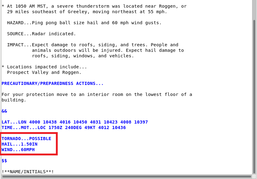
- Open WarnGen and prepare a SVR warning with the following criteria:
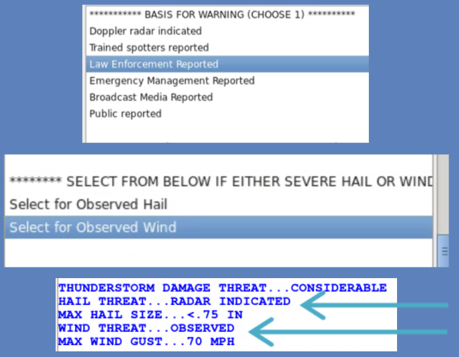
- Doppler radar indicated, 60 mph wind, ping pong size hail, tornado possible
- Create text.
- Notice the new tags at the bottom of the warning, including HAIL THREAT, MAX HAIL SIZE, WIND THREAT, and MAX WIND GUST.
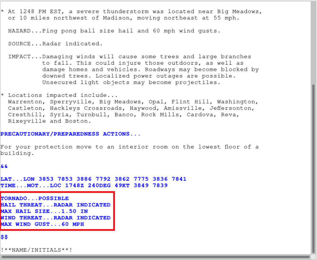
- Cancel the warning text and return back to the WarnGen window. Now choose the following criteria instead:
- Doppler radar indicated, 60 mph wind, golf ball size hail, tornado possible.
- Create text.
- Notice now, along with the previously mentioned added tags, there is THUNDERSTORM DAMAGE THREAT... CONSIDERABLE. This tag will automatically trigger for wind greater than or equal to 70 mph OR hail greater than or equal to 1.75 in.
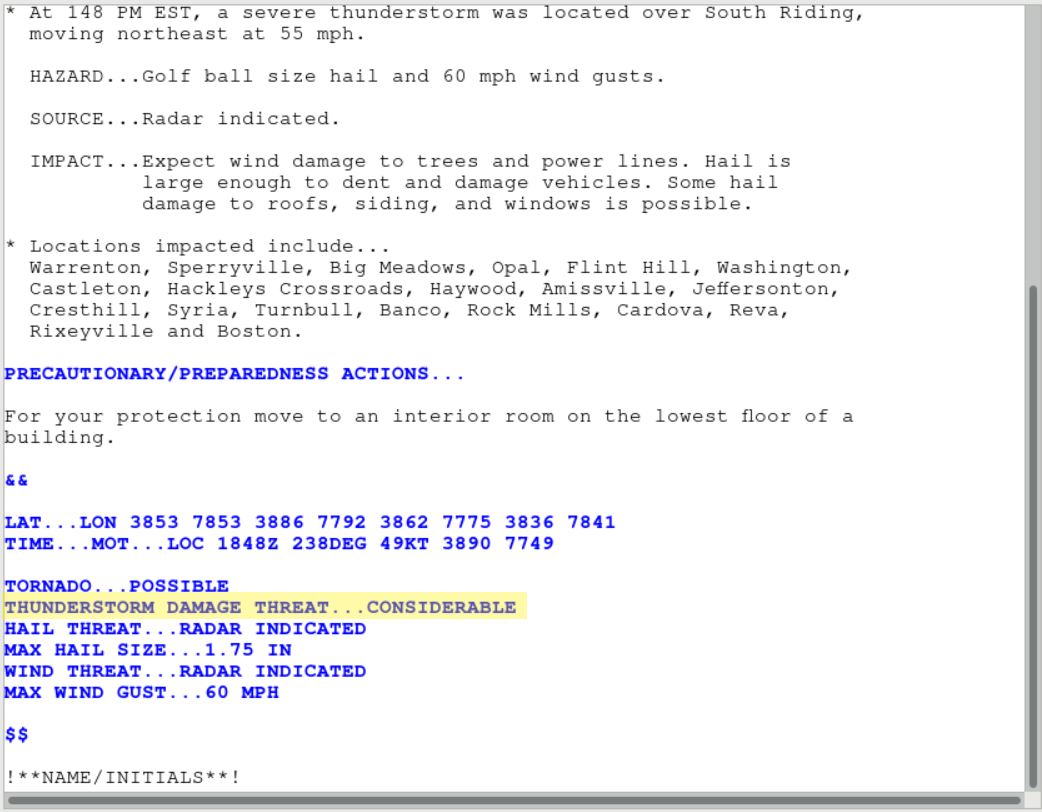
- Cancel the warning text and return back to the WarnGen window. Now choose the following criteria instead:
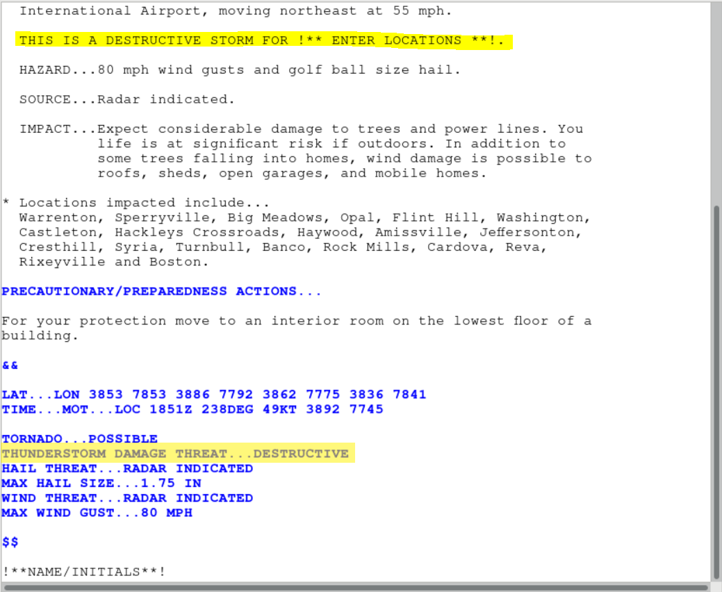
- Doppler radar indicated, 80 mph wind, golf ball size hail, tornado possible.
- Create text.
- Notice now THIS IS A DESTRUCTIVE STORM FOR !** ENTER LOCATIONS **! Near the top of the warning text, and THUNDERSTORM DAMAGE THREAT...DESTRUCTIVE included in the tags at the bottom. This “destructive” tag will automatically trigger when the wind threat is greater than or equal to 80 mph or the hail threat is greater than or equal to 2.75 in. The destructive tag in SVR warnings is unique in triggering Wireless Emergency Alerts.
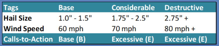
- Here is a summary of the thresholds for the IBW SVR tags along with their calls to action:
- Note, in the IBW format, the tags at the bottom will reflect whether the threat is radar indicated or observed. Also note that hail and wind have separate selections for observed hail and observed wind, so you can specify one type observed and the other type radar indicated (e.g. observed 70mph and radar indicated <0.75").
Part 2: Warning text changes for TOR
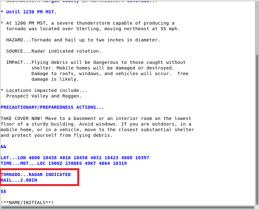
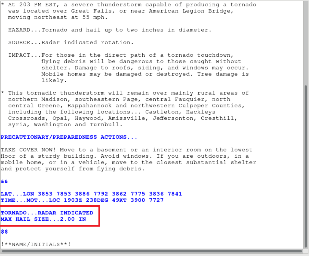
- Open WarnGen and prepare a TOR warning with any criteria.
- Create text.
- Notice in the IBW TOR warning text there is a tag for MAX HAIL SIZE… which does not exist in the Legacy TOR warning text. (Legacy and IBW shown.
- Note that considerable and catastrophic tags for tornado warnings are manually selected whereas for severe thunderstorm warnings, the tags are triggered by the thresholds of hail and wind specified. Also note that while only catastrophic severe tags trigger Wireless Emergency Alerts, base tornado warnings trigger Wireless Emergency Alerts.
Part 3: Product text changes for SPS
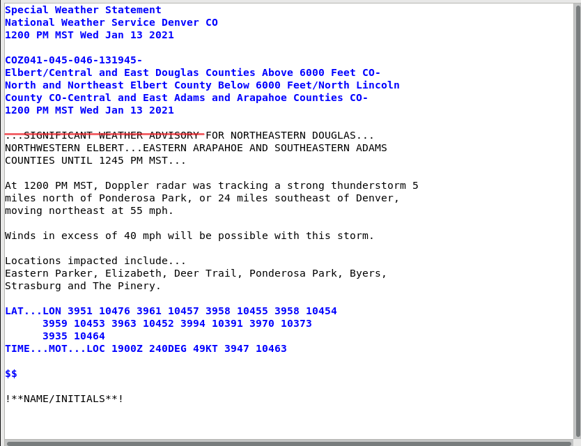
The Special Weather Statement is intended to provide the public with information concerning ongoing or imminent (non-severe) weather hazards requiring a heightened level of awareness or action as in sub-severe thunderstorms producing hail <1", thunderstorm wind gusts 40-57 mph, or landspouts, waterspouts over non-marine zones, or funnel clouds not expected to produce significant damage on the ground). While long-fused SPSs can be generated in GHG, in this jobsheet we will review the IBW tags for a sub-severe application in WarnGen. Note: The previously used "Significant Weather Advisory" will now fall under "Special Weather Statement" in the new format. "Significant Weather Advisory" will no longer be an option in WarnGen.
- Open WarnGen and create a special weather statement. Enter whatever wind/hail criteria is desired.
- Create text.
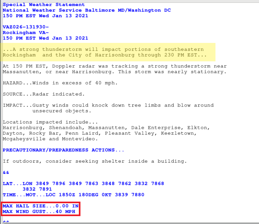
- Notice the lack of the "SIGNIFICANT WEATHER ADVISORY" headline as well as the addition of the MAX HAIL SIZE and MAX WIND GUST tags at the bottom. (Legacy [top] and IBW [bottom] shown below):
- Close the product and return to the WarnGen window. Note that while SPSs have IBW tags, they do not contain VTEC information and cannot be followed up.
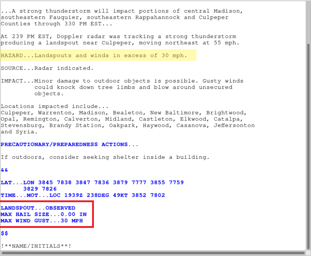
- In the WarnGen GUI, choose "Landspout sighted" from the Landspout/Waterspout section.
- Create text.
- Notice in the SPS text the new IBW tags for MAX HAIL SIZE, MAX WIND GUST, and also LANDSPOUT...OBSERVED. (The same would apply for waterspouts.)
Additional Information Regarding the IBW Format
- Sources: Broadcast media is now an option for the source bullet.
- Wind-driven hail CTA: There is now an additional Call-to-Action (CTA) for “wind-driven hail” instances. (TOR, SVR, SVS)
- Tornado Watches: Tornado watches in SVR/SVS are now located after CTAs and before && (SVR/SVS).
- Mile markers: New limit of 5 mile marker references (TOR, SVR, SVS)
- Tornado emergency selection label: The WarnGen GUI has "TORNADO EMERGENCY! With approval usage through shift supervisor. **REQUIRED**" in the label. Note there is no shift supervisory message in the actual product (TOR).
- Wireless Emergency Alerts (WEAs): There is a new convention for SVR/SVSs to only be activated for a thunderstorm with the "Destructive" tag. For tornado warnings, WEA trigger off "Base", "Considerable", or "Catastrophic".
- SPS impact statement: For SPSs, an "impact statement" will be required for wind or hail. At least one of the following statement should be included (however both can be used, if desired) when an SPS is issued for a wind or hail threat:
- Wind (40 - 57 mph): Gusty winds could knock down tree limbs and blow around unsecured objects.
Hail (Less than 1.00”. Pea (0.25”) to Nickel size (0.88”)): Minor damage to outdoor objects is possible.
- Wind (40 - 57 mph): Gusty winds could knock down tree limbs and blow around unsecured objects.
- Locations impacted: A limit of five mile marker references in the locations impacted section has been implemented.
- NOW: The NOW product should have most of the convective threats removed because the NOW is not supposed to contain references to hail or gusty thunderstorm winds (40mph or above) or duplicate/contradict information contained in the SPS or other watch, warning, and advisory products.