National Blend of Models (NBM) Upgraded to Version 4.3 - MDL
May 27, 2025
National Blend of Models (NBM) Upgraded to Version 4.3
On May 27, 2025, NOAA’s National Weather Service (NWS) upgraded its operational product, the National Blend of Models (NBM) — a nationally-consistent and calibrated suite of forecast products generated by combining numerical weather prediction and post-processed data. This upgrade (version 4.3) primarily focused on improvements to the NBM Tropical Cyclone Feature-Matched wind speed product and incorporated updates provided by the Storm Prediction Center (SPC) to the probabilistic severe weather products. While the Tropical Feature Matching product was originally planned to be part of the planned NBMv5.0 upgrade in April 2026, the National Hurricane Center expressed its desire to have these NBM tropical wind improvements placed into the operational job stream for the 2025 tropical season. Given the urgency of this request, it was decided to implement an intermediate version (NBMv4.3) prior to implementing NBMv5.0. Two noteworthy enhancements were made to NBMv4.3
Tropical Feature Matching 10m wind enhancements:
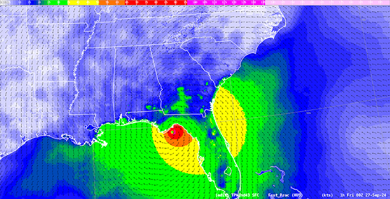
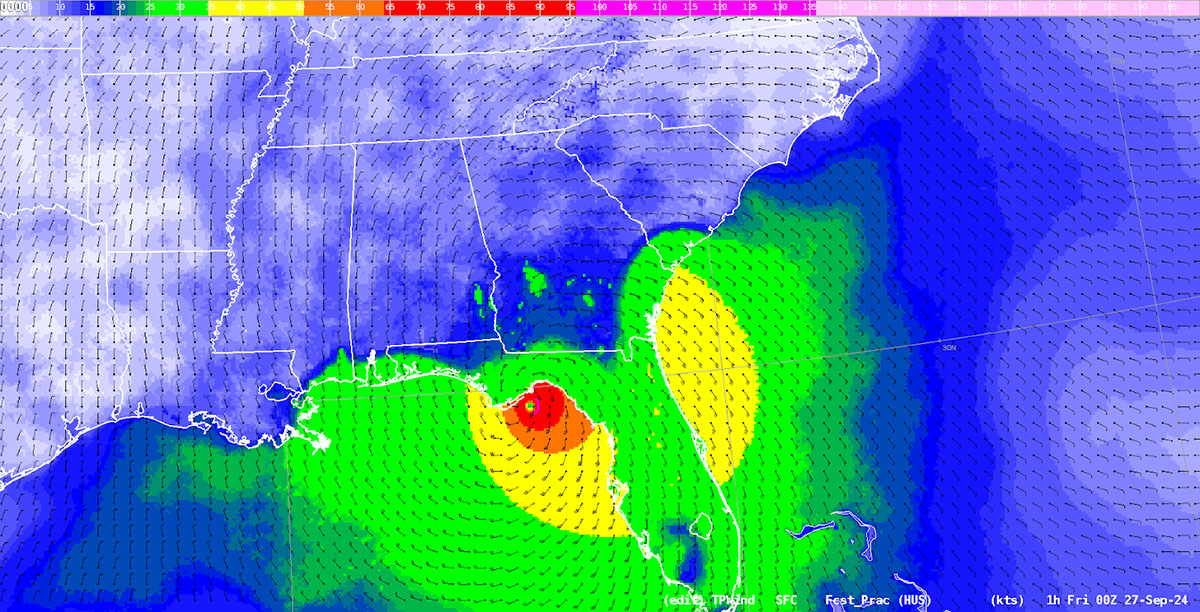
- Land/Water adjustments of Direct Model Output (DMO) wind speed and u-v wind components when displaced to match the National Weather Service’s Tropical Cyclone Wind Model’s (WTCM) center. These adjustments are determined using the surface roughness values from the Hurricane Analysis and Forecast System (HAFS). The goal is to remove unrealistic fast speeds over land (and resulting discontinuities) when a wind field around a storm is adjusted. The two figures below demonstrate the improvement to the 10m wind speed field before (Figure 1a) and after (Figure 1b) the change.
- Swapping of the existing NBM tropical wind direction with the derived 10m wind direction from tropical feature-matched 10m u- and v- components.

SPC probabilistic severe weather products enhancements:
Probabilistic severe hazards for tornado, hail, and wind are expanded out to Day 2 and are now calibrated from a Global Ensemble Forecast System (GEFS) and High Resolution Ensemble Forecast (HREF) blend - usage of the Short-Range Ensemble Forecast (SREF) system to compute these probabilities has been terminated. New cycles for these severe hazards are 0000 UTC and 1200 UTC to complement the existing products available from the 0300, 0600, 1500, and 1800 UTC cycles.
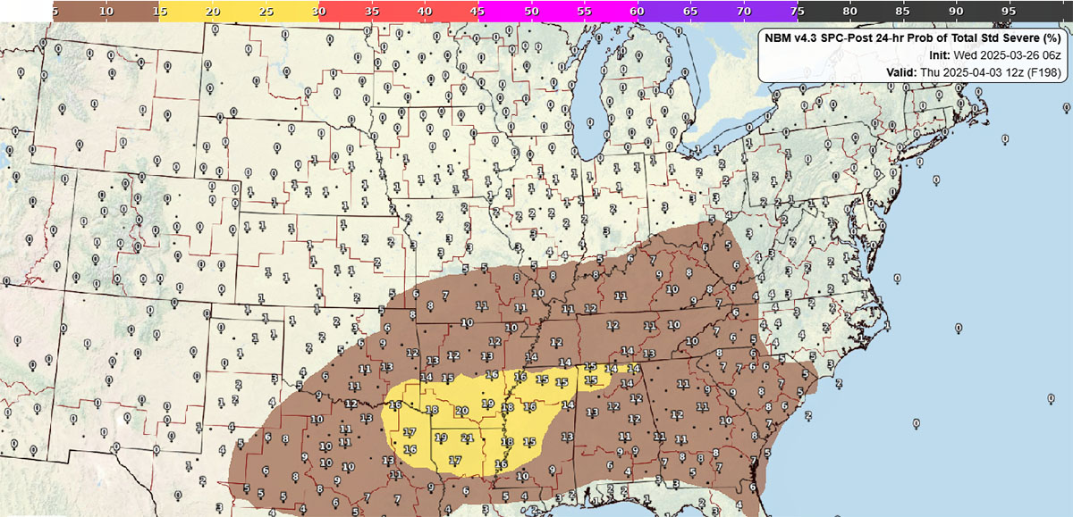
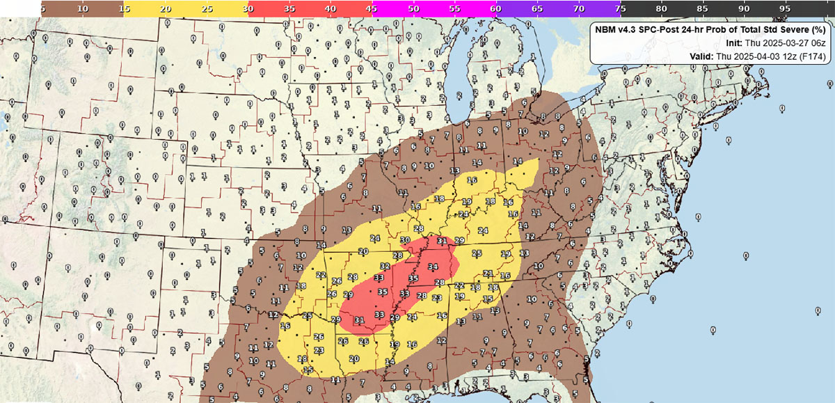
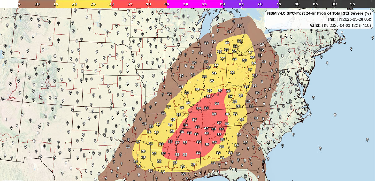
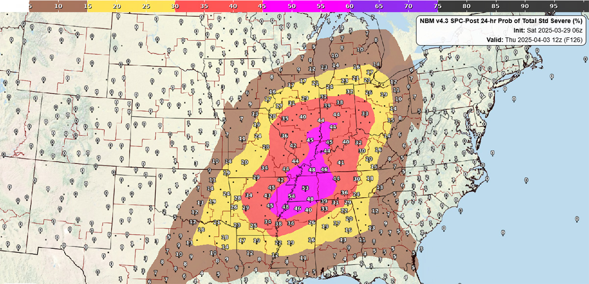
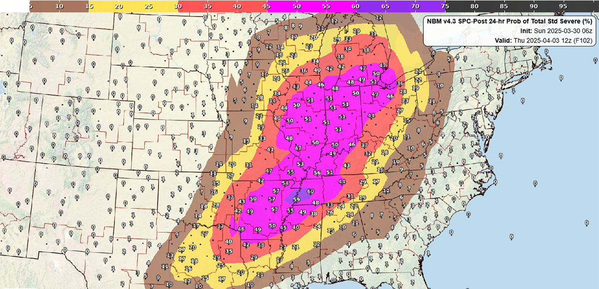
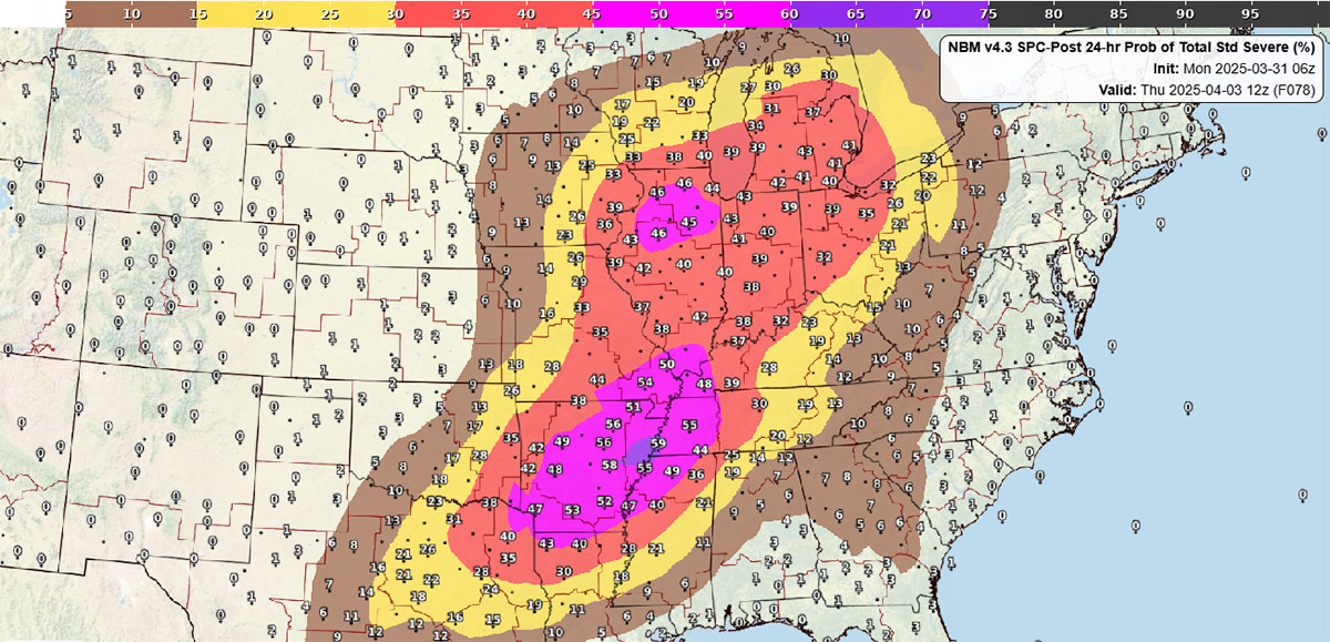
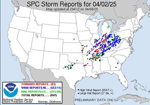
New SPC guidance for combined hazard severe weather probabilities issued for each day over the Days 3-8 period, available for the 06Z and 18Z cycles. A case example is shown in Figure 2 and SPC’s storm reports map for the relevant period can be found in Figure 3.
It is anticipated that these improvements and enhancements will benefit the NWS in its mission to support Impact-based Decision Support Services (IDSS) in both the deterministic and probabilistic space. For more information about NBMv4.3, please see the corresponding Service Change Notice [PDF].
The next major upgrade of the NBM, Version 5.0, will include new probabilistic products supporting fire weather and ocean wave forecasting, additional improvements to the suite of winter fields, precipitation products, an extension of hourly guidance from 36 to 48 hours, and much more.