NDFD Web Services - MDL
About NDFD - Digital Weather Markup Language (DWML)
MDL's involvement in Web Services dates back to 2005. MDL developed a WFS using the Digital Weather Markup Language (DWML). Today, this web services has 40 Million hits per day
National Digital Forecast Database (NDFD) Web Service
NOAA's National Weather Service offers several XML services
|Forecasts||Watch/warnings||Current Observations||Tropical Cyclone Advisories||Storm Prediction Center Forecast Products||Change Notices|
What is NDFD XML?
National Digital Forecast Database (NDFD) Extensible Markup Language (XML) is a service providing the public, government agencies, and commercial enterprises with data from the National Weather Service’s (NWS) digital forecast database. This service, which is defined in a Service Description Document, provides NWS customers and partners the ability to request NDFD data over the internet and receive the information back in an XML format. The request/response process is made possible by the NDFD XML Simple Object Access Protocol (SOAP) server. To see the details of the NDFD XML SOAP service, go to the following URL and click on the NDFDgen or NDFDgenByDay link:
https://graphical.weather.gov/xml/SOAP_server/ndfdXMLserver.php
If the web service description provided by the SOAP server does not meet your needs, similar information is available in the following Web Service Description Language (WSDL) document:
https://graphical.weather.gov/xml/DWMLgen/wsdl/ndfdXML.wsdl
In addition to the SOAP technology, this service exploits XML to enhance the ease with which NWS customers and partners can integrate NDFD data into their computer applications. XML is a W3C standard that allows its users to create languages with HTML-like tags and attributes. The NDFD XML language is called Digital Weather Markup Language (DWML) and its schema can be found at the following link:
https://graphical.weather.gov/xml/DWMLgen/schema/DWML.xsd
The schema defines the XML language’s vocabulary (available tags and attributes) and syntax (expected order of tags). Knowing how NDFD XML is constructed, users can write programs to process the XML document to get at the data it contains.
To see a sample Digital Weather Markup Language document that conforms to the DWML schema, click on any of the following links:
https://graphical.weather.gov/xml/DWMLgen/schema/latest_DWML.txt
https://graphical.weather.gov/xml/DWMLgen/schema/latest_DWML_glance.txt
https://graphical.weather.gov/xml/DWMLgen/schema/latest_DWMLByDay24hr.txt
https://graphical.weather.gov/xml/DWMLgen/schema/latest_DWMLByDay12hr.txt
Why provide an NDFD XML service?
The National Weather Service is striving to serve society’s needs for weather information by evolving its services from a text-based paradigm to one based on making NWS information available quickly, efficiently, and in convenient and understandable forms. The NDFD is one example of this transformation. NDFD XML takes yet another step towards a digital services era by making NDFD data available for computer to computer transfer and processing. NWS customers and partners can then enhance the value of NDFD data through the creation of value added products.
You can provide comments on this web service from the following page.
http://www.nws.noaa.gov/feedback.php
How often is NDFD XML updated?
The NDFD is updated no more than hourly. We request developers using this SOAP service for local applications only make a request for a specific point no more than once an hour. The database is currently updated by 45 minutes after the hour.
How is NDFD XML generated?
The first step to providing NDFD XML is the creation of the NDFD. For more information on how NDFD is created, visit the NDFD home page. With NDFD data available, a user application creates and sends a SOAP request to the NDFD XML SOAP server. The SOAP request is processed, creating the DWML document which is returned to the requesting application for processing. Figure 1 provides a graphical view of the process.
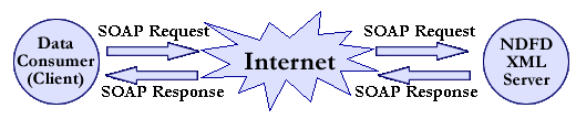
Figure 1. NDFD XML SOAP Process
You can download several simple sample client applications by clicking on the following links:
https://graphical.weather.gov/xml/sample_products/ndfdXML.tar
NOTE: These clients are examples only and will not run as is. To run the script, you will need to install a number of supporting software applications. You can review the readme file for additional information on using the sample clients.
What does NDFD XML contain?
NDFD XML contains forecasts for any combination of the following meteorological parameters:
http://www.nws.noaa.gov/ndfd/technical.htm#elements
For additional information on NDFD parameter definitions and available time projection, please see the NDFD technical page.
These NDFD parameters can be retrieved in their unsummarized form using the SOAP server functions NDFDgen() or NDFDgenZip(), or summarized over either 24- or 12-hourly periods using the functions NDFDgenByDay() or NDFDgenByDayZip. See the section below titled "How Do You Use the Web Service?" for more details on these two functions.
In addition to its meteorological content, NDFD XML contains meta data about the product. A description of the meta data as well as data XML tags and attributes can be found in the Digital Weather Markup Language Specification [PDF] [HTML] [DOC]
A list of all possible fields for icons and the weather conditions in summarized form can be found at NDFD Web Service's Icon/Weather Conditions XML fields.
How Do You Use the Web Service?
The first step to using the web service is to create a SOAP client. The client creates and sends the SOAP request to the server. The request sent by the client then invokes one of the server functions. There are currently nine functions: NDFDgen(), NDFDgenLatLonList(), LatLonListSubgrid(), LatLonListLine(), LatLonListZipCode(), LatLonListSquare(), CornerPoints(), NDFDgenByDay(), and NDFDgenByDayLatLonList(). See the tables below for required following user supplied input:
NDFDgen() function: Returns DWML encoded NDFD data for a point
| Input Name | Type | Example | Description |
| latitude | Decimal | 39.0000 | The WGS84 latitude of the point for which you want NDFD data. North latitude is positive. |
| longitude | Decimal | -77.0000 | The WGS84 longitude of the point for which you want NDFD data. West longitude is negative. |
| product | String | time-series | There are two products. The “time-series” product returns all data between the start and end times for the selected weather parameters. The “glance” product returns all data between the start and end times for the parameters maxt, mint, sky, wx, and icons |
| startTime | XML Date String | 2004-04-27T12:00 | The beginning time for which you want NDFD data. If the string is empty, the start time is assumed to be the earliest available time in the database. This input is only needed if one wants to shorten the time window data is to be retrieved for (less than entire 7 days worth), e.g. if user wants data for days 2-5. |
| endTime | XML Date String | 2004-04-30T12:00 | The ending time for which you want NDFD data. If the string is empty, the end time is assumed to be the last available time in the database. This input is only needed if one wants to shorten The time window data is to be retrieved for (less than entire 7 days worth), e.g. if user wants data for days 2-5. |
| Unit | String | e | The unit data is to be retrieved in. The default value is U.S. Standard, or English units ("e"). A value of "m" will return data in Metric, or SI units (The International System of Units). If the string is empty, data will be returned in U.S. Standard units, thus the input is only needed for metric conversion. |
| weatherParameters | Array of Booleans | maxt = TRUE | The NDFD parameters that you are requesting. For valid inputs see the NDFD Element Names Page. |
You can view an example of how to invoke NDFDgen() by selecting "NDFD Data For Single Point" on the following web page.
https://graphical.weather.gov/xml/SOAP_server/ndfdXML.htm
You can see a sample SOAP request for the NDFDgen() interface at https://graphical.weather.gov/xml/docs/SOAP_Requests/NDFDgen.xml
NDFDgenLatLonList() function: Returns DWML encoded NDFD data for a list of points
| Input Name | Type | Example | Description |
| listLatLon | string | 38.99,-77.02 39.70,-104.80 | List of WGS84 latitude and longitude pairs for the points for which you want NDFD data. Each point's latitude and longitude value is seperated by a comma. Each pair (one latitude and longitude value) is separated by a space. Number of points requested can not exceed 200. |
| product | String | time-series | There are two products. The “time-series” product returns all data between the start and end times for the selected weather parameters. The “glance” product returns all data between the start and end times for the parameters maxt, mint, sky, wx, and icons |
| startTime | XML Date String | 2004-04-27T12:00 | The beginning time for which you want NDFD data. If the string is empty, the start time is assumed to be the earliest available time in the database. This input is only needed if one wants to shorten the time window data is to be retrieved for (less than entire 7 days worth), e.g. if user wants data for days 2-5. |
| endTime | XML Date String | 2004-04-30T12:00 | The ending time for which you want NDFD data. If the string is empty, the end time is assumed to be the last available time in the database. This input is only needed if one wants to shorten the time window data is to be retrieved for (less than entire 7 days worth), e.g. if user wants data for days 2-5. |
| Unit | String | e | The unit data is to be retrieved in. The default value is U.S. Standard, or English units ("e"). A value of "m" will return data in Metric, or SI units (The International System of Units). If the string is empty, data will be returned in U.S. Standard units, thus the input is only needed for metric conversion. |
| weatherParameters | Array of Booleans | maxt = TRUE | The NDFD parameters that you are requesting. For valid inputs see the NDFD Element Names Page. |
You can view an example of how to invoke NDFDgenLatLonList() by selecting "NDFD Data For Multiple Points" on the following web page. NOTE: Number of points requested can not exceed 200.
https://graphical.weather.gov/xml/SOAP_server/ndfdXML.htm
You can see a sample SOAP request for the NDFDgenLatLonList() interface at https://graphical.weather.gov/xml/docs/SOAP_Requests/NDFDgenLatLonList.xml
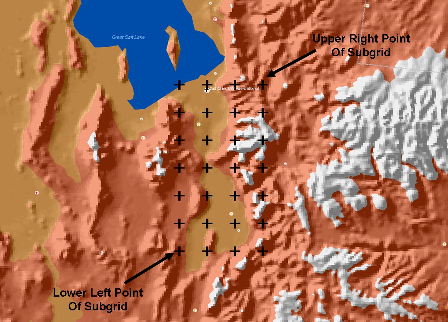
LatLonListSubgrid() function:
Returns the WGS84 latitude and longitude values of all the NDFD grid points within a rectangular subgrid as defined by points at the lower left and upper right corners of the rectangle. The returned list of points is suitable for input into NDFDgenLatLonList(), NDFDgenByDayLatLonList(), and GmlLatLonList() which will return NDFD data for those points. NOTE: The subgrid locations will only form a rectangle when viewed in the NDFD projection applicable to the grid.
| Input Name | Type | Example | Description |
| lowerLeftLatitude | Decimal | 33.8835 | The WGS84 latitude of the lower left point of the rectangular subgrid for which you want NDFD grid points. North latitude is positive. |
| lowerLeftLongitude | Decimal | -80.0679 | The WGS84 longitude of the lower left point of the rectangular subgrid for which you want NDFD grid points. West longitude is negative. |
| upperRightLatitude | Decimal | 33.8835 | The WGS84 latitude of the upper right point of the rectangular subgrid for which you want NDFD grid points. North latitude is positive. |
| upperRightLongitude | Decimal | -80.0679 | The WGS84 longitude of the upper right point of the rectangular subgrid for which you want NDFD grid points. West longitude is negative. |
| resolution | Decimal | 20.0 | The default resolution for NDFD data is typically 5km. However, users can request latitude and longitude values for resolutions greater ( 10km, 15km, 20km, etc.) than the native resolution so as to reduce the number of points returned. |
You can view an example of how to invoke LatLonListSubgrid() by selecting "Grid Points For Subgrid" on the following web page.
https://graphical.weather.gov/xml/SOAP_server/ndfdXML.htm
You can see a sample SOAP request for the LatLonListSubgrid() interface at https://graphical.weather.gov/xml/docs/SOAP_Requests/LatLonListSubgrid.xml
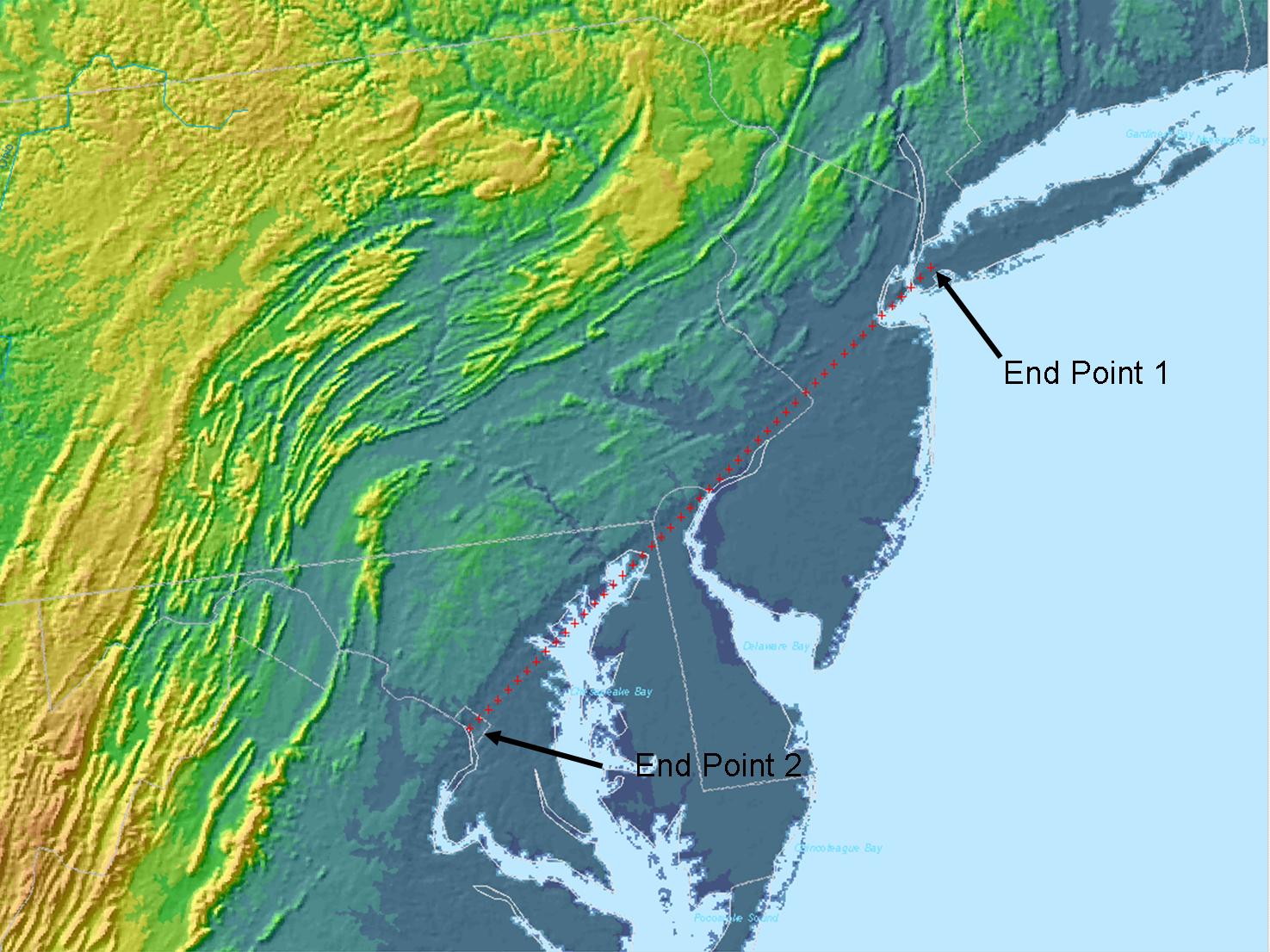
LatLonListLine() function:
Returns the WGS84 latitude and longitude values for all points on a line defined by the line's end points. The returned list of points is suitable for input into NDFDgenLatLonList(), NDFDgenByDayLatLonList(), and GmlLatLonList() which will return NDFD data for those points. NOTE: The list of locations will only form a straight line when viewed in the NDFD projection applicable to the grid.
| Input Name | Type | Example | Description |
| endPoint1Lat | Decimal | 39.0000 | The WGS84 latitude of the first end point of the line for which you want NDFD grid points. North latitude is positive. |
| endPoint1Lon | Decimal | -77.0000 | The WGS84 longitude of the first end point of the line for which you want NDFD grid points. West longitude is negative. |
| endPoint2Lat | Decimal | 39.0000 | The WGS84 latitude of the second end point of the line for which you want NDFD grid points. North latitude is positive. |
| endPoint2Lon | Decimal | -77.0000 | The WGS84 longitude of the second end point of the line for which you want NDFD grid points. West longitude is negative. |
You can view an example of how to invoke LatLonListLine() by selecting "Grid Points For A Line" on the following web page.
https://graphical.weather.gov/xml/SOAP_server/ndfdXML.htm
You can see a sample SOAP request for the LatLonListLine() interface at https://graphical.weather.gov/xml/docs/SOAP_Requests/LatLonListLine.xml
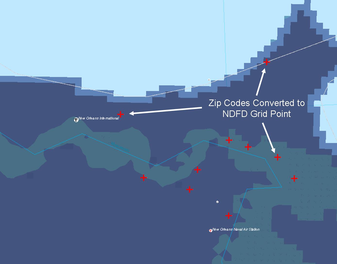
LatLonListZipCode() function:
Returns the WGS84 latitude and longitude values for one or more zip codes (50 United States and Puerto Rico). The returned list of points is suitable for input into NDFDgenLatLonList(), NDFDgenByDayLatLonList(), and GmlLatLonList() which will return NDFD data for those points.
| Input Name | Type | Example | Description |
| zipCodeList | String | 20910 | The zip code of the area for which you want NDFD grid points. |
You can view an example of how to invoke LatLonListZipCode() by selecting "Grid Points For A Zip Code" on the following web page.
https://graphical.weather.gov/xml/SOAP_server/ndfdXML.htm
You can see a sample SOAP request for the LatLonListZipCode() interface at https://graphical.weather.gov/xml/docs/SOAP_Requests/LatLonListZipCode.xml
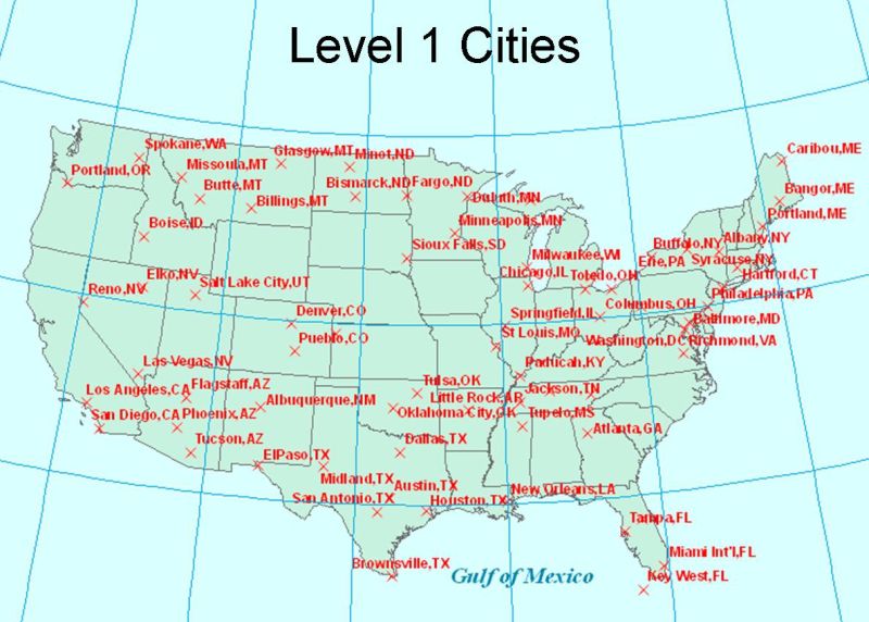
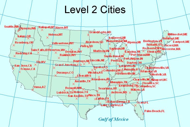
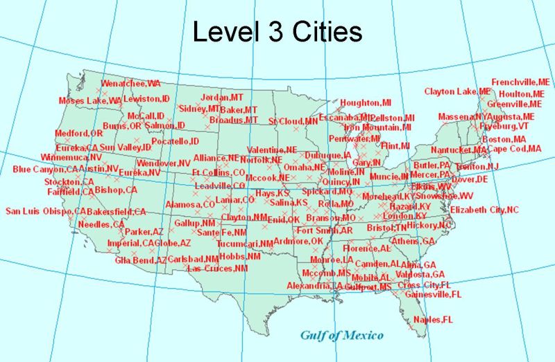
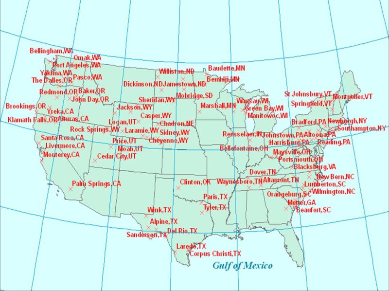
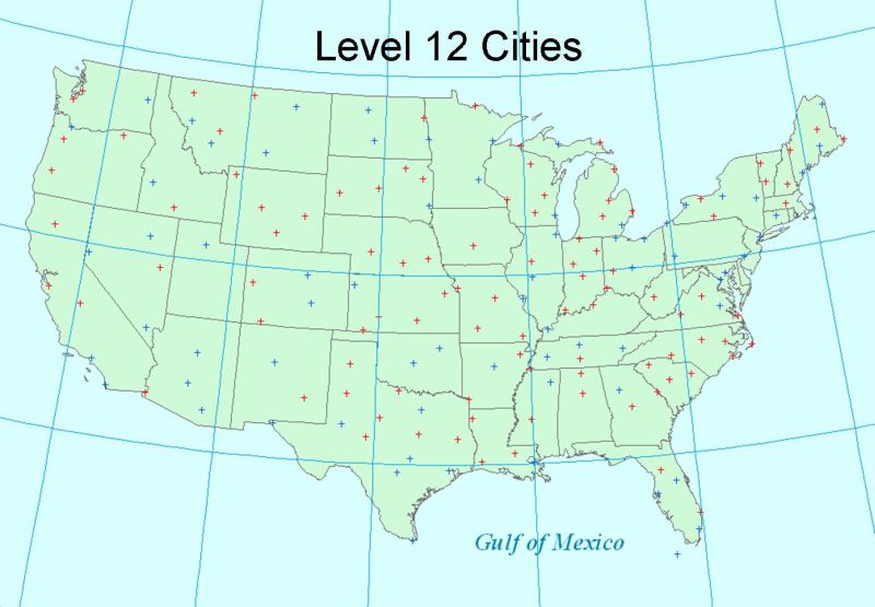
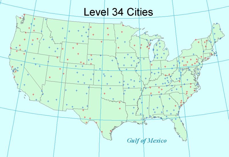
LatLonListCityNames() function:
Returns the WGS84 latitude and longitude values for a predefined list of cities. The cities are grouped into a number of subsets to facilitate requesting data. You can view the cities in each group by clicking on the links in the table below. The returned list of pointsis suitable for input into NDFDgenLatLonList(), NDFDgenByDayLatLonList(), and GmlLatLonList() which will return NDFD data for those points.
| Input Name | Type | Example | Description |
| displayLevel | Integer | 12 | 1 = Primary Cities. 2 = Secondary Cities. 3 = Cities that increase data density across the US (cities 1 - 200). 4 = Cities that increase data density across the US (cities 201 - 304). 12 = Combines cities in 1 and 2 above. 34 = Combines cities in 3 and 4 above. 1234 = Combines cities in 1, 2, 3, and 4 above. |
You can view an example of how to invoke LatLonListCityNames() by selecting "Grid Points For NDFD Cities" on the following web page.
https://graphical.weather.gov/xml/SOAP_server/ndfdXML.htm
You can see a sample SOAP request for the LatLonListCityNames() interface at https://graphical.weather.gov/xml/docs/SOAP_Requests/LatLonListCityNames.xml
LatLonListSquare() function:
Returns the WGS84 latitude and longitude values for a rectangle defined by a center point and distances in the latitudinal and longitudinal directions. The returned list of points is suitable for input into NDFDgenLatLonList(), NDFDgenByDayLatLonList(), and GmlLatLonList() which will return NDFD data for those points. NOTE: The subgrid locations will only form a rectangle when viewed in the NDFD projection applicable to the grid.
| Input Name | Type | Example | Description |
| centerPointLat | Decimal | 39.0000 | The WGS84 latitude of the center or the rectangle for which you want NDFD grid points. North latitude is positive. |
| centerPointLon | Decimal | -77.0000 | The WGS84 longitude of the center or the rectangle for which you want NDFD grid points. West longitude is negative. |
| distanceLat | Decimal | 50.0 | The distance from the center point in the latitudinal direction to the rectangle's East/West oriented sides. |
| distanceLon | Decimal | 50.0 | The distance from the center point in the longitudinal direction to the rectangle's North/South oriented side. |
| resolution | Decimal | 20.0 | The default resolution for NDFD data is typically 5km. However, users can request latitude and longitude values for resolutions greater ( 10km, 15km, 20km, etc.) than the native resolution so as to reduce the number of points returned. |
You can view an example of how to invoke LatLonListSquare() by selecting "Grid Points For Subgrid (Central Point)" on the following web page.
https://graphical.weather.gov/xml/SOAP_server/ndfdXML.htm
You can see a sample SOAP request for the LatLonListSquare() interface at https://graphical.weather.gov/xml/docs/SOAP_Requests/LatLonListSquare.xml
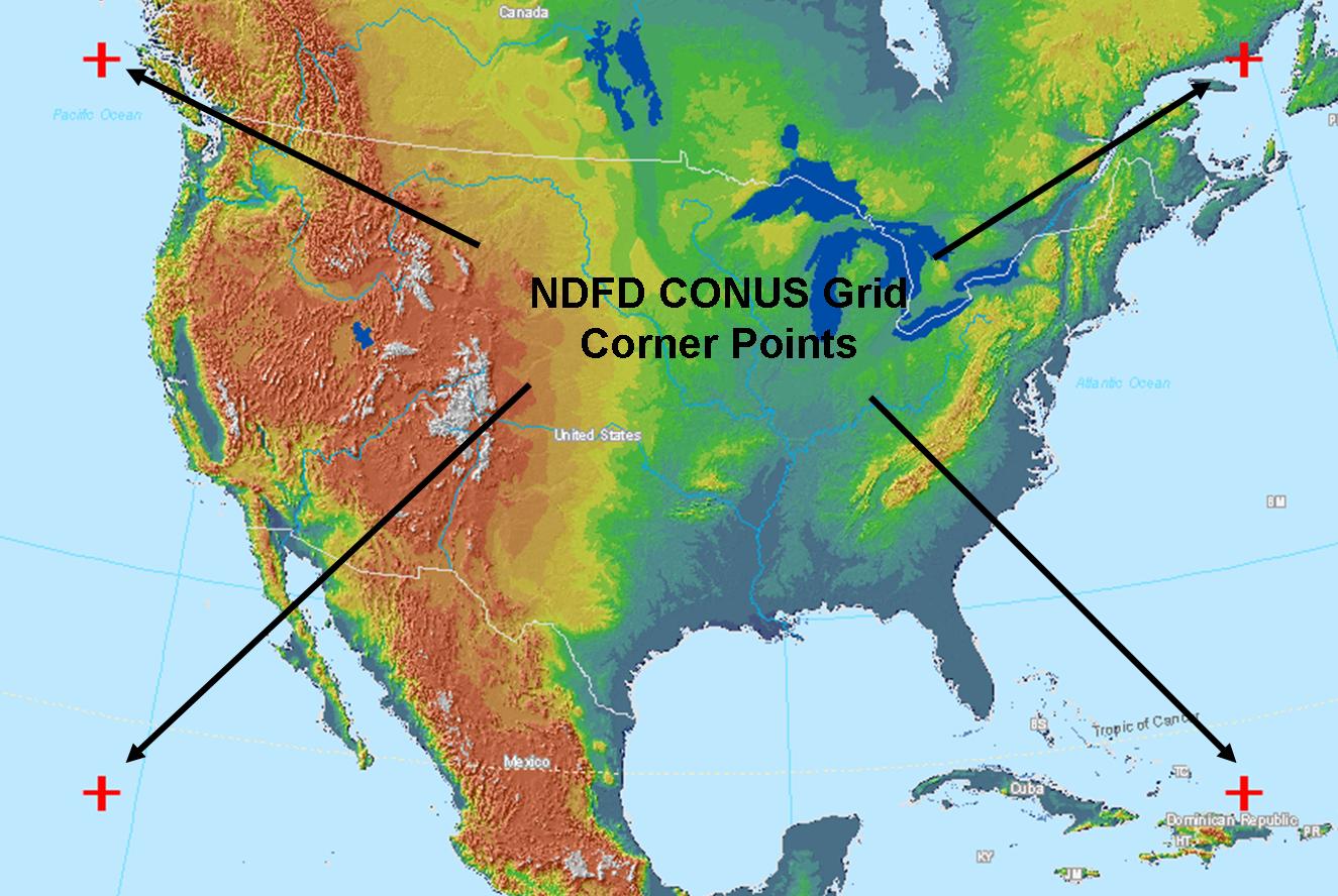
CornerPoints() function:
Returns the WGS84 latitude and longitude values for the corners of an NDFD grid as well as the resolution required to retrieve the entire grid and still stay under the maximum allowed point restriction.
| Input Name | Type | Example | Description |
| sector | String | conus | One of the NDFD grids (conus, alaska, nhemi, guam, hawaii, and puertori). |
You can view an example of how to invoke CornerPoints() by selecting "Corner Grid Points" on the following web page.
https://graphical.weather.gov/xml/SOAP_server/ndfdXML.htm
You can see a sample SOAP request for the CornerPoints() interface at https://graphical.weather.gov/xml/docs/SOAP_Requests/CornerPoints.xml
GmlLatLonList() function:
Returns Digital Weather GML encoded NDFD data for a list of points a single valid time.
| Input Name | Type | Example | Description |
| listLatLon | string | 38.99,-77.02 39.70,-104.80 | List of WGS84 latitude and longitude pairs for the points for which you want NDFD data. Each point's latitude and longitude value is seperated by a comma. Each pair (one latitude and longitude value) is separated by a space. Number of points requested can not exceed 200. |
| requestedTime | XML Date String | 2004-04-27T12:00:00 | The time for which you want NDFD data. |
| featureType | string | Forecast_Gml2Point | GML 2 Compliant Data Structure: Forecast_Gml2Point GML 3 Compliant Data Structures: Forecast_GmlsfPoint, Forecast_GmlObs, NdfdMultiPointCoverage KML 2 Compliant Data Structure: Ndfd_KmlPoint |
| weatherParameters | Array of Booleans | maxt = TRUE | The NDFD parameters that you are requesting. For valid inputs see the NDFD Element Names Page. |
You can view an example of how to invoke GmlLatLonList() by selecting "NDFD Data Encoded in GML for Single Time" on the following web page. NOTE: Number of points requested can not exceed 200.
https://graphical.weather.gov/xml/SOAP_server/ndfdXML.htm
You can see a sample SOAP request for the GmlLatLonList() interface at https://graphical.weather.gov/xml/docs/SOAP_Requests/GmlLatLonList.xml
GML is an Open Geospatial Consortium standard for encoding geospatial data. One of the advantages of NDFD GML is that it is a recognized standard. As a result, GML and application schema derived from it are supported by a number of GIS applications. There are examples of importing GML-encoded NDFD data into several applications at the following link.
Tutorials showing how to use various compatible clients
Tutorials on integrating the NDFD Web Service and clients like ArcGIS, Google Earth, and Google Maps.
In addition to GML, the GmlLatLonList() service function can return Keyhole Markup Language (KML) encoded NDFD data. KML can be viewed with freely available tools like Google Earth.
GmlTimeSeries() function:
Returns Digital Weather GML encoded NDFD data for a list of points during a user specified time period.
| Input Name | Type | Example | Description |
| listLatLon | string | 38.99,-77.02 39.70,-104.80 | List of WGS84 latitude and longitude pairs for the points for which you want NDFD data. Each point's latitude and longitude value is seperated by a comma. Each pair (one latitude and longitude value) is separated by a space. Number of points requested can not exceed 200. |
| startTime | XML Date String | 2008-01-01T00:00:00 | The start time for which you want NDFD data. |
| endTime | XML Date String | 2010-12-31T23:59:59 | The end time for which you want NDFD data. |
| compType | string | Between | Comparison type. Can be IsEqual, Between, GreatThan, GreaterThanOrEqual, LessThan, or LessThanOrEqual. |
| featureType | string | Forecast_Gml2Point | GML 2 Compliant Data Structure: Forecast_Gml2Point GML 3 Compliant Data Structures: Forecast_GmlsfPoint, Forecast_GmlObs, NdfdMultiPointCoverage KML 2 Compliant Data Structure: Ndfd_KmlPoint |
| propertyName | comma delimited list | maxt,mint,wx | The NDFD element that you are requesting. For valid inputs see the NDFD Element Names Page. |
You can view an example of how to invoke GmlTimeSeries() by selecting "NDFD Data Encoded in GML for Time Period" on the following web page. NOTE: Number of points requested can not exceed 200.
https://graphical.weather.gov/xml/SOAP_server/ndfdXML.htm
You can see a sample SOAP request for the GmlLatLonList() interface at https://graphical.weather.gov/xml/docs/SOAP_Requests/GmlTimeSeries.xml
GML is an Open Geospatial Consortium standard for encoding geospatial data. One of the advantages of NDFD GML is that it is a recognized standard. As a result, GML and application schema derived from it are supported by a number of GIS applications. There are examples of importing GML-encoded NDFD data into several applications at the following link.
NDFDgenByDay() function:
Returns DWML encoded NDFD data for a point. Data for each point is summarized for either a 24- or 12-hour time period
| Input Name | Type | Example | Description |
| latitude | Decimal | 39.0000 | The WGS84 latitude of the point for which you want NDFD data. North latitude is positive. |
| longitude | Decimal | -77.0000 | The WGS84 longitude of the point for which you want NDFD data. West longitude is negative. |
| startDate | XML Date String | 2004-04-27 | The beginning day for which you want NDFD data. If the string is empty, the start date is assumed to be the earliest available day in the database. This input is only needed if one wants to shorten the time window data is to be retrieved for (less than entire 7 days worth), e.g. if user wants data for days 2-5. |
| numDays | Integer | 7 | The number of days worth of NDFD data you want. Default will be all available data in the database. This input is only needed if one wants to shorten the time window data is to be retrieved for (less than entire 7 days worth), e.g. if user wants data for days 2-5. |
| Unit | String | e | The unit data is to be retrieved in. The default value is U.S. Standard, or English units ("e"). A value of "m" will return data in Metric, or SI units (The International System of Units). If the string is empty, data will be returned in U.S. standard units, thus the input is only needed for metric conversion. |
| format | String | 12 hourly | There are two formats. The “24 hourly” format returns NDFD data summarized for a 24 hour period running from 6:00 AM to 6:00 AM. The “12 hourly” format summarizes NDFD data into two 12 hour periods per day that run from 6:00 AM to 6:00 PM and 6:00 PM to 6:00 AM |
You can view an example of how to invoke NDFDgenByDay() by selecting "NDFD Data For Single Point" on the following web page.
https://graphical.weather.gov/xml/SOAP_server/ndfdSOAPByDay.htm
You can see a sample SOAP request for the NDFDgenByDay() interface at https://graphical.weather.gov/xml/docs/SOAP_Requests/NDFDgenByDay.xml
NDFDgenByDayLatLonList() function:
Returns DWML encoded NDFD data for a list of points. Data for each point is summarized for either a 24- or 12-hour time period
| Input Name | Type | Example | Description |
| listLatLon | Decimal | 38.99,-77.02 39.70,-104.80 | List of WGS84 latitude and longitude pairs for the points for which you want NDFD data. Each point's latitude and longitude value is seperated by a comma. Each pair (one latitude and longitude value) is separated by a space. Number of points requested can not exceed 200. |
| startDate | XML Date String | 2004-04-27 | The beginning day for which you want NDFD data. If the string is empty, the start date is assumed to be the earliest available day in the database. |
| numDays | Integer | 7 | The number of days worth of NDFD data you want. |
| Unit | String | e | The unit data is to be retrieved in. The default value is U.S. Standard, or English units ("e"). A value of "m" will return data in Metric, or SI units (The International System of Units). If the string is empty, data will be returned in U.S. standard units, thus the input is only needed for metric conversion. |
| format | String | 12 hourly | There are two formats. The “24 hourly” format returns NDFD data summarized for a 24 hour period running from 6:00 AM to 6:00 AM. The “12 hourly” format summarizes NDFD data into two 12 hour periods per day that run from 6:00 AM to 6:00 PM and 6:00 PM to 6:00 AM |
You can view an example of how to invoke NDFDgenByDayLatLonList() by selecting "NDFD Data For Multiple Points" on the following web page. NOTE: Number of points requested can not exceed 200.
https://graphical.weather.gov/xml/SOAP_server/ndfdSOAPByDay.htm
You can see a sample SOAP request for the NDFDgenByDayLatLonList() interface at https://graphical.weather.gov/xml/docs/SOAP_Requests/NDFDgenByDayLatLonList.xml
Once the SOAP server returns the XML document back to the client, you can then parse the DWML using SAX, the DOM, or XSLT.
All latitude and longitude values provided as input or in the output DWML are based on the World Geodetic System 1984 (WGS84). For more inforation on the NDFD spatial reference system see the NDFD Spatial Reference System page.
What if I need lots of NDFD data or find the web service too slow?
You should consult the NDFD web services use guidelines.
The NWS has developed a program called degrib that can output NDFD data encoded in DWML. Degrib is a C program that allows you to visualize NDFD GRIB2 data and convert these binary files into other formats. If you are a web service user who wants DWML-encoded data for a large number of NDFD points, degrib will allow you to move the DWML-encoding process to your computer. By using degrib to process the NDFD data on a local computer, you may be able to significantly improve the speed with which your program is able to ingest NDFD data. The NWS makes a degrib executable available for Microsoft Windows PCs and the degrib source code available for compilation on other computer operating systems. To download degrib software, visit the URL http://www.nws.noaa.gov/mdl/degrib/register.php. Once you have the degrib software running, you will need to maintain updated NDFD GRIB2 files. For more information on downloading NDFD GRIB2 files from the NWS Telecommunication Operations Center, see Data Locations Page. For additional help on using degrib to convert NDFD GRIB2 files into DWML see the degrib tutorial and man page.
What if I prefer not to use SOAP to access NDFD web services?
Please visit the following web page:
NWS XML Services Change Notices 
Below are listed recent change notices for NWS XML services. A complete listing is available. An RSS feed of the change notices is also available. These notices are used to announce major changes, schema changes and new services.
NDFD-XML: Updated the degrib executable and ndfdXMLserver.php and the wsdl: ndfdXML.wsdl, for NDFD Web Service to address missing elements (maxrh, minrh, iceaccum, 6 Tropical wind threshold probabilities).
Mar 13, 2014 at 11AM Easter Time. A new deployment of the NDFD REST And SOAP Web Service will be implemented to address Maximum Relative Humidity, Minimum Relative Humidity, and Ice Accumulation not dissiminating via the Web Service. They have been added to the weatherParameters array in ndfdXMLserver.php file. Also, 2 defunct elements, the tstmprb and tstmcat, were removed from the ndfdXML.wsdl file. Also, there was a long standing issue with the 6 Tropical Wind Threshold Probability elements (incw34, incw50, incw64, cumw34, cumw50, cumw64) causing Seg Faults depending on list of point's in query, or a doubling up of the data.
NDFD-XML: New NDFD SOAP/REST XML Web Service Install Tuesday June 19th, 2012
On Tuesday, June 19th, MDL will install a new version of the NDFD SOAP/REST XML Web Service. The release is for the addition of two new NDFD elements: Maximum and Minimum Daily Relative Humidity. This should not interrupt services, except for those who have scripts in which every parameter must be denoted: i.e., for a new SOAP Request, the following will need to be added: ------------------------------------------------------------------------------------------------------------------------- maxrh xsi:type="xsd:boolean">0 /maxrh> ------ minrh xsi:type="xsd:boolean">0 /minrh> -------------------------------------------------------------------------------------------------------------------------------- On Mon June 18th or Tuesday June 19th, as the time of the switchover becomes clear, we will send out another email, we will post the information on the NDFD Web Service yahoo list forum at https://tech.groups.yahoo.com/group/NDFD_SOAP_Service/ and post the information here in xml_changes.xml (https://graphical.weather.gov/xml/xml_changes.xml and https://graphical.weather.gov/xml/xml_change_notices.php) Please use the following channels to let us know of any problems accessing the NDFD Web Service immediately after the switch: 1) Email the NIDS support crew at nids.support@noaa.gov ----------------------------------------------- 2) Open up a trouble ticket with the National Weather Service Telecommunication Gateway's TOC (Traffic Operations Center) at toc.nwstg@noaa.gov ------------------------------------------------- 3) Use the NDFD Web Service yahoo list forum to report issues: https://tech.groups.yahoo.com/group/NDFD_SOAP_Service/
NDFD-XML: Maximum and Minimum Relative Humidity added to NDFD Web Service
Two new Fire Weather elements, Maximum and Minimum Relative Humidity, will be added for dissimination through the NDFD Web Service. For more information see the Technical Implementation Notice (TIN). The name of the elements are "maxrh" and "minrh", seen here in the WSDL (https://graphical.weather.gov/xml/SOAP_server/ndfdXMLserver.php?wsdl).