SLOSH - MDL
SLOSH
MODEL AVAILABILITY
SLOSH is available via a private GitHub repository. Please email arthur.taylor@noaa.gov so he can invite you to the repository. He will need (a) concurrence with the SLOSH License, and (b) a GitHub user account to add for Read-Access. Please note that the repository contains the SLOSH model code but lacks the hypothetical inputs and results utilized by NHC to generate MEOWs and MOMs for FEMA's risk analysis. To access that data, you would need to contact either FEMA or NHC directly.
ABOUT
The Sea Lake and Overland Surges from Hurricanes (SLOSH) model (Jelesnianski, et al) is a numerical model that computes storm surge using a set of finite-difference equations to solve the Navier-Stokes equations of motion. The differential equations are applied to a grid mesh covering the forecast area... some non-linear terms in the equations of motion, ... finite amplitude effects but not advective terms in the equations of motion
Wind: It relies on a set of "driving" forces to represent the surface of wind stress and a pressure gradient body force. These driving forces are attained by providing a wind model (Jelesnianski and Taylor, 1973) with the storm's location, central pressure, size, and forward speed. Thus SLOSH is considered a "diagnostic" model, as it doesn't forecast a storm's evolution, but rather diagnoses how the water reacts.
Basin: SLOSH's grid mesh is based on a locally orthogonal polar, elliptical or hyperbolic Arakawa-B grid with momentum points on the corners and water heights at the center. This allows for higher resolution in areas of interest and enables larger time-steps to satisfy the differential equation's CFL stability condition. Barriers (e.g. roads and levees) are simulated by adjusting the momentum points. Sub-grid scale features (e.g. channels, barriers and flow of surge up rivers) are modeled via simple hydraulic procedures. Inundation is permitted by simply turning grid cells on and off as waters inundate or recede.
- Vertical Datum: Currently the North American Vertical Datum of 1988 (NAVD-88) is used for CONUS basins, while 'Island-Datum' is used for Puerto Rico, the U.S. Virgin Islands, and Hawaii basins. Historically, SLOSH had used National Geodetic Vertical Datum of 1929 (NGVD-29), but those basins have been retired.
- Horizontal Datum: SLOSH uses an Earth with a semi-major axis A of 6,378,294 m and an eccentricity E of 0.082 437 112 686 627. That implies a semi-minor axis B = A * sqrt (1 - E^2) = 6,356,584 m, and an inverse flattening C = A/(A-B) = 293.7952. This corresponds closely to the Clarke 1880 ellipsoid, except for an accidental juxtaposition of the the tens and ones place in A. More recently, SLOSH has been moving to the Geodetic Reference System of 1980 (GRS-80) ellipsoid with an A of 6,378,137 m and an eccentricity of 0.081 819 191 042 815 8. Note WGS84 has the same A, but its eccentricity is 0.081 819 190 842 621 5.
Geographic Coverage: Active Tropical Basins (fine resolution; narrow scope) as of 9/13/2018: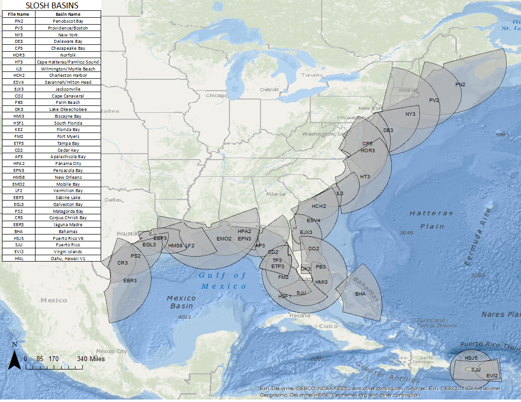
Tides: ...(something about tides)... It is difficult to phase storm landfall and astronomical tide. A small error in time on track positions will invalidate computations with astronomical tide.
Waves: Wave run-up ignored... Wave set-up ignored... exotic effects occur such as an increase of density from suspended sand particles
River / Rain: River flow upstream could be incorporated as a boundary condition and rain as a "source", if amenable to quantification with a forecasted storm
Time-history bottom stress corrected for finite amplitude effects...
Performance
... Statistics on performance ...
... Strengths and limitations ...
FAQ
- How do I get the model?
- How do I generate input files?
- How do I modify a basin?
- How do I run the model?
- How do I display the results?
OFFICIAL FORECASTS
STORM SURGE GUIDANCE
- P-Surge CONUS | Puerto Rico
- P-ETSS
- ET-Surge New (2.0) | Original (1.0)
- STOFS
WATER OBSERVATIONS
WIND GUIDANCE
HURRICANE TRACKS
CONTACT
-
For more information about MDL's Storm Surge, please contact: Arthur.Taylor@noaa.gov