LAMP Card 2.2.0 - MDL
Description of the GFS LAMP Alphanumeric Message
The GFS MOS-Based LAMP guidance is generated using the current station observations for the cycle time, analyses of the observations, simple model output, and the MOS data derived from NCEP's Global Spectral Model. To stay updated about the availability of GFS-LAMP guidance for the different cycle times, please refer to our Changes Document. This guidance is valid for stations in the United States, Puerto Rico, and the U.S. Virgin Islands. Please refer to the following document for the most recent station list. Forecast elements are valid from 1 to 25 hours in advance.
The information that follows applies to the LAMP v2.2.0 Alphanumeric Text Messages, which are valid October 2019.
Forecast elements are valid from 1 to 25 hours in advance, except from 1 to 38 hours for CIG, VIS, and OBV.
- With LMP v2.2.0 and beyond, there are 3 types of ASCII text bulletins. They are:
- The standard bulletin which covers the 1-25 hour period.
- The extended bulletin which covers the 26-38 hour period.
- The full bulletin which covers the 1-38 hour period. This bulletin is currently only available via the LAMP website.
The below example shows the full bulletin, but the key applies to all the bulletins.
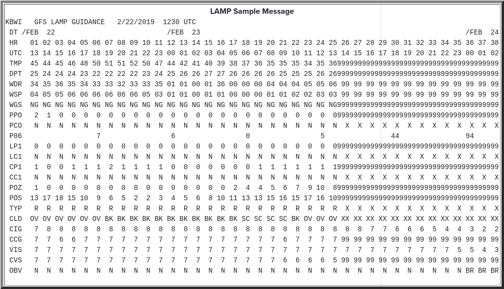
- UTC Hour of the day in UTC time. This is the hour at which the forecast is valid, or if the forecast is valid for a period, the end of the forecast period.
- TMP surface temperature valid at that hour.
- DPT surface dewpoint valid at that hour.
- WDR forecasts of the 10-meter wind direction at the hour, given in tens of degrees.
- WSP forecasts of the 10-meter wind speed at the hour, given in knots.
- WGS forecasts of the 10-meter wind gust at the hour, given in knots. "NG" means that no gust is forecast.
- PPO probability of precipitation occurring on the hour. The precipitation need not be measurable.
- PCO categorical forecast of yes (Y) or no (N) indicating if precipitation, not necessarily measurable, will occur on the hour.
- P06 probability of measurable precipitation (PoP) during a 6-h period ending at that time.
- LP1 probability of lightning (at least one total lightning flash) occurring during the 1-hr period ending at the indicated time.
- LC1 categorical forecast of no (N), low (L), medium (M), or high (H) potential for lightning (at least one total lightning flash) occurring during the 1-hr period ending at the indicated time.
- CP1 probability of convection (at least one total lightning flash and/or radar reflectivity of 40dBZ or higher) occurring during the 1-hr period ending at the indicated time.
- CC1 categorical forecast of no (N), low (L), medium (M), or high (H) potential for convection (at least one total lightning flash and/or radar reflectivity of 40dBZ or higher) occurring during the 1-hr period ending at the indicated time.
- POZ* conditional probability of freezing pcp occurring at the hour. This probability is conditional on precipitation occurring.
- POS* conditional probability of snow occurring at the hour. This probability is conditional on precipitation occurring.
- TYP* conditional precipitation type at the hour. This category forecast is conditional on precipitation occurring.
- CLD forecast categories of total sky cover valid at that hour.
- CIG ceiling height categorical forecasts at the hour.
- CCG conditional ceiling height categorical forecasts at the hour. This category forecast is conditional on precipitation occurring.
- VIS visibility categorical forecasts at the hour.
- CVS conditional visibility categorical forecasts at the hour. This category forecast is conditional on precipitation occurring.
- OBV obstruction to vision categorical forecasts at the hour.
*In the contiguous United States, these products are available September 1 - May 31.
Definitions of Categorical Elements
|
|
||||||||||||||||||||||||||||||||||||||||||||||||||||||||||||||||||||||