Weather Grid FAQ - MDL
Q: What is "Predominant Weather"?
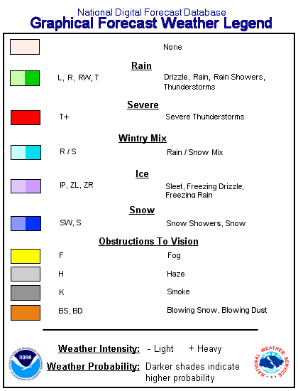
A: Predominant Weather (Wx) is the expected weather (precipitating or non-precipitating) valid at the indicated hour. The weather element includes type, probability, and intensity information.
Q: What images are available?
A: Current images and example images are both available.
2.5 km CONUS
- 2.5 km CONUS GMOS Weather* displays current GMOS Predominant Weather; Precipitation Potential Index; Freezing, Frozen, and Liquid Precipitation Indices; Thunder Potential Index; and Severe Potential Index for 2.5 km CONUS.
- CONUS GMOS/NDFD Comparison* displays current Predominant Weather, Precipitation Potential Index and precipitaiton type category forecasts from GMOS and NDFD for CONUS.
- 2.5 km CONUS GMOS Weather Evaluation* displays all GMOS Predominant Weather forecasts for yesterday with observed weather overlaid for evaluation.
Alaska
- Alaska GMOS Weather* displays current GMOS Predominant Weather; Precipitation Potential Index; Freezing, Frozen, and Liquid Precipitation Indices; Thunder Potential Index; and Severe Potential Index for Alaska.
- Alaska GMOS/NDFD Comparison* displays current Predominant Weather, Precipitation Potential Index and precipitaiton type category forecasts from GMOS and NDFD for Alaska.
- Alaska GMOS Weather Evaluation* displays all GMOS Predominant Weather forecasts for yesterday with observed weather overlaid for evaluation.
Sample Cases
- 2.5 km CONUS Weather Example* displays GMOS Predominant Weather, Precipitation Potential Index, Freezing, Frozen, and Liquid Precipitation Indices; Thunder Potential Index; Severe Potential Index; Precipitation Intensity; and NDFD Predominant Weather and PPI. The GMOS elements are from the April 2, 2011 12Z forecast cycle. The NDFD forecast is from the April 2, 2011 18Z forecast cycle.
- GMOS/HRMOS Comparison* displays GMOS Predominant Weather obtained from GMOS probabilities of precipitation and GMOS Predominant Weather obtained from HRMOS probabilities of precipitation.
- Alaska Weather Example* displays GMOS Predominant Weather, Precipitation Potential Index, Freezing, Frozen, and Liquid Precipitation Indices; Thunder Potential Index; Severe Potential Index; and NDFD Predominant Weather and PPI. The GMOS elements are from the May 9, 2012 00Z forecast cycle. The NDFD forecast is also from the May 9, 2012 00Z forecast cycle.
To view other 2.5 km GMOS elements, use the "Element-Specific Images" links on the Gridded Model Output Statistics (MOS) Experimental 2.5km Grids* site.
Q: What GMOS elements are used to make weather?
A:
| GMOS Element | Wx Component | 2.5 km CONUS Availability | Alaska Availability |
|---|---|---|---|
|
3-hour Probability of Precipitation Occurrence (PoPO3) |
Precipitation probability |
All year |
All year |
|
6-hour Probability of Precipitation (PoP6) |
Precipitation probability |
All year |
All year |
|
12-hour Probability of Precipitation (PoP12) |
Precipitation probability |
All year |
All year |
|
Temperature |
Precipitation type |
All year |
All year |
|
Dewpoint |
Precipitation type |
All year |
All year |
|
Conditional Probability of Freezing Preciptiation |
Precipitation type |
September 1 - May 31 |
September 1 - June 15 |
|
Conditional Probability of Frozen Preciptiation |
Precipitation type |
September 1 - May 31 |
September 1 - June 15 |
|
Conditional Probability of Liquid Precipitation |
Precipitation type |
September 1 - May 31 |
September 1 - June 15 |
|
6-hour Quantitative Precipitation Forecast (QPF6) |
Precipitation intensity |
All year |
All year |
|
3-hour Probability of Thunderstorm |
Thunder probability |
All year |
May 1 - September 30 |
|
6-hour Probability of Thunderstorm |
Thunder probability |
All year |
May 1 - September 30 |
|
12-hour Probability of Thunderstorm |
Thunder probability |
All year |
May 1 - September 30 |
|
3-hour Unconditional Probability of Severe Thunderstorm |
Severe probability |
All year |
Not available |
|
12-hour Unconditional Probability of Severe Thunderstorm |
Severe probability |
All year |
Not available |
For more information on GMOS, visit the Statistical Modeling Branch webpage. To view selected 2.5 km GMOS elements, click on the links in the table above or visit the GMOS Experimental 2.5km Grids* webpage.
Q: What are Precipitation Potential Index and the other potential indices?
A: Precipitation Potential Index (PPI) is a means to show confidence as to the location of precipitation at each forecast time across the forecast area. It is defined as "Floating PoP12" in NWS Instruction 10-201 [PDF] as an internal index from which a PoP12 for any 12-hour period can be derived by taking the maximum PPI within the desired period. PPI supports the generation of Predominant Weather. This concept is additionally applied to freezing precipitation, frozen precipitation, liquid precipitation, thunderstorms, and severe thunderstorms. The following thresholds are used to translate potential index into probability categories:
|
Probability category |
Potential Index |
|---|---|
|
None |
0-14 |
|
Slight chance, Isolated |
15-24 |
|
Chance, Scattered |
25-54 |
|
Likely, Numerous |
55-74 |
|
Definite |
75-100 |
Q: Why aren't fog, haze, smoke, etc. present in the MOS weather grid?
A: GMOS weather does not yet include obstruction to vision or visibility information. These may be added in the future. Drizzle and freezing drizzle are also not available in the current version.
Q: How often does this page update?
A: Each page updates twice a day. The updates occur after the valid time for the final projection (192 hours from original start time) has been reached for the corresponding Gridded MOS run. Images for 00Z will update around 2:15 AM EDT and 2:15 PM EDT for 12Z cycle. For the GMOS Weather pages, images are produced for every 3 hours from 6 to 192 hours out from the original GMOS run. For the GMOS/NDFD Comparison pages, images are produced for every 3 hours from 6 to 72 hours and every 6 hours from 72 to 168 hours out from the 00Z cycle.
Q: Why aren't the products on your website always the most up-to-date?
A: Since these web pages are not considered operational, they are only monitored during normal working hours (M-F 7 am - 5:30 pm). As with any facility, we sometimes experience problems with our computers that cause the web pages to not be current. You are encouraged to read the National Weather Service's Disclaimer and Privacy Policy.