


Satellite Operations Updates - Total Operational Weather Readiness - Satellites (TOWR-S)
January News
Updated January 18, 2023
Recent Updates
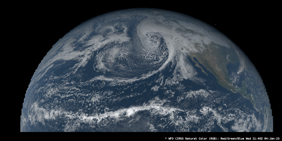
GOES-18 is Now GOES-West
GOES-18 - the newest satellite in the Geostationary Operational Environmental Satellite (GOES) series - is now the operational GOES-West satellite, replacing GOES-17 on January 4. As of that date, all data products from GOES-18 have permanently replaced those from GOES-17 on the Satellite Broadcast Network (SBN). This includes the following GOES-West data products:
- Sectorized Cloud and Moisture Imagery (SCMI);
- Level-2 (L2) derived products;
- Other products such as composite imagery
More information may be found on VLab and in the Service Change Notice SCN 22-113.
GOES-18 is operating as expected; the Loop Heat Pipe anomaly plaguing GOES-17 Advanced Baseline Imager (ABI) is not present on GOES-18. At the request of NWS, the GOES-R Program expedited the operational transition of GOES-18 to replace GOES-17.
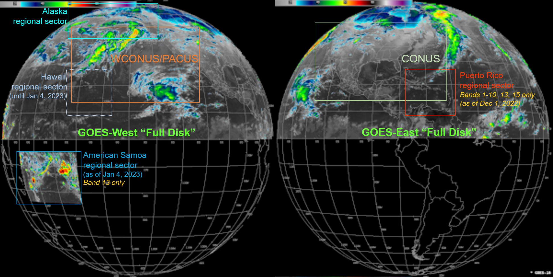
GOES SCMI Changes Over SBN
Several changes (referred to as “DO.11”) to Sectorized Cloud & Moisture Imagery (SCMI) products on the Satellite Broadcast Network (SBN) went into effect on Dec. 1 for GOES-East/GOES-16 and on Jan. 4 for GOES-West/GOES-18:
For both GOES-East and GOES-West:
- SCMI products denoted “Full Disk” cover only the Northern Hemisphere. (Among the NWS operations needing Southern Hemisphere imagery, few depend on the SBN for it.)
- Band 13 “Full Disk” imagery is provided at its full ground resolution (2 km). (“Full Disk” imagery for the other bands will remain at 6km resolution.)
For GOES-East:
- Imagery for the Puerto Rico Regional sector omits Bands 11, 12, 14, and 16.
For GOES-West:
- Imagery for the Hawaii Regional sector is omitted. (The Hawaii sector is largely covered by the West CONUS sector, which is scanned twice as often.)
- Band 13 Imagery for a new American Samoa Regional sector is available.
No changes are required in AWIPS for these changes, except for the new GOES-West American Samoa Sector activated on January 4, 2023. The TOWR-S team will work with the Pacific Region to ensure they have the required configurations to receive and display Band 13 in this new GOES-West sector.
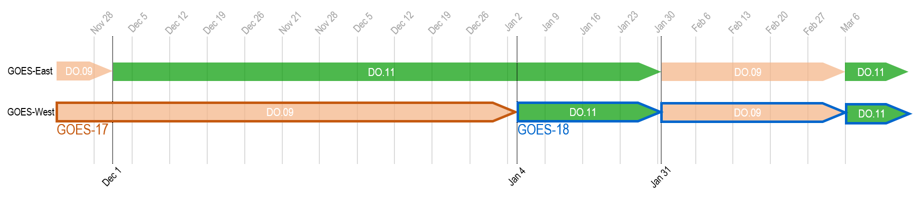
Both GOES-East and -West changes will revert temporarily on January 31 for 5 weeks, then become permanent on March 6, 2023. The timeline below reflects the deployment schedule; "DO.11" (green) represents when the changes listed above are in effect. More information can be found in Service Change Notice SCN22-94.
NOAA-21 Transition to Operations
In the late hours of December 15, 2022, engineers encountered an anomaly with the Ka-Band transmitter system aboard NOAA-21. As a result, no Science data has been available since. More information regarding the data outage can be found via OSPO.
JPSS-2 launched in the early hours of November 10, 2022. JPSS-2 was renamed NOAA-21 upon reaching orbit. It will be the tertiary satellite of the JPSS constellation, one quarter-orbit ahead of S-NPP. Once NOAA-21 is declared operational (at least 6 months post-launch in May 2023), it will become the secondary JPSS satellite, with S-NPP as the tertiary. Once NOAA-21 is declared the primary JPSS satellite (at least 9 months post-launch in Summer or Autumn of 2023), NOAA-20’s orbit will be shifted forward one quarter-orbit to a position opposite NOAA-21. More information can be found on the JPSS-2 Launch website.
“First light” images from the ATMS instrument were released on November 22, and from VIIRS on December 8.
The S-NPP satellite will remain operational after NOAA-21 is declared operational and at least until NOAA-21 is designated the primary satellite, as no formal guidance to decommission the satellite has been provided. S-NPP products will be provided by OSPO on a best effort basis. More information can be found in the JPSS-2 Product Operations Plan.
Himawari-9 Product Availability
Himawari-9 replaced Himawari-8 as the primary Japanese weather satellite on December 13. Himawari-8 and -9 are geostationary satellites observing the Pacific, with several imagery products being incorporated into AWIPS for use by Pacific and Alaska Region forecasters, among others. Due to the delayed delivery of Cloud Containerized Algorithms Packages (CCAPs), the NESDIS Common Cloud Framework (NCCF) is not yet producing Cloud, Winds, SST, or RainRate products from Himawari-9. The operational L2+ products are expected to be released in coming months, with Winds as the most immediate priority, to restore their availability to Pacific Region users. More information can be retrieved from OSPO.
Looking Ahead
Gridded GLM Products Coming to SBN in March 2023
The GOES-East and -West Geostationary Lightning Mapper (GLM) Gridded Data Products will become available over the SBN beginning on or after March 6, 2023. These products have been available to NWS field offices via Regional LDM.
These products provide three lightning parameters at each 4 km² grid cell:
-
Flash Extent Density (FED) - a measure of lightning flashes in a time interval;
-
Minimum Flash Area (MFA) - the smallest area - from about 64 km² to 2000 km² - a lightning flash covers during the time interval; and
-
Total Optical Energy (TOE) - the sum of all optical energy in the grid cell.
These products are provided as tiles covering the GLM Full Disk, at 1 minute and 5 minute time intervals. Starting in March, the 1-minute products will be available over the SBN; they will be removed from the Regional LDM feed soon thereafter. The 5-minute products will remain available via LDM.
All AWIPS sites will need to install the TOWR-S RPM v23 bundle of configurations (see below) to continue receiving and handling the GLM data products.
GLM grids report the vast majority of lightning in the Western Hemisphere. GLM was shown to improve lightning safety, severe thunderstorm and tornado warnings, safety and effectiveness of wildfire response, short term model forecasts (via data assimilation), precipitation estimation, tropical cyclone diagnosis and warning, and climate applications. These parameters provide a national and international baseline of publicly available lightning data and establish a baseline for widespread government and industry implementation and cooperation.
More information can be found in SCN 22-112.
TOWR-S RPM v23 Coming in February 2023
The TOWR-S team is preparing a set of AWIPS configurations to support several new data products and capabilities:
- GOES-R Gridded (1-minute) data from NESDIS;
- LightningCast probability products (received via NWS Regional LDM);
- “Day Fire” RGB composite (R: 3.9um (0-70C), G: 0.86um (0-100%), B: 0.64um (0-100%);
- VIIRS Flood Mapping products; and
- GOES Ice Concentration and Ice Thickness products.
These configurations, bundled as an installable “RPM” file (suitable for the Linux Redhat Package Manager), will undergo field testing after January 19, and will be made available to NWS sites after February 9.
As noted earlier, all AWIPS sites will need to install TOWR-S RPM v23 by March 6 to continue receiving and handling GLM data products.
SPADES Update Coming Soon
The Satellite Product Analysis and Distribution Enterprise System (SPADES) application receives GOES-R series space weather data in order to process and distribute forecast products to the Space Weather Prediction Center (SWPC).
The current and newly deployed release provided uninterrupted service when GOES-18 became GOES-West. Version 2.2.0 - which will contain support for the backup PDA interface and 16 additional algorithms - is slated to be operational later this year. This will allow SWPC to utilize the full range of products delivered from both GOES-16 and GOES-18 and maximize those products’ availability. The upcoming SPADES release, scheduled for FY23, will include all remaining L2 products and bring new capabilities to the SWPC forecasting mission.