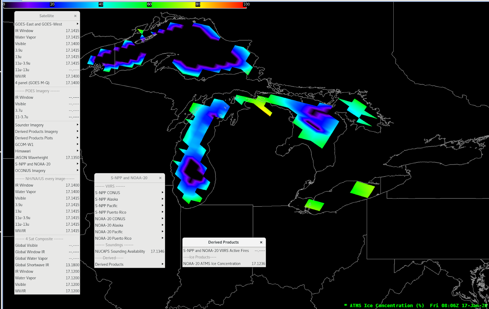
ATMS MiRS - Cryosphere Products

About 

The operational Microwave Integrated Retrieval System (MiRS) aims to upgrade the NESDIS current operational Microwave Surface and Precipitation Products System (MSPPS) and build a one-stop shop for microwave products from various satellites with different instrumental configurations. With the capability of providing optimal and physically-based retrievals of atmospheric and surface state parameters, the operational MiRS will produce advanced near-real-time surface and precipitation products in all-weather and over all-surface conditions using brightness temperatures from the microwave instruments. Ice Concentration, Snow Cover, Snow Fall Rate, and Snow Water Equivalent products are available by subscription from PDA (but not sent over SBN).

Limitations

Ground Resolution: The resolution varies greatly as the data points veer from nadir. Information from the outer edges of the viewing range is unreliable.

View Infrequency: A single area is only viewed twice per day.

Lag: Data refreshes every 90 minutes.

AWIPS 

Location: Satellite → S-NPP and NOAA-20 → Derived Products → ATMS Products

Color Maps: Grid/Gridded Data

Sampling: SIC: % ; SNOW: (binary); SFR: mm/hr; SWE : cm

Quality Flags: Qc: 0-good, 1-usable with problem, 2-bad

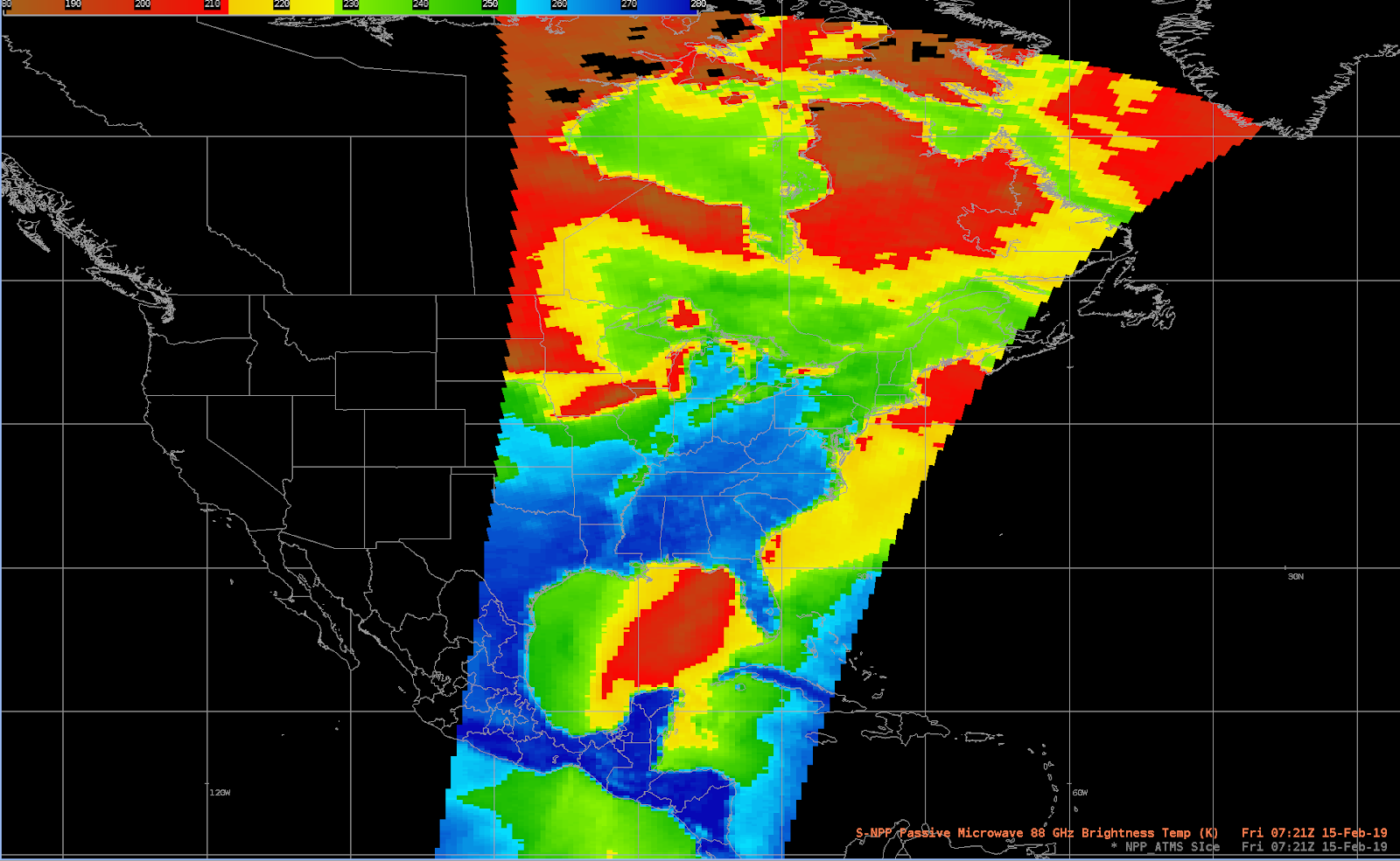
Technique: The Advanced Technology Microwave Sounder (ATMS) operates in conjunction with the CrIS to profile atmospheric temperature and moisture. Higher (spatial, temporal and spectral) resolution and more accurate sounding data from CrIS and ATMS support continuing advances in data assimilation systems and NWP models to improve short- to medium-range weather forecasts.

AWIPS Technical Details

Sector 33-minute granules (3 granules/orbit); 2600km swath width
Refresh Rate 1.5hr/11hr global
Size ~2.98 GB/day per satellite
Resolution 15 km nadir
Data Source NDE → PDA
Projection None (lon/lat positions)
Storage Location N/A
WMO Header N/A
Product Short Name NPR-MIRS-IMG
Data Path Data Delivery
AWIPS Configuration TOWR-S RPM v22
AWIPS Plugin Pointset
Edex Purge Rule 1 day default

Use Cases & More

MiRS Snow Depth and SWE in Alaska - C. Dierking, JPSS/GOES-R PG/RR Summit, 2020

MiRS: Great Lakes Ice Detection - P. Ayd, Polar Satellite data products: Use cases and AWIPS implementations, April 10, 2020

More information can be retrieved from STAROSPOCIRA, and GINA.

Point of Contact: Quanhua (Mark) Liu

Feedback Form

Submit questions and suggestions for the TOWR-S pages using this short form.

This page was last updated on March 26, 2024.