GOES Fire Hot Spot

About 

The GOES-R Fire/Hot Spot Characterization consists of Fire Area, Fire Power and Fire Temperature products, along with Product Flags. It relies upon different sensitivities in Band 7 (3.9 μm) and Band 14 (11.2 μm) to high temperature anomalies from fires allowing the detection of fires and their characteristics such as size, temperature, and intensity.

Limitations

Cloud Visibility: Undetected water cloud or smoke contamination can affect fire detection and characterization.

Viewing Angle: Fire detection accuracy decreases and image distortion increases as the viewing angle approaches 80 degrees. Viewing angles greater than 80 degrees are not useful.

Pixel Size: Detection pixels may only be seen for a portion of the fire rather than the entire fire. Very small fires may be undetected.

AWIPS 

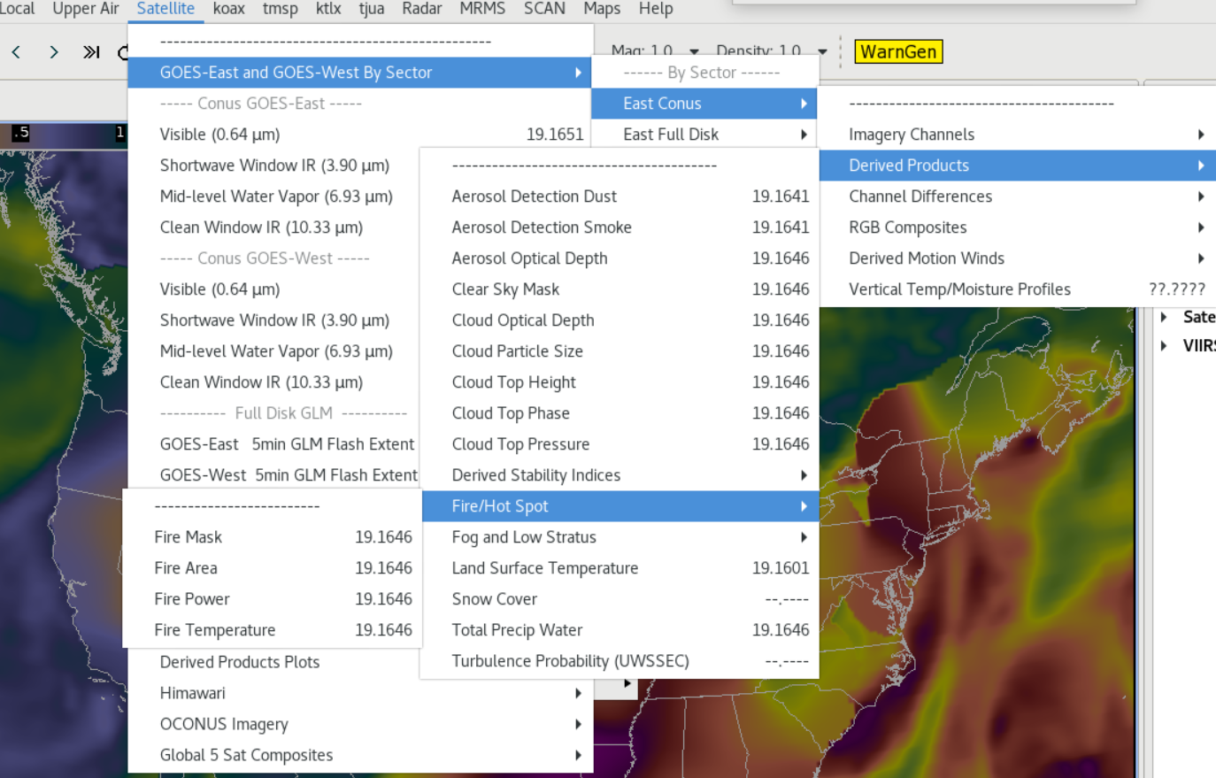
Location: Four different parameters are available. GOES-East and GOES-West By Sector → choose sector → Derived Products → Fire/Hot Spot → [Fire Mask | Fire Area | Fire Power | Fire Temperature]

Color Maps: The Fire Mask uses the colormap: GOES-R/GOESR-L2/fire_mask3 (TOWR-S RPM v21+);

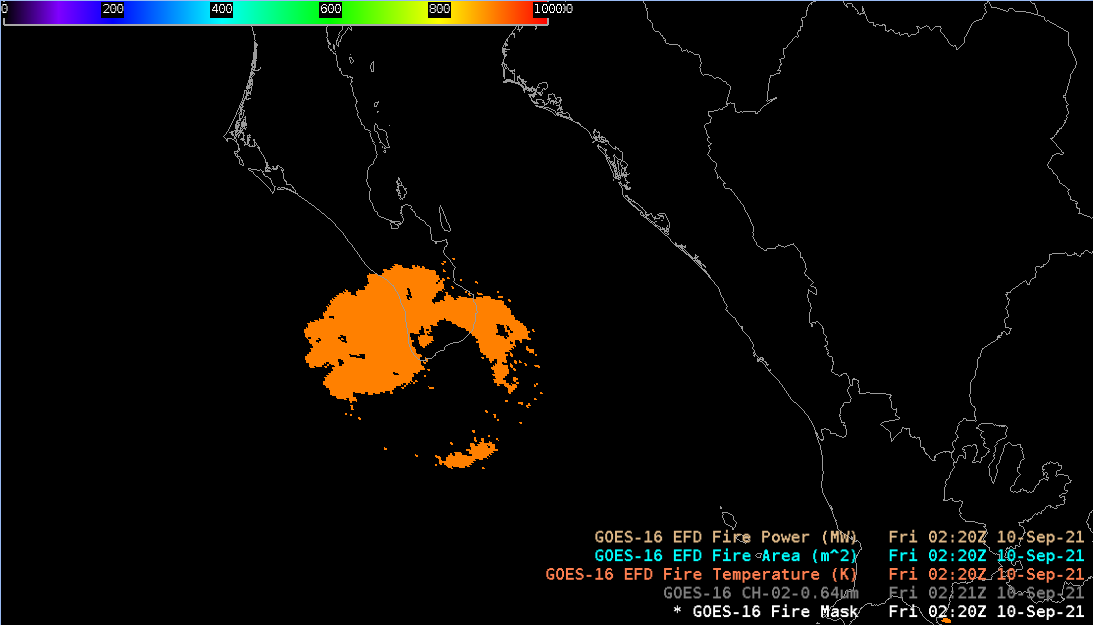
Fire Area, Fire Power, Fire Temperature use the colormap: GOES-R/GOESR-L2/VTRSB (baseline)

Sampling: Fire Mask is sampled by characteristic, e.g. High Probability Fire. Fire Area: square meters. Fire Power: MW. Fire Temperature: K

Quality Flags: Fire Area, Fire Power, Fire Temperature: good quality pixels are retained

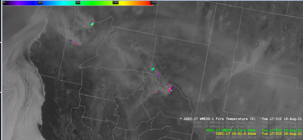
Technique: Product flags (‘Fire Mask’) from the algorithm are included to help forecasters interpret the output. The fire mask has been recently implemented as of TOWR-S RPM Version 21. It shows identified lower confidence fires, and provides a measure of confidence that signatures are associated with true wildland fire. The mask products provide a measure of confidence stated as Low, Medium, High, as well as a few other detection categories such as "cloudy fire.” For example, this product can be used in conjunction with the 3.9 um (Ch 07) band, overlaying the Fire Mask or other fields on top of the imagery with sampling turned on to detect changes in fire location or intensity.

AWIPS Technical Details

Sector Full Disk, CONUS, Mesoscale 
Refresh Rate 10 min, 5 min, 1 min
Size ~40 megabytes per hour GOES-East; ~34 megabytes per hour GOES-West
Horizontal Resolution 2km at nadir
Data Source SBN EXP
Projection GOES-R Fixed Grid
Storage Location
(processed)
dx2:/awips2/edex/data/hdf5/satellite/<sector>/[FDC Area | FDC Power | FDC Temp | Fire Mask]
WMO Header IXTJ99 KNES for GOES-East;  IXTJ89 KNES for GOES-West
Product Short Name OR_ABI-L2-FDC[F|C|M1|M2]
Data Path (raw) /data_store/goes-r/yyyymmdd/hh/IXTJ* for SBN Full Disk and Conus.  The LDM mesos flow to the same dir and begin with  OR_ABI-L2-FDCM
AWIPS Configuration TOWR-S RPM v22
AWIPS Plugin goes-r
Edex Purge Rule 24 hours (baseline)

Use Cases & More

ABI Fire Detection - C. Schmidt, Satellite Book Club #54, June 17, 2021

More information can be retrieved from VLab Quick Guide, GOES-R, and GOES Fact Sheet.

Point of Contact: Chris Schmidt

Feedback Form

Submit questions and suggestions for the TOWR-S pages using this short form.

This page was last updated on March 26, 2024.