


Satellite Operations Updates - Total Operational Weather Readiness - Satellites (TOWR-S)
NOAA-21 Transition to Operations (T2O) - Summer 2023 Update
About NOAA-21 and JPSS
The Joint Polar Satellite System (JPSS) is the nation’s advanced series of polar-orbiting environmental satellites. JPSS satellites circle the Earth from pole-to-pole and cross the equator 14 times daily in the afternoon orbit, providing full global coverage twice a day. The JPSS constellation currently consists of the Suomi National Polar-Orbiting Partnership satellite (S-NPP) launched in 2011, NOAA-20 (formerly JPSS-1) launched in 2017, and NOAA-21 (formerly JPSS-2) launched November 10, 2022. These satellites carry several instruments of interest to forecasters: namely the Visible/Infrared Imager Radiometer Suite (VIIRS), the Advanced Technology Microwave Sounder (ATMS), the Cross-track Infrared Sounder (CrIS), and the Ozone Mapping and Profiler Suite (OMPS).
The NOAA-20, NOAA-21, and S-NPP satellites are on a low-earth, sun-synchronous orbit slightly more than 100 minutes long; each crosses the equator at 13:30 local solar time in the northbound direction (ascending node), and at 01:30 local solar time in the southbound direction (descending node). As visualized in the image below, NOAA-20 and S-NPP are at opposite points on this orbit. While NOAA-21 is the tertiary satellite in the constellation, it is directly between them, one quarter-orbit ahead of S-NPP. Together they provide VIIRS imagery for most of the globe at least six times per day (three in the daytime; three more at night). In mid- and northern latitudes, given the overlap among VIIRS swaths, many CONUS locations are sensed 8 or 9 times a day (between the three satellites); and parts of Alaska 16-20 times per day. Upon NOAA-21 becoming the primary satellite in the constellation, NOAA-20 will shift in orbit to be directly opposite NOAA-21, with S-NPP between them.
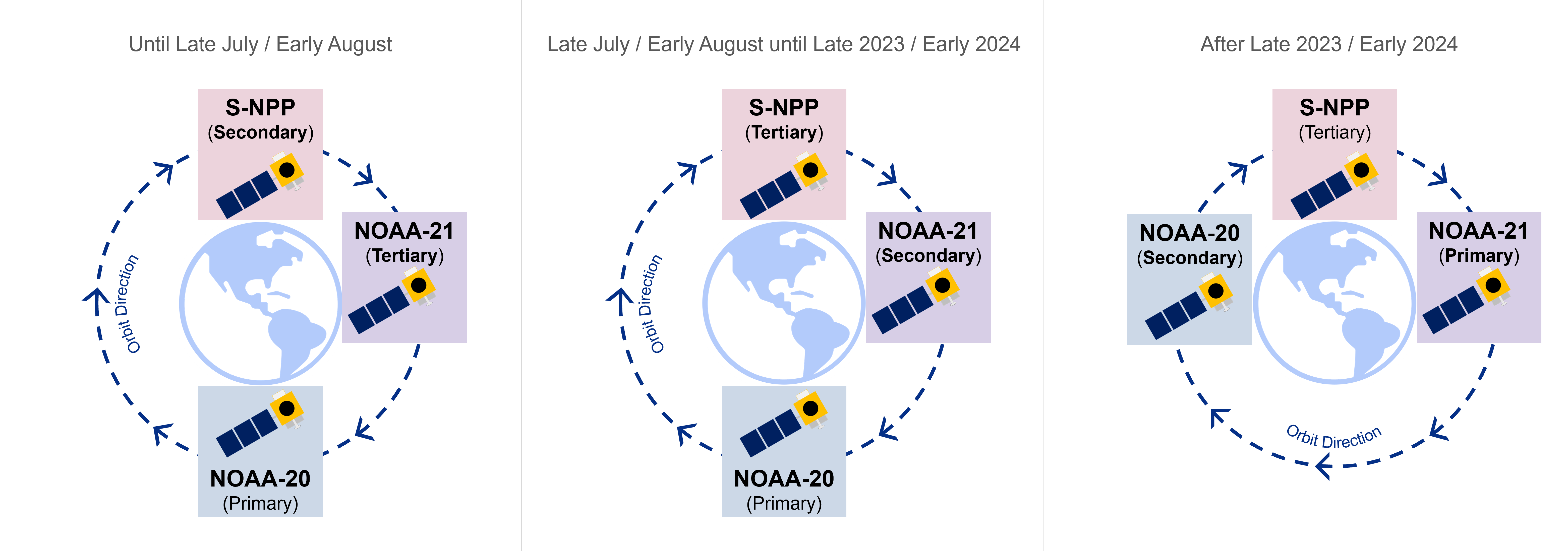
The satellites are operated in prioritized order. NOAA-21 is currently the tertiary satellite of the constellation. (The primary and secondary satellites take precedence in data processing and spacecraft maneuvers.) NOAA-21 will be designated as the secondary satellite in late July or August 2023 (at which time S-NPP will become tertiary). NOAA-21 will likely become the primary JPSS satellite in early 2024.
Summary of Events Before July 2023
“First light” images from the ATMS instrument were released on November 22, and from VIIRS on December 8, 2022. ATMS was declared ready for operations on December 15.
However in mid-December, NOAA-21’s primary Ka-Band transmitter stopped sending Stored Mission Data (SMD) to NOAA’s ground system. Fortunately its secondary Ka-Band transmitter was successfully initiated on February 2, 2023, and has performed well. With the transmitter anomaly resolved, the NOAA-21 team resumed preparation of the instruments onboard and Post-Launch Testing (PLT).
“First light” images from the CrIS instrument were released on February 16. On March 30, NOAA’s Office of Satellite Product Operations (OSPO) assumed responsibility for operating the NOAA-21 satellite. On the same day, OSPO declared NOAA-21’s VIIRS imagery products and CrIS SDRs to be ready for operations. OMPS SDRs were declared ready for operations on April 19, with EDRs in Beta Maturity.
VIIRS Sea Surface Temperature, ATMS MiRS and SnowFall Rate products reached Beta Maturity in May. MiRS was declared Provisional in June, and ATMS Level 1 products were fully validated on June 22. NUCAPS products from ATMS/CrIS reached Beta Maturity in June, with VIIRS Active Fires, Aerosol Optical Depth and Particle Size Parameter products declared provisional as well.
NOAA-21 in AWIPS
CONUS WFOs and RFCs
NOAA-21 VIIRS Day-Night Band Near-Constant Contrast (NCC) imagery for CONUS, Puerto Rico, and Pacific regions will become available in AWIPS through the Satellite Broadcast Network (SBN) on or after July 10. More information is available in SCN 23-64. TOWR-S is working with test sites to install menu entries for NOAA-21. Other AWIPS sites will find both S-NPP and NOAA-21 imagery in the menu entries for S-NPP until they install the next TOWR-S RPM update (v24), to become available in August.
VIIRS Active Fires will be sent via NWS Regional LDM, with VIIRS Flood Maps, NUCAPS, Blended Hydro, and other undetermined products to be disseminated over SBN later this Fall/Winter.
Pacific Region
NOAA-21 data products are being disseminated to Pacific Region from Direct Readout antennas, with HQ evaluating them in AWIPS. The Guam Direct Readout system is undergoing updates to allow AWIPS integration of NOAA-21 data.
National Centers
Most centers are receiving NOAA-21 data from direct PDA subscriptions, though some (e.g. NHC) rely on ISatSS for postprocessing for NAWIPS.
Alaska
NOAA-21 data products are being ingested by Direct Readout antennas, and processed with the Community Satellite Processing Package (CSPP) v4.0. The resulting products are being disseminated from the Geographic Information Network of Alaska (GINA) to Alaska Region field offices. Data flows of VIIRS imagery from the processing system at NWS/Anchorage (Regional HQ) are also commencing. The NESDIS PDA system is also disseminating VIIRS imagery Key Performance Parameters (KPPs) to Alaska HQ.
NWS Operational Test and Evaluation (OT&E)
OT&E is done to validate operational requirements independently from end to end in a live environment, and advise the recommendation for full deployment to forecast operations. 6 sites have been chosen for testing: Alaska Region HQ, WFO Medford (Oregon), WFO Gaylord (Michigan), WFO Houston/Galveston, WFO Buffalo, and RFC Portland (Oregon).
VIIRS imagery for Alaska via Direct Readout, VIIRS KPP imagery, and VIIRS NCC imagery for CONUS, Pacific, and Puerto Rico via SBN will undergo testing throughout August and September. VIIRS imagery from NOAA-21 in its new orbit pattern, and Blended Hydro products will be evaluated throughout December 2023. Finally the NUCAPS soundings will be evaluated throughout February 2024.
More information can be found in the TOWR-S Update Slides, SCN 23-64, the NOAA-21 Post-launch Product Validation Schedule, the JPSS Algorithm Maturity Matrix, and the Product Operations Plan.