GOES Cloud Cover Layers

About 

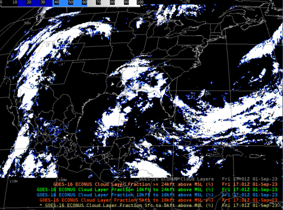
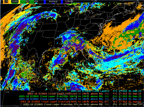
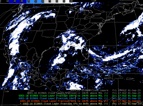
The Cloud Cover Layers (CCL) product is an estimation of the cloud fraction between predefined atmospheric levels, as well as the total cloud fraction. This 5-layer product is particularly beneficial for aviation, as the classification is in Flight Layers. The 5 layers are from Above Mean Sea Level (AMSL) to Flight Layer (FL) at 5,000 ft (AMSL-FL050), from FL at 5,000 ft to 10,000 ft (FL050-FL100), from FL at 10,000 ft to 18,000 ft (FL100-FL180), from FL at 18,000 ft to 24,000 ft (FL180-FL240), and from FL at 24,000 ft to top of the atmosphere (FL240-TOA). The algorithm also produces a cloudy/clear layer flag at pixel level for each layer. The layer flag is stored using bit structure in a one byte number.

Limitations

Layer Classification Accuracy: The accuracy for classifying the correct cloud layer per the product requirements is 60%.

AWIPS Capabilities: The CAVE environment does not visualize in three dimensions, therefore the CCL produced for AWIPS has been modified from its original format.

AWIPS 

Location: GOES-East and GOES-West By Sector → choose sector → Derived Products → Cloud Layers

Color Maps: ccl.cmap

Sampling: Total Cloud Fraction          0.0 - 1.0 (scaled integers)
Cloud Fraction %:           < 5 kft elevation 0 - 100 (integers)
Cloud Fraction %:           5-10 kft 0 - 100 (integers)
Cloud Fraction %:           10-18 kft 0 - 100 (integers)
Cloud Fraction %:           18-24 kft 0 - 100 (integers)
Cloud Fraction %:           > 24 kft 0 - 100 (integers)
Binary Cloud Layer Flags           00000 - 11111 (5 bits)

Quality Flags: Inherited from Algorithm Working Group Cloud Height Algorithm (ACHA). Good quality flag mask (DQF=0) is used for each cloud layer field.

Technique: CCL may be used to determine areas of cloud growth and likelihood of precipitation. The product is also useful for assessing Ceiling & Visibility, and composing Terminal Aerodrome Forecasts (TAFs) at various altitudes.

AWIPS Technical Details

Sector Full Disk, CONUS, and Mesoscale
Refresh Rate Full Disk: 1 hr; CONUS: 5 min; Mesoscale: 5 min
Size Full Disk: 24 files or 0.05 GB per day per satellite
CONUS: 288 files or 0.13 GB per day per satellite
Mesoscale: 576 files or 0.13 GB per day per satellite
Resolution Full Disk, CONUS: 10km nadir
Mesoscale: 4 km nadir
Data Source PDA
Projection GOES-R Fixed Grid
Storage Location /data_store/goes-r
WMO Header GOES-East: IXTC99 KNES; GOES-West: IXTC89 KNES
Product Short Name OR_ABI-L2-CCL
Data Path NOAAport/SBN (EXP Channel)
AWIPS Configuration TOWR-S RPM v24
AWIPS Plugin goes-r
Edex Purge Rule 24 hours (baseline)

Use Cases & More

More information can be retrieved from the ATBD, NOAASIS, PS-PVR NWS Perspective, and SCN 23-93.

Point of Contact: Mark Kulie

Feedback Form

Submit questions and suggestions for the TOWR-S pages using this short form.

This page was last updated on March 26, 2024.