NUCAPS

Metop-C NUCAPS coming in March 2024, NOAA-21 NUCAPS coming later in Spring 2024

About 

NUCAPS (the NOAA-Unique Combined Atmospheric Processing System) combines observations from the Cross-track Infrared Sounder (CrIS) and Advanced Technology Microwave Sounder (ATMS) aboard NOAA's JPSS, and EUMETSAT's Metop polar-orbiting satellites.

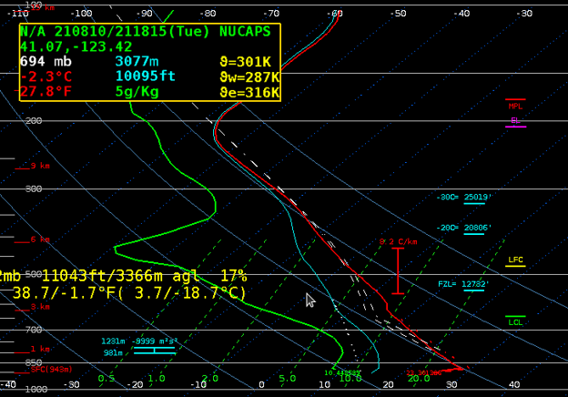
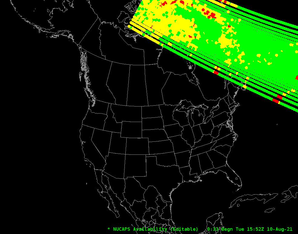
NUCAPS data consist of vertical atmospheric profiles detailing the temperature and moisture at multiple elevations. AWIPS displays locations of available soundings, color-coded based on their cloud cover.

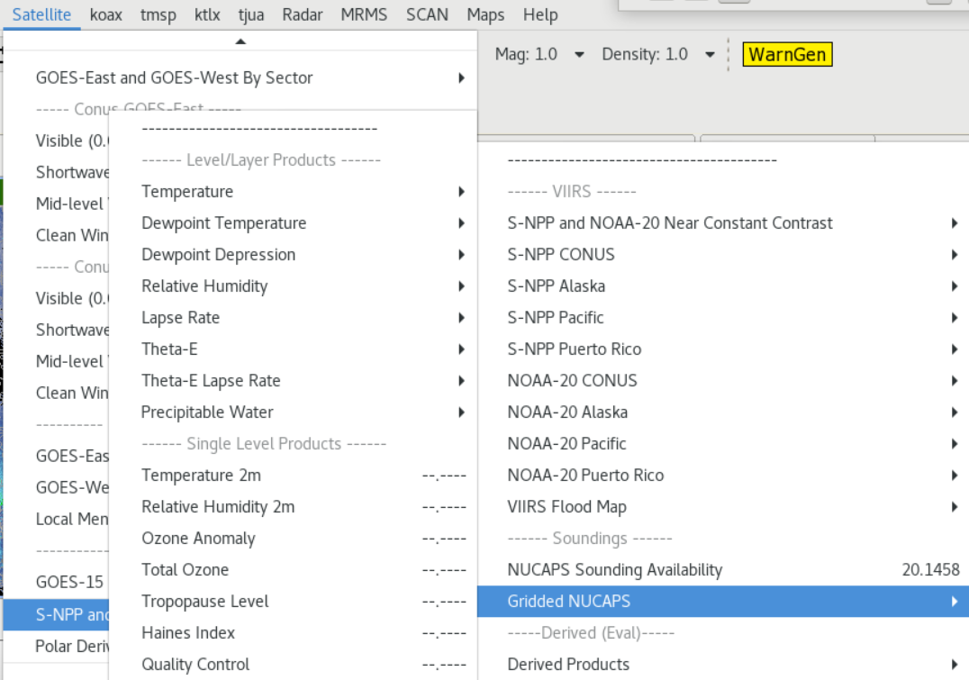
AWIPS users can display a Skew-T plot for any selected data point to highlight unstable or pre-convective conditions. Additionally, AWIPS can interpolate 2D gridded views of various parameters including temperature, dewpoints, relative humidity, and precipitable water across multiple soundings at any of 9 elevations, as well as near-surface Temperature and Humidity, Total Column Ozone, Tropopause Level, and Haines Index.

Limitations

Cloud Visibility: Cloud cover degrades NUCAPS estimates of atmospheric conditions.

Satellite Platform: AWIPS no longer receives NUCAPS data from S-NPP.

AWIPS 

Location: Satellite → JPSS Polar → NUCAPS Sounding Availability

Satellite → JPSS Polar → Gridded NUCAPS

Color Maps: Sounding availability due to cloud cover: green=good; yellow=marginal (Microwave only); red=no retrieval

Sampling: N/A

Quality Flags: N/A

Technique: NUCAPS has the potential to support basic and applied geophysical science research/investigation, direct broadcast, nowcasting and Scientific Data Record (SDR) monitoring. Near real-time retrievals of NUCAPS temperature and moisture profiles can aid in warnings of severe weather, for example atmospheric stability conditions for tropical storms as well as for tornado warnings. For the latter retrieval products of higher spatial resolution (~10km) are needed. Additionally, NUCAPS trace gas products can be useful to air quality forecasting and climate studies.

AWIPS Technical Details

Sector

NOAA-20/21: 30-second granules (200 granules/orbit); 3600km swath width; (BUFR regions 01-09)

Metop-C: 3-minute granules (34 granules/orbit); 2,100 km swath width (BUFR regions 01-09)

Refresh Rate

NOAA-20/21: each ~1,800 files/day; 0-100 files/hour.

Metop-C: 300 files/day for Regions 01-09; 0 to 17 files/hour

CONUS latitudes: typically 2 passes from each of the two JPSS satellites, at 0200-0400 and again 1400-1600 local solar time. Metop-C overpasses are around 9:00 and 21:00 local time. More frequent overpasses in higher latitudes; fewer south of CONUS latitudes.

Size

NOAA-20/21: 212KB per 30-second granule

Metop-C: 867KB per 3-min granule

Horizontal Resolution 50-135km between profiles
Data Source NOAA-20/21 → IDPS → NDE; Direct Broadcast via CIMSS or GINA
Projection

NOAA-20/21: Each 30-second granule has 120 profiles with 101 pressure levels

Metop-C: Each 3-min granule has 660 or 690 profiles with 101 pressure levels

Storage Location /data_store/nucaps/yyyymmdd/hh
WMO Header

NOAA-20/21: IUTN1[1-9] KNES

Metop-C: IUTN0[1-9] KNES

Product Short Name

NOAA-20/21: NUCAPS_EDR_IUTN1[1-9]_KNES

Metop-C: NUCAPS_EDR_IUTN0[1-9]_KNES

Data Path PDA → NCO → NCF → SBN (NMC3 channel)
AWIPS Configuration styleRules/nucapsImageryStyleRules.xml (gridded NUCAPS)
AWIPS Plugin NUCAPS (sounding availability -> Skew-T plots); Also Gridded NUCAPS
Edex Purge Rule 24 hours (baseline)

Use Cases & More

Gridded NUCAPS - E. Berndt, Satellite Book Club #13, August 13, 2020

Severe Weather - C. Shultz, STAR 2020 Workshop, February 2020

More information can be retrieved from STAR, OSPO, CIRA, GINA, the End-User Manual, and this training module

Point of Contact: Awdhesh (AK) Sharma, Ken Pryor, Murty Divakarla

Feedback Form

Submit questions and suggestions for the TOWR-S pages using this short form.

This page was last updated on March 26, 2024