


Satellite Operations Updates - Total Operational Weather Readiness - Satellites (TOWR-S)
November News
Updated November 22, 2022
Recent Updates
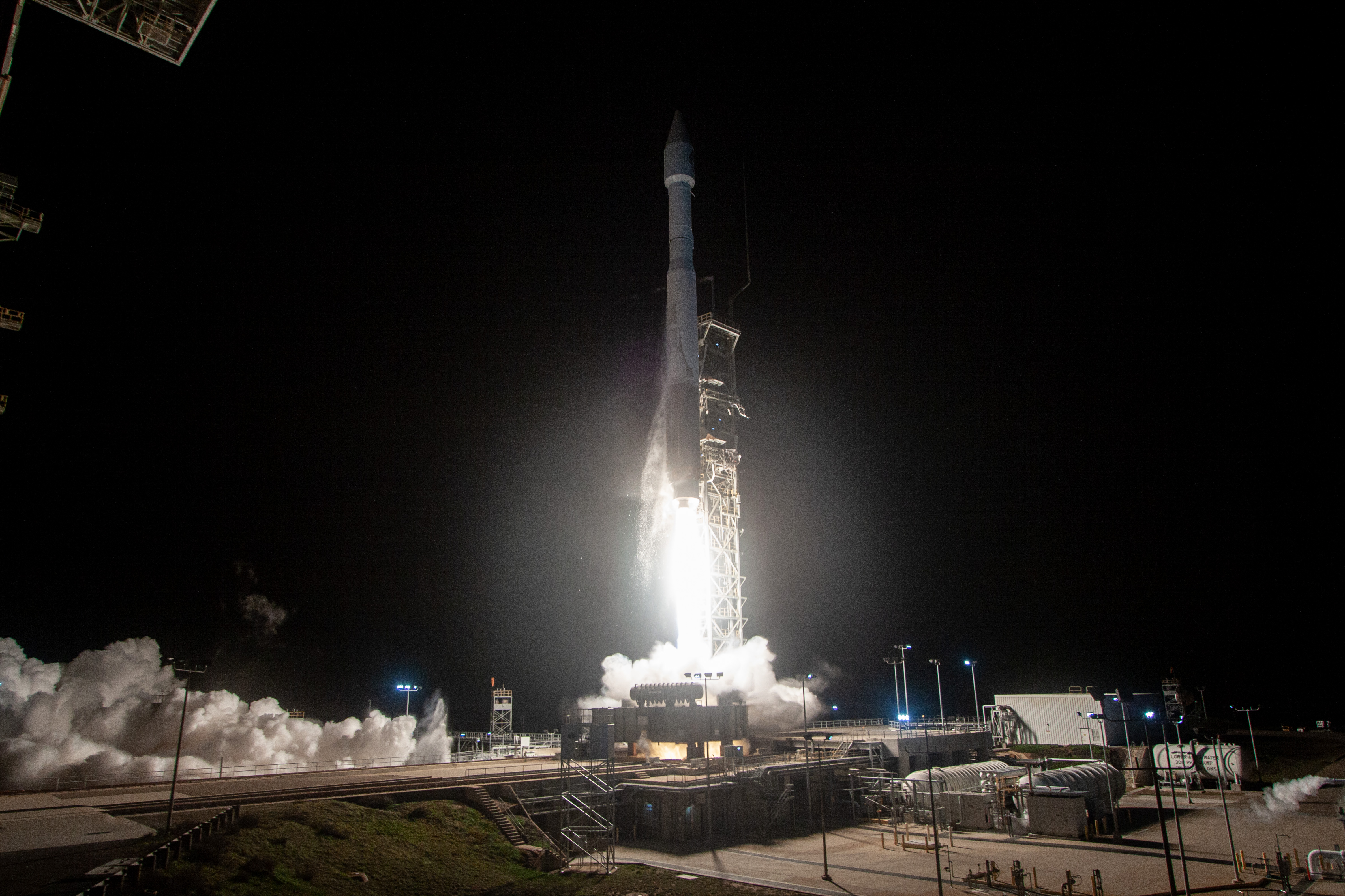 JPSS-2/NOAA-21 Launched
JPSS-2 launched in the early hours of November 10, 2022. JPSS-2 was renamed NOAA-21 upon reaching orbit. It will be the tertiary satellite of the JPSS constellation, one quarter-orbit ahead of S-NPP. Once NOAA-21 is declared operational (at least 6 months post-launch in May 2023), it will become the secondary JPSS satellite, with S-NPP as the tertiary. Once NOAA-21 is declared the primary JPSS satellite (at least 9 months post-launch in Summer or Autumn of 2023), NOAA-20’s orbit will be shifted forward one quarter-orbit to a position opposite NOAA-21.
“First light” images from NOAA-21’s 6 instruments will be released beginning this month and into December. Operational science data product validation will also begin this month, and will continue into CY23. More information can be found on the JPSS-2 Launch website.
The S-NPP satellite will remain operational after NOAA-21 is declared operational and at least until NOAA-21 is designated the primary satellite, as no formal guidance to decommission the satellite has been provided. S-NPP products will be provided by OSPO on a best effort basis. More information can be found in the JPSS-2 Product Operations Plan.

GOES-18 in Final Interleave, Ends Nov 16
From October 13 until November 16, the GOES-18 Advanced Baseline Imager (ABI) provided operational L1b radiances and imagery in place of the GOES-17 ABI on the Satellite Broadcast network (SBN) and the GOES Rebroadcast (GRB). All other GOES-West products on these channels -- including ABI L2+ products on SBN and Space Weather observations on GRB -- continue to come from GOES-17. GOES-18 ABI data obtained through the SBN or GRB during this period should be treated as nominal GOES-West operational data. World Meteorological Organization (WMO) headers and SBN channels remain the same. For AWIPS users, “GOES-18” appears in the legend of imagery bands selected in CAVE. More information can be found in the Service Change Notice (SCN), the notice from NESDIS, and the GOES-18 T2O page.
GOES-17 ABI No Longer in Mode 3 Cooling
The GOES-17 satellite ended its final Mode 3 Cooling at 1200 UTC on November 15. Mode 3 included the following changes for 6 hours each day (0600-1200 UTC):
- Full Disk data products are produced only every 15 minutes (including Hawaii and Alaska regional sector products);
- Mesoscale Sector data products alternate each minute, each Mesoscale Domain (Meso1/2) has new data every-other minute;
- CONUS/PACUS products are not produced
This is the final instance of GOES-17 Mode 3 Cooling. GOES-17 will be taken out of service once GOES-18 is declared operational as GOES-West on January 4, 2023. See below for more information on the GOES-West operational transition.
GOES-18 L2+ Products Under Evaluation
Several GOES-18 Advanced Baseline Imager (ABI) Level 2 and higher (L2+) science products are being evaluated for Provisional maturity (readiness for operations) through Autumn 2022:
| Aerosol Detection (Smoke & Dust) | Derived Motion Winds | Legacy Vertical Moisture Profile |
| Aerosol Optical Depth | Derived Stability Indices | Legacy Vertical Temperature Profile |
| Clear Sky Mask | Downward S/W Radiation: Surface | Rainfall Rate/QPE |
| Cloud Optical Depth | Fire/Hot Spot Characterization | Reflected S/W Radiation: TOA |
| Cloud Particle Size Distribution | Ice Age & Thickness | Sea Surface Temperature |
| Cloud Top Height | Ice Concentration & Extent | Snow Cover |
| Cloud Top Phase | Land Surface Albedo | Total Precipitable Water |
| Cloud Top Pressure | Land Surface Reflectance | |
| Cloud Top Temperature | Land Surface Temperature |
When GOES-18 becomes GOES-West on January 4, 2023, many of these products will be disseminated over the Satellite Broadcast Network (SBN), replacing their GOES-17 counterparts. All products will be evaluated for Full Validated Maturity during CY2023.
Looking Ahead
GOES-18 to Become GOES-West Jan 4, 2023
On or near Jan. 4, 2023, GOES-18, the newest satellite in the Geostationary Operational Environmental Satellite (GOES) series, will become the operational GOES-West satellite, replacing GOES-17. As of that date, all data products from GOES-18 will permanently replace those from GOES-17 on the Satellite Broadcast Network (SBN). This will include the following GOES-West data products:
- Sectorized Cloud and Moisture Imagery (SCMI);
- Level-2 (L2) derived products;
- Other products such as composite imagery
GOES-18 is operating as expected; the Loop Heat Pipe anomaly plaguing GOES-17 Advanced Baseline Imager (ABI) is not present on GOES-18. At the request of NWS, the GOES-R Program has expedited the operational transition of GOES-18 to replace GOES-17.
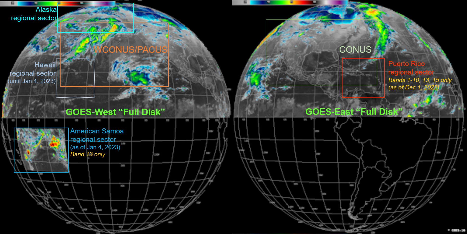
GOES SCMI Changes Over SBN
In December 2022 and January 2023, several changes (referred to as “DO.11”) are coming to Sectorized Cloud & Moisture Imagery (SCMI) products on the Satellite Broadcast Network (SBN). These changes will go into effect on Dec. 1 at approximately 18Z (for GOES-East / GOES-16) and Jan. 4 (for GOES-West / GOES-18):
For both GOES-East and GOES-West:
- SCMI products denoted “Full Disk” will cover only the Northern Hemisphere. (Among the NWS operations needing Southern Hemisphere imagery, few depend on the SBN for it.)
- Band 13 “Full Disk” imagery will be provided at its full ground resolution (2 km). (“Full Disk” imagery for the other bands will remain at 6km resolution.) This won't impact current AWIPS procedures, RGBs, or Channel Differences.
For GOES-East:
- Imagery for the Puerto Rico Regional sector will omit Bands 11, 12, 14, and 16.
For GOES-West:
- Imagery for the Hawaii Regional sector will be omitted. (The Hawaii sector is largely covered by the West CONUS sector, which is scanned twice as often.)
- Band 13 Imagery for a new American Samoa Regional sector will become available.
(The DO.11 changes will not be applied to GOES-17 before it is taken out of service.)
Both GOES-East and -West changes will revert temporarily for the month of February, 2023; but will become permanent on March 6, 2023. The timeline below reflects the deployment schedule; DO.11 represents the changes listed above and DO.10 represents the current status. More information can be found in the Service Change Notice (to be updated shortly with the revised dates).

Implications for AWIPS: No changes are required in AWIPS for these upcoming SBN changes with the exception of GOES-West and the new American Samoa Sector. The TOWR-S team is working with Pacific Region to ensure they have the required configurations for this new sector.
OceanSat-3 from ISRO to Launch Soon
According to the latest and best estimates, the Indian Space Research Organisation (ISRO) will launch OceanSat-3 in November, 2022. OceanSat-3 is a polar-orbiting satellite with 3 sensors dedicated to marine observations; in particular a Scatterometer (OSCAT-3) which will complement observations by ASCAT and others.
Himawari-9 Transition
Himawari-9 will replace Himawari-8 as the primary Japanese weather satellite on December 13 2022. Live testing will be performed in the weeks preceding the transition. Himawari-8 and -9 are geostationary satellites observing the Pacific, with several imagery and L2 science products being incorporated into AWIPS for use by Pacific Region forecasters and others. TOWR-S is working with the NWS Pacific Region, the University of Wisconsin, and NESDIS’ Center for Satellite Applications and Research (STAR) to ensure end-to-end readiness for this transition. More information can be found on the JMA website.
VIIRS Flood Mapping Coming Soon
NESDIS released an operational VIIRS Flood Map product in July. After confirming its configuration and performance with a few AWIPS test sites over the coming weeks, this product may be disseminated to additional AWIPS sites via LDM.