


III. FAQs and Known Issues - Total Operational Weather Readiness - Satellites (TOWR-S)
III. FAQs and Known Issues
1. Users reported issues displaying the global blended hydrology (polar sat) and multi-sat geostationary products on the Geostationary maps. It is recommended to unload and/or re-start CAVE using other base scales (e.g. World mercator).
2. The NOAA-20 imagery products will show a legend (bottom right) as "S-NPP VIIRS" instead of "NOAA-20 VIIRS." This is currently coded into the VIIRS plugin and an update to the code and/or configurations has not yet been completed. However, a ticket has been written (DR #20708) and these updates should appear in a subsequent baseline release.
3. When Legacy GOES-15 is turned on: If the Legacy GOES-15 (IR Window, VIS, Water Vapor) do not update under "Satellite" (or do not show the CONUS scale), following this RPM install, then your site may have over-rides at the Configured localization for the satellite cave menus. (Note: GOES-15 populates under the Legacy section in the towr-s RPM, and is only activated during limited times associated w/the GOES-17 loop heat pipe anomaly). I.e., the key settings for sector may be reversed from the baseline (the TOWR-S RPM expects the baseline).
To check this, under the localization perspective in CAVE, select the Menus folder, then drop open the baseComposite.xml file. Check to see if there is a "Configured (<site_name>)" xml file. If so, and if the keys are set to:
East CONUS --> sector0
West CONUS --> sector1,
Then the TOWR-S RPM bundle file will not correctly render the GOES-15 satellite products in the menu (the baseline baseComposite.xml file has these reversed). This configuration file which controls this setting can be modified by opening a terminal (e.g. on dx1) and going to: /awips2/edex/data/utility/cave_static/configured/<site_name>/menus/satellite/baseComposite.xml (assuming this file is present).
Edit the file so that it assigns keys as:
East CONUS --> sector1
West CONUS --> sector0,
(Alternatively, move the file out of the /awips2 dir structure).
Then, restart CAVE. The GOES-15 (IR Window, VIS, Water Vapor) buttons should light up with current time stamps.
4. One site recently found (summer 2020, v18.5) that in accomplishing the RPM remove and install steps, he needed to add --disablerepo=awips2repo to the yum commands.
5. When displaying the VIIRS Active Fires product (LDM feed) for the first time (available RPM v20), an alertviz banner may appear associated with a sampling configuration. This anomaly occurs (should occur) only once at initial display of the product for the first time, and is fixed by a cave re-start.
6. (Nov 2020) Some of the NOAA-20 ATMS derived products (Cloud Liquid Water, Snow, Total Precipitable Water), whose configurations are available beginning in towr-s RPM v20, have issues when displaying at the Norther polar stereographic scale. This tends to occur when the orbit has most of the data points near the south pole. The current work-around is to use a lat-lon (world view), Conus, or geostationary view for these products. (aside: The data flow for these products, in addition to those of the AMSR2 MW imagery and sea surface wind speed, will be available via data delivery in the near future).
7. (Nov 2020) The Gridded NUCAPS aren't displaying. Check to make sure you have the cave gridded NUCAPS plugin installed on the lx, which is a baseline plugin. There should be for instance, a file: /awips2/cave/plugins/gov.noaa.nws.sti.mdl.viz.griddednucaps_*.jar, or try ls *griddednucaps*.jar. If there is no jar file contact the NCF. Version 20 of the towr-s RPM contains all of the menus and bundle xml files for the gridded nucaps plugin as part of some menu/bundle corrections provided by SpORT (exception is the Volumebrowser entry for gridded nucaps), but the plugin itself needs to be installed.
8. (Nov 2020) Note for Early Eval sites (installing 20.0), 11/16/2020 - 11/19/2020 only. If you have installed 20.0, there will be an alert banner returned under Satellite-> GOES-15 Imagery (Legacy)-> NH/NA/US Imagery (Legacy). This is for legacy imagery that populates the menu during periods when GOES-15 is turned on for GOES-17 Loop Heat Pipe mitigation. This menu error is fixed by doing the following steps a. and b.:
a. As user awips on dx1, type the following command from a terminal window:
rm /awips2/edex/data/utility/cave_static/site/<your_site-3-letter>/menus/satellite/baseNHemisphere.xml
(substitute your 3-letter site-ID, e.g. LWX in place of <your_site_3-letter> above)
b. This file can also be removed using the Localization perspective. Then Restart cave.
By removing this file, the config reverts to the baseline version of the file, as intended. This error is fixed and not and issue for 20.1 (posted to all sites on 11/20/2020).
8. (Nov 2020/Updated May 2023) The viirs_fires products are arriving to LDM as indicated in the ldm ingest log but the data aren't displaying over my CWA. Suggestion: Make sure there are files in /data_store/polar/YYYYMMDD/HH/ directory that start with viirs_fires. This confirms the LDM configuration. AWIPS processes these products into the "dmw' table. The geographic filtering of these products is handled by the file /awips2/edex/data/utility/common_static/base/plugin-filters/dmw_filters.xml. Most sites have an over-ride on this file at the site level, where it appears in /awips2/edex/data/utility/common_static/site/<site>/plugin-filters/. Based upon this configuration file, only products within the geographic bounds are going to store in edex and be displayable. This impacts the display of both GOES winds as well as the VIIRS Active Fires products. If your site has a geographic filter set for dmw (via dmw_filters.xml), then fires outside of the region will not be stored (and the menu may appear empty of valid/updated times). The viirs_fires raw files coming into /data_store/ may also arrive which do not have any fires that are detected.
9. (Nov 2020). Scenario of missing Satellite menu Items. After installing version 20 of the towr-s RPM, some of the items under the main Satellite menu are missing.. For instance, the 5-min Full Disk GLM options do not appear. Suggestion: there may be a user over-ride for the configuration file baseSatellite.xml. Check in Localization under CAVE->Menus->Satellite->baseSatellite.xml to ensure there is no user version of the file. If so, back up the file and remove it from under the User level. Restart cave and the SITE version of baseSatellite.xml, installed in the TOWR-S RPM v20 procedures, will take precedence.
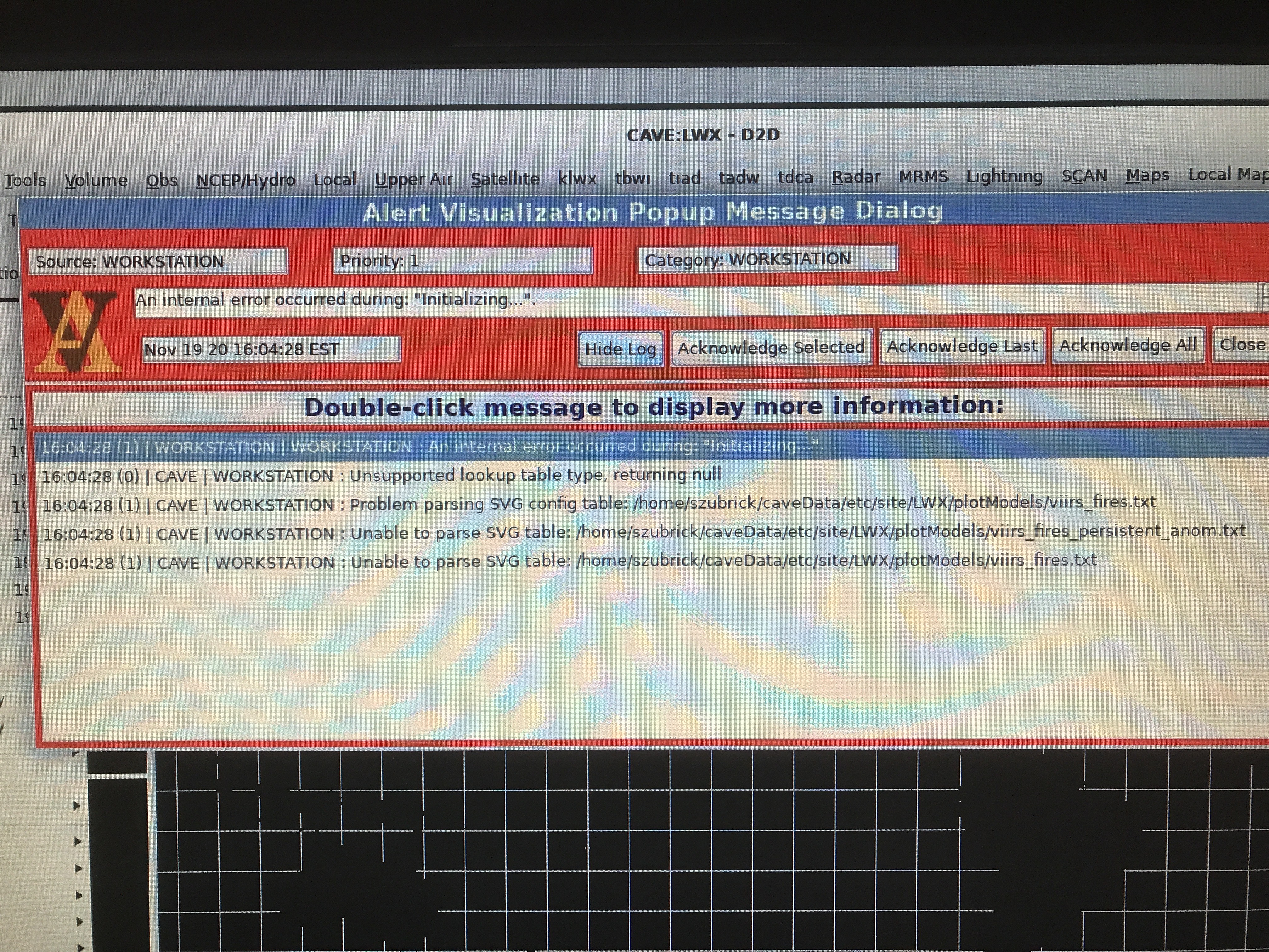
10. (Nov 2020). After installing version the towr-s RPM, the first time launching cave to select the VIIRS Fires product, yields a red alertviz banner regarding viirs fires txt and/or and SVG config table. Explanation/Suggestion: This may occur the first time the graphics svg/txt file are invoked at a user (non-base) level but did not exist before at the base level. Restart CAVE and this message will/should not return or have any impact. This error will/should not return unless ~/caveData is cleared. If the latter it may repeat the first time CAVE is launched. The banner may look like this:
11. (Dec 2020) A CWSU was not seeing the updated changes installed by the TOWR-S RPM, for their system which runs off of px1. The solution was to remove caveData and re-start CAVE. From a terminal window, type rm -rf ~/caveData. Then restart CAVE.
12. (Dec 2020). The GOES GLM, GOES Ice, and/or GOES Turbulence products are arriving to my LDM and storing under /data_store/goes-r but they are not decoding or displaying in AWIPS (no green times). Solution: There may be missing patterns in the goesr plugin distribution file owing to Data Add-ons Manager upgrades made prior to December 9, 2020 (future towr-s RPM and DAM updates will sync up the configurations for goesr products). Make sure all of the necessary patterns are included in your goesr xml distribution file. Those patterns are linked here in the DAM repository and also provided at this link. The entries specific to towr-s RPM v20 are "GOES ice conc and thickness" (rows 11-12), "GLM Full Disk Tiles" (rows 20-21), and "GOES turbulence from CIMSS.." (rows 22-23). Details are also provided in Step I of the towr-s RPM installation instructions (see *Notes prior to install). After any modification to goesr.xml, save the file and then remove /awips2/edex/data/utility/common_static/site/your_site_name/distribution/goesr.xml.md5. An edex bounce is not required for the new patterns to be picked up by edex.
13. (Jan 7, 2021). Some CWSUs report not being able to see the new towr-s v20 menu items after the host site has updated the configurations. Action (provided by Lance Bucklew of SR): The host site can make sure the data is populating to /usr/local/ldm/ldmd.log file on cpsbn1. Consider a service ldmcp stop and service ldmcp start as root if the data is ingesting from ls1 via a notifyme command but not saving. Then, back up each user's caveData dir on the ARD, then remove them and restart CAVE. The ARD for the CWSU should then show the menus.
14. (Feb 1, 2021). The Full Disk GLM is not covering most of the Southern Hemisphere. Response: This is expected and due to the data flow. Tiles which make up a full disk GLM scene are being filtered upstream at the regional LDM to save on bandwidth. Not all GLM data for the GOES full disk is being sent. If your site requires extended GLM coverage beyond what is provided, please contact your regional focal point.
15. (Jun 4, 2021). The Satellite menu appears abbreviated compared to what the v21 check-out procedure shows (for example, it includes no Conus GOES-East/West Visible, IR, WV buttons, and or No Full Disk GLM). This may be due to a site or user over-ride. Check this pdf link or this pptx link for more information and procedures for making all items appear under Satellite.
16. (Feb 8, 2022). The GOES Band 13 (10.35 um IR) product which displays at Degrees F has a style rule issue in Version 22. The product displays and samples correctly, but the legend reads:

Instead, the legend should read:

The issue occurred when we updated some configurations that include the sector (e.g. WCONUS) in the imagery products. This will be fixed in future towr-s RPM releases (and the baseline submission). To fix the legend, do the following (requires site edit privileges for the CAVE styleRules file):
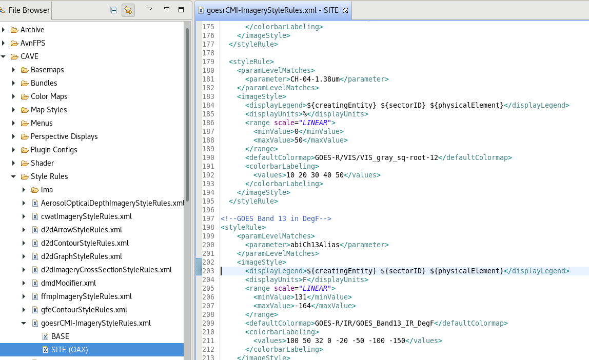
The Localization view above shows the styleRules file that controls the Band 13 degF imagery product. It is opened by going to CAVE, Style Rules, then open the SITE version of goesrCMI-ImageryStyleRules.xml. Go to line 203. Replace the string ${physicalElement} with "CH-13-10.35um DegF". See below to see the changed string on line 203:
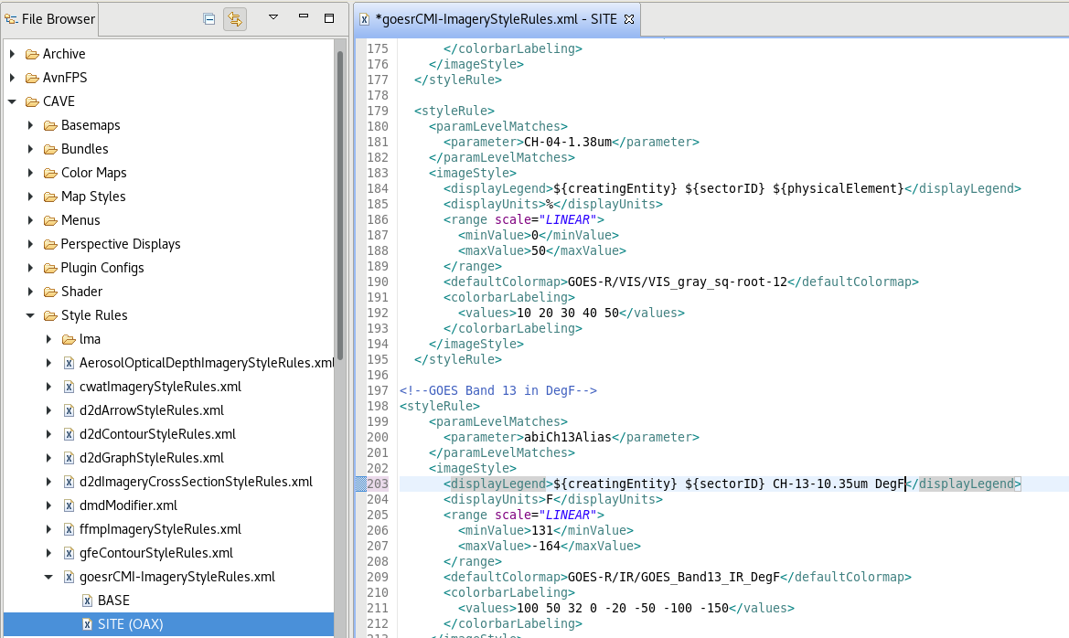
Notice, above, that line 203 is updated (having added "CH-13-10.35um DegF"). Save the file and close. restart CAVE and the legend should read distinctly as shown above.
17. (Mar 7, 2022). New I-Band-based VIIRS Active Fires products are now flowing into AWIPS. These are available under Satellite -> S-NPP and NOAA-20 -> Derived Products, as before. A change in the the cursor sampling of the Fire Confidence results from this data source upgrade. Confidence appears now as either 7, 8, or 9%. Rather than percent confidence, these numbers refer to a categorical confidence. 7 equates to Low, 8 equates to Nominal and 9 equates to High confidence. See this presentation for additional details on the change.