


Survey/Blog - Geostationary Lightning Mapper
Forecaster Survey
Forecasters are encouraged to complete the survey below or within google forms (https://forms.gle/v7jPobc9SMfKMbC39)
Blog Post Entry
Forecasters are invited to submit blog posts using either the "+Add Blog Entry" button below or a simplified google submission form available here (https://forms.gle/6wpcHdrfGrwBx91G9)
GLM Blog Posts
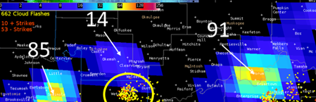
There appeared to be a good case of optical extinction with a severe warned storm near the Hughes/McIntosh county line in southeast Oklahoma on 10...
Because the GLM is an optical detector and looks for changes in brightness over a certain time interval, there will be times that sun glint off of various objects will result in a false detection. For the most part, the processing algorithms will filter out false detections but every once in a while something will make it through. 99% of the time, this won't impact operations but...
As great as is to use data from the Geostationary Lightning Mapper, there is an important caveat forecasters have to consider when using the data. During the afternoon of July 11, typical “air mass” showers and thunderstorms were developing across northern Alabama, including several south of the Huntsville International Airport. At 12:18 PM CDT, the GLM Flash Extent Density data...
On 19 July 2018 a lone, left-moving supercell was observed with GLM moving from eastern Kansas into western Missouri. The loop below has 1-min GLM Flash Extent Density with IR (UL), 1-min Average Flash Area with Visible (UR), 1-min Total Optical Energy (LL) and regional radar reflectivity (LR) at 5-min intervals. This event was captured to document observed lightning...
While monitoring GLM across the central Great Plains on 19 Jun 2018 it was noted that several storm clusters showed single, small, dim flashes along their trailing edges. These features would come and go over time and seemed highly out of place being so far removed from the strongest updrafts. The flashes appeared to be well into the anvil region and at a greater distance from the...
For the seventh consecutive year, NWS Huntsville provided on-site weather support for a large outdoor country music concert in Cullman, Alabama this past weekend. This concert is usually held in June, one of the most problematic times of year for forecasting due to the seemingly-random nature of summertime convection. Public safety officials have had to stop the concert once for the threat of...
As part of our impact weather responsibilities, NWS Huntsville issues Airport Weather Warnings (AWWs) for Huntsville International Airport (KHSV) and Northwest Alabama Regional Airport (Muscle Shoals; KMSL). AWWs are issued for the threat to personnel working outside at the terminal and neighboring operations, not for the threat to aviation as a whole. One of our criteria for AWW...
During the evening hours of June 27th, we noticed that GLM average flash area data was indicating a substantial flash from the main core of storms over northeast AL/northwest GA towards middle TN. This occurred around June 28th, 0130Z-0140Z, and I have included both a screen shot and animation for this flash. Though no DSS events were scheduled over this particular area, it would...
Some of our forecasters aren't crazy about the color tables for the GLM lightning products. Are there additional color tables available for them to try or are they forced to make their own?
Test post about GLM detection of initial electrical activity to see if VLab can post within AWIPS.
The HWT forecasters noted enhanced lightning activity in both merging and splitting convective cells. This trend is important for forecasters to be aware of, especially in the interest of issuing timely warnings and monitoring the intensity of discrete storms.
High-density, bright, and/or small flashes tend to be collocated with convection and strong updrafts. The color maps in the GLM gridded products effectively draw forecaster attention to areas with the most intense convection in broad-coverage systems. In these cases, the gridded products complement IR and radar well, providing a clearer picture on the situation, especially with warning operations.
One of the most often-used GLM applications is tracking convective evolution. The GLM has a high-resolution temporal scale, which allowed HWT forecasters to closely monitor the storm strength. It was also noted that spikes in GLM gridded products were collocated with rapid intensification. These trends would aid forecasters in warning operations and overall environmental awareness.
GLM gridded products (especially Average Flash Area) captured the areal extent of lightning better than ground-based lightning detection networks. According to HWT forecasters, this information would be invaluable to warning-issuance operations, public outreach regarding the dangers of lightning, and debriefings with emergency personnel.
In several cases, forecasters at the HWT noted that the GLM showed the initial flashes. These flashes often had several minutes of lead time on both of the ground-based lightning detection networks and IR cloud top cooling signatures, which would ultimately allow forecasters in nowcasting situations to pinpoint areas of convective development with additional lead time.
The viewing angle influences the depiction of GLM observations but is straightforward to account for with the proper knowledge of GLM detection capabilities. This line of severe storms in the upper Great Plains illustrates several important aspects of the GLM observations. The earliest frames illustrate the side-cloud illumination that can result from the steep viewing angle... ...