Forecasters who participated in the Hazardous Weather Testbed (HWT) Spring 2018 Experiment provided useful feedback on GLM gridded products as they tracked numerous convective systems over the four-week period. Alongside imagery of the data, they provided use cases of the GLM in several forecasting situations, suggested interesting trends, and provided potential applications of the gridded products. The following imagery and quotes taken from their blog posts on the HWT page illustrate their situation-based findings.
Please note that given the experimental nature of the data, some imagery may contain GLM products that will not be included in AWIPS. Additionally, data visualization (e.g. colormaps and scales) was (and still is) undergoing changes, so variability in imagery throughout the posts and in final NWS implementation is inevitable.
One of the most common and useful forecasting applications of GLM gridded products is tracking the lifecycle of convective storms. Forecasters at the HWT found the gridded products useful in terms of diagnosing the both the development and the decay of convective storms during ongoing severe events. The products also helped them pinpoint storms that were quickly becoming severe, which aided their decisions during warning operations.
One forecaster noted using all three gridded GLM products to track rapid storm development:
“Of particular interest is the rapid increase in GLM flash extent density collocated with smaller average flash area and high total energy with a quickly-developing and strengthening updraft. The increase in flash event density also aided in the decision to put out a warning for the storm…” –Rosie Red
Another forecaster utilized the same four-panel view to help with his warning decision-making process:
“GLM was my primary tool used in deciding to issue a warning based on an increasing trend I began to notice around 2230Z. between 2230 & 2250 Flash density increased from 10 to 30 & total energy from 50 to over 100... At the same time I noticed a cooling trend on cloud tops on the GOES 16 clean window IR which added even more confidence to the lightning data that this storm would continue to intensify.” –Peter Sunday

Here, the three GLM gridded products were used both to track rapid development and identify where thunderstorms were best maintaining their intensity:
“Tracking northern NE storms, we could see the GLM spikes on rapidly strengthening thunderstorms across Sheridan and Cherry counties in north-central part of the state. These storms are exhibiting strong hail and wind signals…Interestingly enough, while the initial spikes were impressive, the storms further south and west (south of the warm front) seem to have a higher GLM total energy and density overall and for a longer duration.” –Jack Swigert
GLM gridded products (namely TOE and FED) were used to monitor convective strength of thunderstorms during a long-lasting severe event:
“In this example the storm is on the northern RAH CWA border, the updraft has pushed 50-60dbz echoes up through the -20 C isotherm, notice this time the GLM Total Energy and the Extent Density (# of Flashes that have crossed a pixel) are both showing high values. This would be a good situation awareness tool during an ongoing severe weather event. This storm was currently producing damaging hail and strong winds.” – Tom Clemmons
 Signatures on the gridded GLM products (especially TOE) helped another forecaster issue warnings on rapidly-intensifying thunderstorms (note that the Flash Event Density in the top left panel that the author refers to will not be implemented in AWIPS):
“We issued four severe warnings for northern Indiana and southern Michigan. All storms displayed good dual pol signatures, but we also noticed a sharp uptick in GLM Total Energy and Event Density on the storms we issued for. This increased our overall confidence in warning issuance.” – Jack Swigert
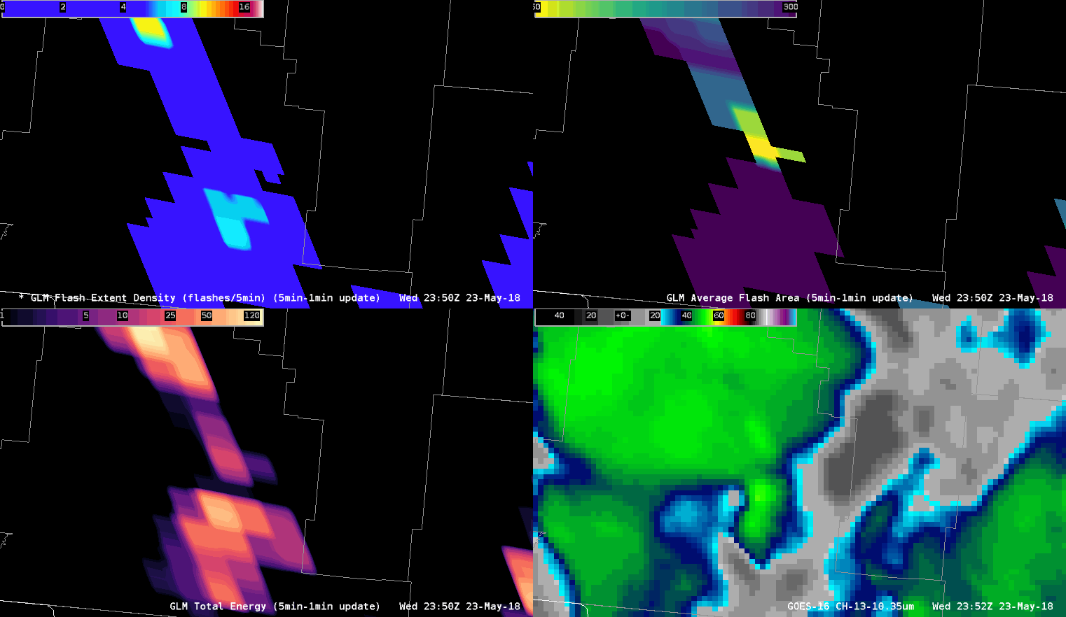
This final example reiterates the thoughts of previous posts; GLM TOE spikes with thunderstorm intensification, and AFA helps portray the overall convective scene (note that the Flash Event Density in the top left panel that the author refers to will not be implemented in AWIPS):
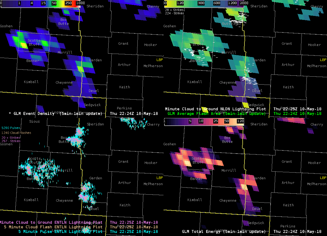
“Noticed a marked increase in Flash Density, Total Energy, and Average Flash Area as the storm strengthened over Garden County Nebraska... Included an animation of the GLM data along with ENTLN and NLDN to calibrate my thinking a bit. On the average flash area notice the large flash stretching across Cheyenne and Deuel counties in Nebraska.” – “Supercell”