


QLCS Snow Squall Conceptual Model - Snow Squalls and Snow Squall Warnings
QLCS Snow Squall Conceptual Model
OVERVIEW
Snow squalls are a type of mesoscale convective system producing heavy snow and gusty winds. The most intense and long-lived snow squalls take the form of a quasi-linear convective system (QLCS) near cold/arctic fronts. This conceptual model is based on the QLCS type only. Note: other convective modes (cells, clusters) may also warrant Snow Squall Warnings (SQWs), especially when accompanied by a potential flash freeze.
ANATOMY OF A QLCS SNOW SQUALL
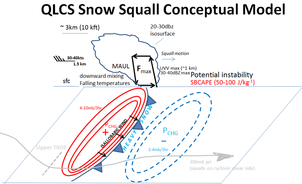
Here are some key things to look for when forecasting the potential for linearly organized snow squalls along cold fronts. The squalls are located on the cyclonic shear side of the 300-mb jet, and may have upper-level support in the form of a mid-upper level shortwave trough. At the surface, you’ll notice a strong pressure rise/fall couplet on either side of the surface front. Typically, pressure rises will be on the order of 5 to 10 mb over 3hrs in the wake of the boundary. The isallobaric wind is directed from the area of pressure rises behind the front, toward the area of pressure falls in advance of the front. This becomes important for enhancing wind gusts within the zone of frontogenetic forcing, seen at the top of the diagram.
The frontogenetic circulation is typically the main driver of the vertical motion associated with the squalls. The frontogenetic circulation is thermally direct, meaning we have rising motion on the warm side of the boundary, and sinking motion on the cold side. Typically the vertical motion maximum will be located ~1 km AGL, with a max of 30-40 dBZ values within this area of the snow squall, and often 20-30 dBZ echoes extending upward to 10-15 kft. As the front moves downstream – from left to right in this diagram - it typically acts upon small amounts of SBCAPE, typically only on the order of 50-100 J/kg, contributing to the convective nature of these events. The strong mesoscale forcing makes up for the absence of much instability in most cases. In the descending branch of the frontogenetic circulation, there is typically a moist absolute unstable layer, or MAUL, where there is strong turbulent motion and efficient downward mixing of strong winds. There is typically low-level cold air advection with falling temperatures and steep lapse rates, which also creates a favorable environment for downward mixing and strong surface wind gusts. For these reasons, the strongest surface gusts are located just behind the cold front.
Background flow is perpendicular to the front and typically strong, 30-40 kts at 850mb (1-2km AGL), and contributes to quick translation of the snow squall. Added to system propagation with the pressure rise-fall couplet, forward motion of the convective system can exceed 40kts in some cases.
NAM3km Cross-Section Example
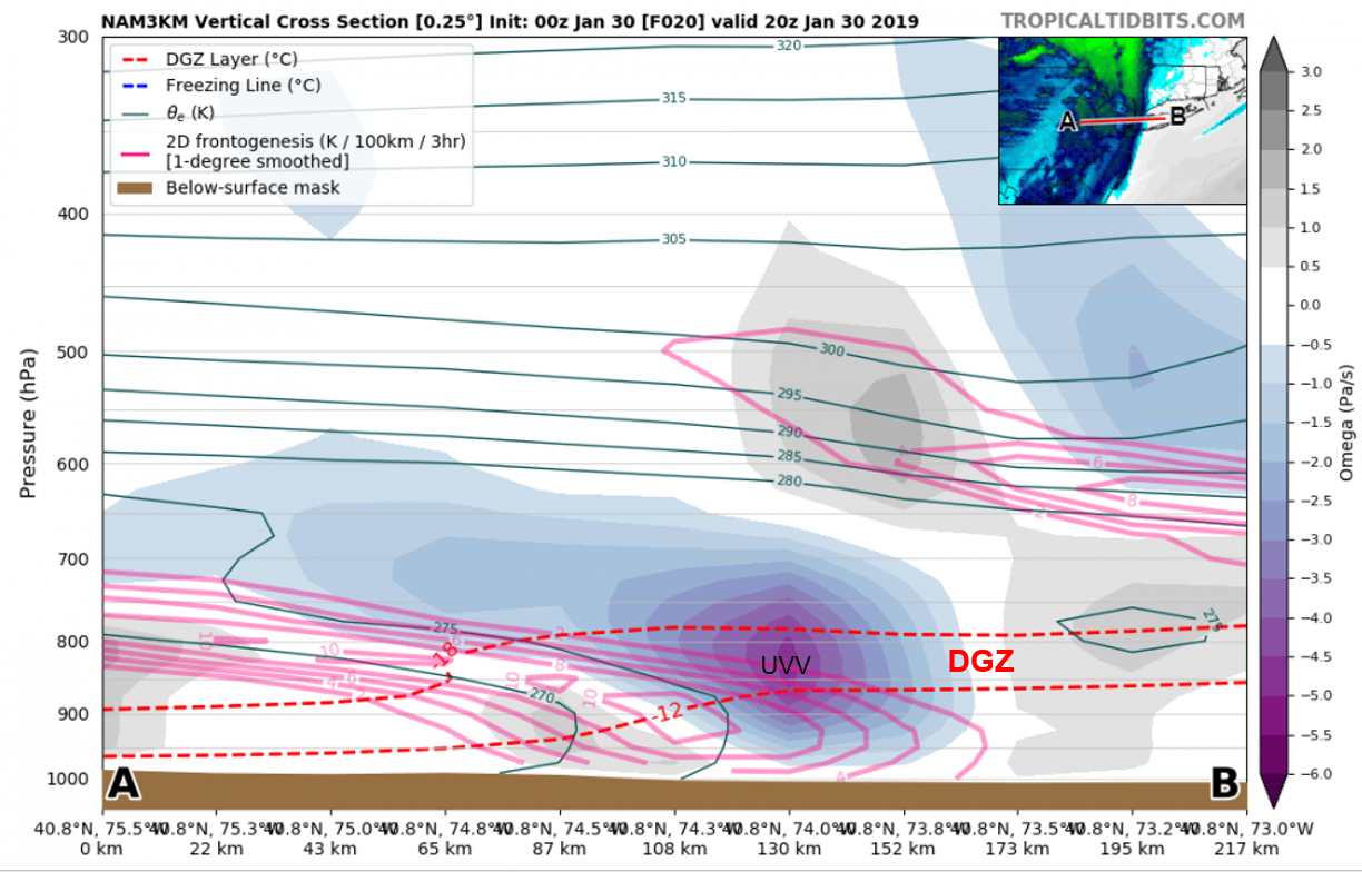
The sloped frontogenetic maximum is evident in this cross-section along the leading edge of the cold front (leading edge of lower theta-e). The theta-e surfaces are "folded" near the ground in the center of the cross-section, suggesting potential instability is present in the frontal zone. Neutral stability is present in advance of the front. Note that the upward vertical velocity (UVV) max near 850mb is coincident with the dendrite growth zone (-12C to -18C), which maximizes microphysical efficiency. The descending branch of the frontogenetic circulation is weaker, but evident west of the sloped frontogenetic maximum near 925mb.