


VIL Density - Warning Decision Training Division (WDTD)
Navigation Links
Products Guide
VIL Density
Short Description
Vertically Integrated Liquid (VIL) divided by the depth of the column
Subproducts
None
Primary Users
NWS WFO
Input Sources
Vertically Integrated Liquid (VIL)
Resolution
Spatial Resolution: 0.01o Latitude (~1.11 km) x 0.01o Longitude (~1.01 km at 25oN and 0.73 km at 49oN)
Temporal Resolution: 2 minutes
Product Creation
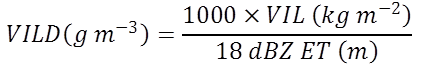
At each 2D horizontal grid point, the VILD is computed by dividing the VIL value by the height of the 18 dBZ Echo Top (ET) using (Amburn and Wolf 1997):
Technical Details
Latest Update: MRMS Version 11.5
References
Amburn, S. A., and P. L. Wolf, 1997: VIL density as a hail indicator. Wea. Forecasting, 12, 473-478.
Greene, D.R., and R.A. Clark, 1972: Vertically integrated liquid water-A new analysis tool. Mon. Wea. Rev., 100, 548-552.
Troutman, T. W. and M. Rose, 1997: An examination of VIL and echo top associated with large hail in Middle Tennessee. NWS Southern Region Technical Attachment SR/SSD 97-15. Fort Worth, TX.
Applications
Sometimes still used to assess storms for their severe potential, particularly during the cool season.
Example Images
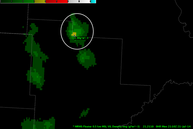
Fig. 1: Vertically Integrated Liquid Density (VILD) for a short-lived severe thunderstorm (within white
circle) over North Dakota on 21 July 2014 at 2110Z. SPC storm reports indicate 1.75-in hail was
reported near the location of the cursor at approximately this time.