


Vertically Integrated Liquid (VIL) - Warning Decision Training Division (WDTD)
Navigation Links
Products Guide
Vertically Integrated Liquid (VIL)
Short Description
Radar-derived estimate of liquid water in a vertical column.
Subproducts
None
Primary Users
NWS WFO
Input Sources
3D Reflectivity Cube
Resolution
Spatial Resolution: 0.01o Latitude (~1.11 km) x 0.01o Longitude (~1.01 km at 25oN and 0.73 km at 49oN)
Temporal Resolution: 2 minutes
Product Creation
The conversion of weather radar reflectivity data into liquid water content is based on theoretical studies of dropsize distributions and empirical studies on the relationship between reflectivity factor and liquid water content (Greene and Clark 1972).
VIL is a radar-derived estimate of liquid water (exclusive of ice) that is computed at each grid point from the vertical profile of reflectivity using the following equation (Greene and Clark 1972):
 ,
,
where, Z is the radar reflectivity and h is the height expressed in meters. To exclude contributions from ice, if  , that term is set to 56 dBZ.
Technical Details
Latest Update: MRMS Version 11.5
References
Amburn, S. A., and P. L. Wolf, 1997: VIL density as a hail indicator. Wea. Forecasting, 12, 473-478.
Greene, D.R., and R.A. Clark, 1972: Vertically integrated liquid water–A new analysis tool. Mon. Wea. Rev., 100, 548-552.
Applications
Can be used to triage (quickly rank) storms based on their severe potential.
Sometimes still used to assess storms for their severe potential, particularly in a pulse severe environment.
Example Images
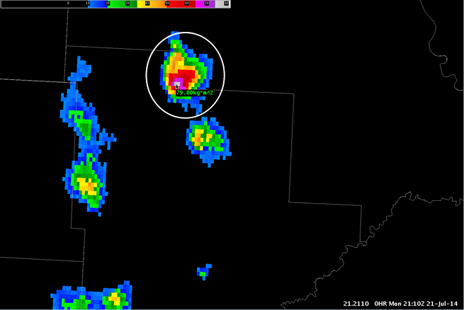
Fig. 1: Vertically Integrated Liquid (VIL) for a short-lived severe thunderstorm (within white circle) over
North Dakota on 21 July 2014 at 2110Z. SPC storm reports indicate 1.75-in hail was reported near the
location of the cursor at approximately this time.