


xx dBZ Echo Top (ET) - Warning Decision Training Division (WDTD)
Navigation Links
Products Guide
xx dBZ Echo Top (ET)
Short Description
The maximum altitude for a particular reflectivity value (e.g., 18 dBZ) within a vertical column.
Subproducts
18 dBZ ET
30 dBZ ET
50 dBZ ET
60 dBZ ET
Primary Users
NWS: WFO, SPC, CWSU, AWC
FAA: ARTCC, ATCSCC
Input Sources
3D Reflectivity Cube
Resolution
Spatial Resolution: 0.01o Latitude (~1.11 km) x 0.01o Longitude (~1.01 km at 25oN and 0.73 km at 49oN)
Temporal Resolution: 2 minutes
Product Creation
At each horizontal 2D grid point, the reflectivity values at the vertical grid points are checked from the top-down. Once the ET threshold value for the particular sub-product is equaled or exceeded, that altitude and the altitude at the next-highest grid point are used to compute the ET value using linear interpolation based on the slope of the reflectivity value between those two altitudes.
Technical Details
Latest Update: MRMS Version 11.5
References
Elliott, M., 2013: Electrical discharges in the overshooting tops of thunderstorms. M. S. Thesis, School of Meteorology, University of Oklahoma, 139 pp.
Lakshmanan, V., A. Fritz, T. Smith, K. Hondl, and G. J. Stumpf, 2007: An automated technique to quality control radar reflectivity data. J. Appl. Meteor., 46, 288-305.
Lakshmanan, V., K. Hondl, C. K. Potvin, and D. Preignitz, 2013: An improved method for estimating radar echo-top height. Wea. Forecasting, 28, 481-488.
Maddox, R. A., D. S. Zaras, P. L. MacKeen, J. J. Gourley, R. Rabin, and K. W. Howard, 1999: Echo height measurements with the WSR-88D: Use of data from one versus two radars. Wea. Forecasting, 14, 455-460.
Strengths
Like all MRMS products, the use of multiple radars is more robust than single-site radar alone. It provides faster updates and helps the forecaster integrate data from multiple radars. It also compensates for cone-of-silence, beam broadening at far ranges, and terrain blockage.
The use of multiple radars helps to reduce the “stair-step” pattern (Fig. 1) that is observed in single-radar ET products (Figs. 2 and 3).
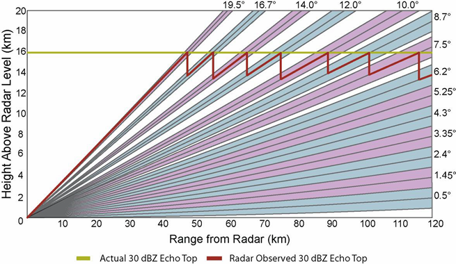
Fig. 1: Plot of WSR-88D radar beam height as a function of range. The alternating blue and purple
colors illustrate the different elevation angles (VCP 11 shown here). For each elevation angle, the
center black line indicates the center line of the radar beam, while the upper and lower black lines
indicate the top and bottom of the beam, respectively. A hypothetical 30 dBZ ET at 16 km (yellow line)
is overlain alongside the radar-observed 30 dBZ ET (red line) to illustrate the “stair-step” pattern in
ETs observed by single-site radars. Adapted from Elliott 2013.
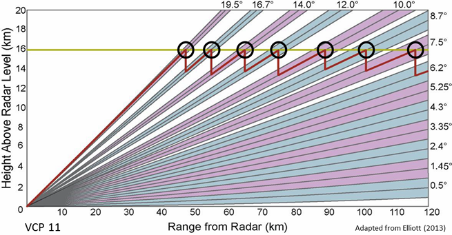
Fig. 2: Same as in Fig. 1, except the locations where the radar-observed 30 dBZ Echo Top equals the
"true" 30 dBZ Echo Top are circled.
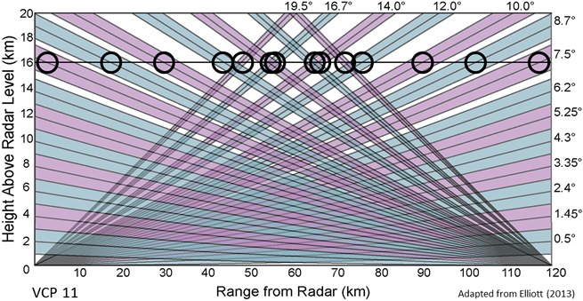
Fig. 3: Same as in Fig. 2, except another radar has been added at 120 km to illustrate the impact of
adding multiple radars. The locations where the multiple-radar-observed 30 dBZ Echo Top equals the
"true" 30 dBZ Echo Top are circled.
Limitations
The “stair-step” appearance of ET data may not be completely alleviated, especially for stratiform echoes and those areas only sampled by one radar.
Quality Control
These products are derived from the 3D Reflectivity Cube, which means non-hydrometeorological data has been removed including: Ground clutter, anomalous propagation (AP), chaff, interference spikes, and bioscatterers (e.g., angels and ghosts).
Applications
All Echo Top products:
- Can be used to assess updraft intensity trends. Height rises (falls) in ETs often indicate a strengthening (weakening) updraft.
- Can be used to identify overshooting tops when ET heights are above the equilibrium level.
- Useful for tactical and short-term strategic decisions about air traffic routing.
18 dBZ ET
- Corresponds to the WSR-88D Enhanced Echo Tops (EET) product.
- Approximate height of the cloud top.
30 dBZ ET
- Roughly corresponds to the Storm Top, which is used in the WSR-88D Storm-Cell Identification and Tracking (SCIT) algorithm. However, the 30 dBZ ET uses a mean sea level (MSL) reference, while WSR-88D Storm Top uses an above radar level (ARL) reference.
- Approximate height of the storm top.
50 dBZ ET
- Can be used to assess storm severity including hail potential.
60 dBZ ET
- Can be used to assess storm severity including hail potential.
Example Images

Fig. 4: 18, 30, 50, and 60 dBZ Echo Tops (ETs) for a supercell thunderstorm over Iowa at 1852 UTC on
20 June 2014. This storm had a vigorous updraft with 60 dBZ ETs near 45 kft (MSL). SPC storm reports
indicate 2.75 inch hail was reported near the location of the highest ETs at approximately this time.