


Surface Precipitation Type (SPT) - Warning Decision Training Division (WDTD)
Navigation Links
Products Guide
Surface Precipitation Type (SPT)
Short Description
Algorithm which classifies radar echoes into one of seven categories: 1) warm stratiform rain, 2) cool stratiform rain, 3) convective rain, 4) tropical/stratiform rain mix, 5) tropical/convective rain mix, 6) hail, and 7) snow. The primary use of the SPT is for automatic selection of Z-R relationships and for computing Surface Precipitation Rates (SPRs) from the Seamless Hybrid Scan Reflectivity (SHSR) mosaic.
Subproducts
None.
Primary Users
NWS: WFO, RFC
Input Sources
NOAA/NCEP Rapid Refresh (RAP) with nested High-Resolution Rapid Refresh (HRRR) surface temperature and wet-bulb temperature, RAP with nested HRRR Freezing Level Height; severe weather products such as Reflectivity at -10°C, Vertically Integrated Liquid (VIL), Maximum Estimated Size of Hail (MESH); and MRMS/Q3 products such as Tilt Apparent Vertical Profile of Reflectivity (Tilt AVPR), Seamless Hybrid Scan Reflectivity (SHSR), and Probability of Warm Rain (POWR)
Resolution
Spatial resolution: 1km x 1km
Temporal resolution: 2 minutes
Product Creation
The algorithm begins by determining the presence of precipitation, using the Seamless Hybrid Scan Reflectivity (SHSR). If there is precipitation occurring, it then delineates frozen precipitation. It uses the RAP temperatures to label “snow”, and the Maximum Estimated Size of Hail (MESH) to label “hail”. If none of these criteria are met, the precipitation is assumed to be liquid. The cell is classified as either convective or stratiform, using the Convective/Stratiform Precipitation Separation (CSPS) algorithm. If convective, reflectivity of surrounding cells is checked and “convective rain” is delineated. Stratiform rain is sub-divided into “warm stratiform” and “cool stratiform”, based on RAP Surface Temperature. Finally, each of these three liquid classifications is checked for tropical characteristics, using the Tropical Rain delineation process. If the “tropical” criteria are not met, then the cell retains its initial classification.
Technical Details
Latest Update: MRMS Version 12.2 (see this document for the latest updates to the SPT algorithm)
Accessible on: MRMS Operational Product Viewer (under "Precip flag/bright band")
Figure 1 is a schematic of the Surface Precipitation Type classification process. The first step is to determine whether there is any precipitation occurring. The Seamless Hybrid Scan Reflectivity (SHSR) is used for this decision. If SHSR < 5dBZ, then the grid cell is given a label of “no precipitation”, and the process is complete. In the cold season, there is no cutoff (as opposed to 5 dBZ) because the Dual-Pol Quality Control is better at eliminating non-precipitation signatures, and thus, lighter precipitation signatures can be depicted with less concern about introducing contamination that can be interpreted as rain (e.g. blooms).
For any echoes greater than 5dBZ, precipitation is assumed to be occurring, and further variables are checked to decide the type. The algorithm begins by checking for frozen precipitation. First, it uses thresholds of surface temperature and wet-bulb temperature to determine the label of “snow”. Next, it will classify the cell as “hail” if the Maximum Estimated Size of Hail (MESH) exceeds 0mm.
If none of these criteria are met, then the cell is considered to be liquid precipitation and subject to one of five possible classifications. At this point, the cell must first be defined as either convective or stratiform in nature. This is done using the Convective/Stratiform Precipitation Separation algorithm (CSPS), which incorporates information about the freezing level height, Vertically Integrated Liquid (VIL), and Reflectivity at -10°C. These criteria help reduce false identification in bright band areas (Qi et al., 2013a). Once a cell is deemed a convective core, the reflectivity of surrounding cells is considered to delineate all “convective rain” areas.
Stratiform rain is further sub-divided into warm or cool based on the surface temperature exceeding 5°C. Once these three initial classifications are made, each is checked to see if it can be further sub-divided into a tropical type. The Tropical Rain delineation process is used to define tropical/convective or tropical/stratiform rain. If the criteria for a tropical type are not met, then the cell maintains its initial classification of warm stratiform, cool stratiform or convective rain.
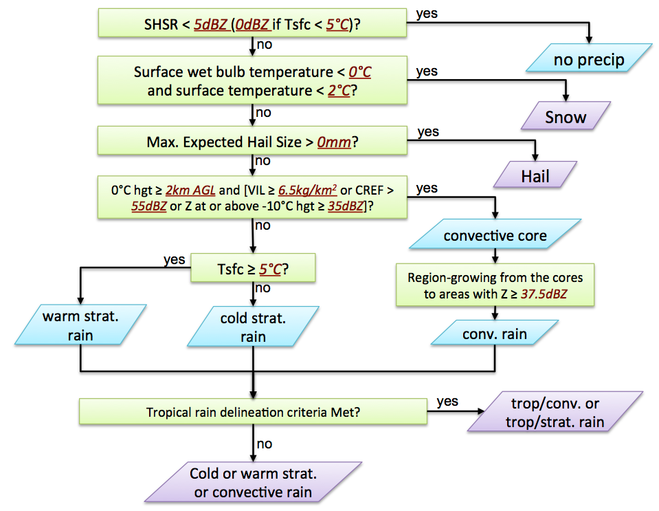
Figure 1. Schematic of the surface precipitation type classification process in the MRMS. (Image from Zhang et al. 2014)
References
Qi, Youcun, Jian Zhang, and Pengfei Zhang. "A real‐time automated convective and stratiform precipitation segregation algorithm in native radar coordinates." Quarterly Journal of the Royal Meteorological Society 139.677 (2013): 2233-2240.
Zhang, J., K. Howard, S. Vasiloff, C. Langston, B. Kaney, Y. Qi, L. Tang, H. Grams, D. Kitzmiller, J. Levit, 2014: Initial Operating Capabilities of Quantitative Precipitation Estimation in the Multi-Radar Multi-Sensor System. 28th Conf. on Hydrology, Amer. Meteor. Soc.
Zhang, Jian, et al. "National Mosaic and Multi-Sensor QPE (NMQ) system: Description, results, and future plans." Bulletin of the American Meteorological Society 92.10 (2011): 1321-1338.
Convective/Stratiform Precipitation Separation documentation
Tropical Rain Identification documentation
Other MRMS product documentation: Seamless Hybrid Scan Reflectivity, Probability Of Warm Rain
Applications
Automatic selection of Z-R relationships, for computing Surface Precipitation Rates (SPRs) from the Seamless Hybrid Scan Reflectivity (SHSR) mosaic.
Example Images
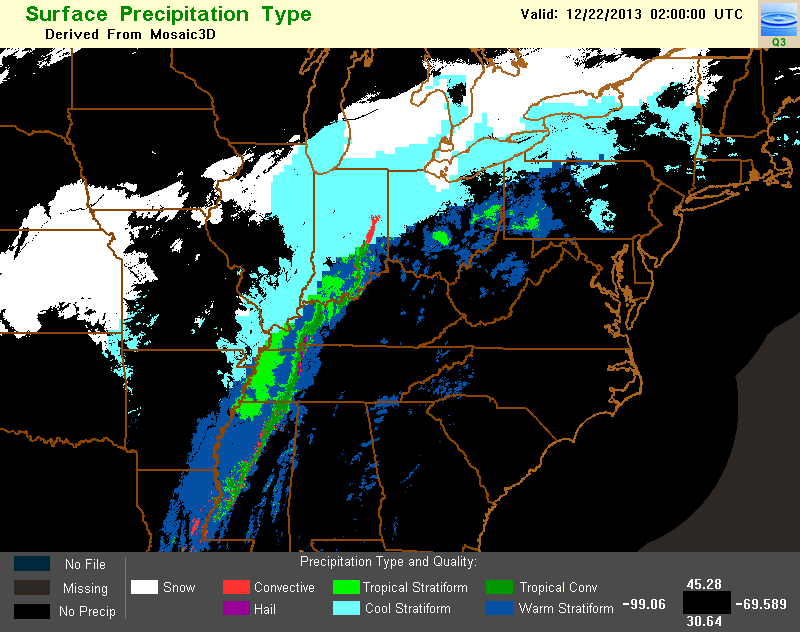
Figure 2. Example image of the Surface Precipitation Type product, valid at 02Z on December 22, 2013.