WSR-88D Constant Altitude Reflectivity Mosaic - Warning Decision Training Division (WDTD)
Navigation Links
- 2D Reflectivity Mosaics
- 3D Derived Reflectivity Mosaics
- 3D Reflectivity Mosaics
- FLASH Products
- Lightning
- Most Useful Products
- Operational MRMS Hydro Products
- Precipitation Quality Control
- Severe Weather
- Reflectivity At Lowest Altitude (RALA)
- Reflectivity at x°C
- Probability of Severe Hail (POSH)
- Severe Hail Index (SHI)
- Vertically Integrated Liquid (VIL)
- VIL Density
- xx dBZ Echo Top (ET)
- MESH Tracks
- Rotation Tracks
- Maximum Estimated Size of Hail (MESH)
- Vertically Integrated Ice (VII)
- Height of xx dBZ Echo Above x°C
- Azimuthal Shear
- ProbSevere
- Supplementary MRMS Hydro Products (not on AWIPS)
- Useful Products for Aviation
- Composite Reflectivity Track 60min
- Layer Composite Reflectivity
- Composite Reflectivity
- Composite Reflectivity Height
- Lightning Probability
- Lightning Density
- MESH Tracks
- Maximum Estimated Size of Hail (MESH)
- Rotation Tracks
- Azimuthal Shear
- VIL Density
- xx dBZ Echo Top (ET)
- Vertically Integrated Ice (VII)
- Vertically Integrated Liquid (VIL)
Products Guide
WSR-88D Constant Altitude Reflectivity Mosaic
Short Description
The reflectivity at a constant altitude above mean sea level (MSL)
Subproducts
Continental Constant Altitude Reflectivity Mosiac (MSL)
- 0.50 km, 00.75 km
- 1.00 km, 1.25 km, 1.50 km, 1.75 km
- 2.00 km, 2.25 km, 2.50 km, 2.75 km
- 3.00 km, 3.25 km, 3.50 km, 3.75 km
- 4.00 km, 4.50 km
- 5.00 km, 5.50 km
- 6.00 km, 6.50 km
- 7.00 km, 7.50 km
- 8.00 km, 8.5 km
- 9.00 km
- 10.00 km
- 11.00 km
- 12.00 km
- 13.00 km
- 14.00 km
- 15.00 km
- 16.00 km
- 17.00 km
- 18.00 km
- 19.00 km
Primary Users
NWS WFO
Input Sources
3D Reflectivity Cube, with only WSR-88D data.
Resolution
Spatial Resolution: 0.01o Latitude (~1.11 km) x 0.01o Longitude (~1.01 km at 25oN and 0.73 km at 49oN)
Temporal Resolution: 2 minutes
Product Creation
At each horizontal 2D grid point, the reflectivity at the specified altitude is determined.
Technical Details
Latest Update: MRMS Version 10
References
Lakshmanan, V., and T. W. Humphrey, 2014: A MapReduce technique to mosaic continental-scale weather radar data in real-time. IEEE J. of Select Topics in Appl. Earth Obs. and Remote Sensing, 7.
Lakshmanan, V., T. Smith, K. Hondl, G. J. Stumpf, and A. Witt, 2006: A real-time, three dimensional, rapidly updating, heterogeneous radar merger technique for reflectivity, velocity and derived products. Wea. Forecasting, 21, 802-823.
Strengths
Like all MRMS products, the use of multiple radars is more robust than single-site radar alone. It provides faster updates and helps the forecaster integrate data from multiple radars. It also compensates for cone-of-silence, beam broadening at far ranges, and terrain blockage.
Limitations
Bright band contamination is not removed.
The temperature at the specified height is not identified.
Only uses WSR-88D radar data. The Continental Constant Altitude Reflectivity Mosaic includes other radars including Canadian.
Quality Control
This product is derived from the 3D Reflectivity Cube, which means non-hydrometeorological data has been removed including: Ground clutter, anomalous propagation (AP), chaff, interference spikes, and bioscatterers (e.g., angels and ghosts). However, bright band contamination (i.e., anomalously-high reflectivity caused by melting snowflakes) remains.
Applications
Allows forecaster to quickly interrogate storms at particular altitudes (e.g., hail growth zone, dendritic growth zone, etc.).
Example Images
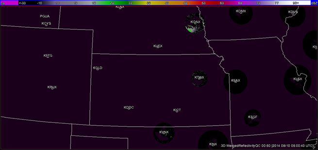
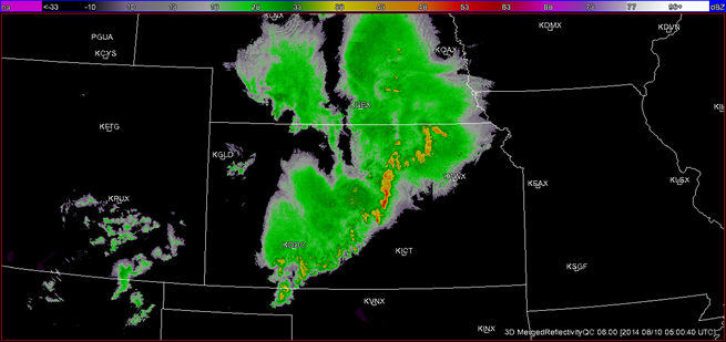
Fig. 1: WSR-88D Constant Altitude Reflectivity Mosaic at 0.5 km for a MCS over Kansas at 0500 UTC
on 10 August 2014. Note the poor radar coverage at this altitude.
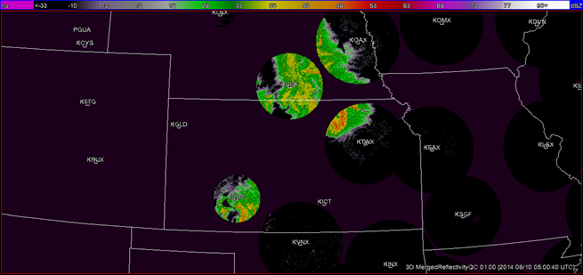
Fig. 2: WSR-88D Constant Altitude Reflectivity Mosaic at 1 km for a MCS over Kansas at 0500 UTC on
10 August 2014. Note the continued poor radar coverage at this altitude.
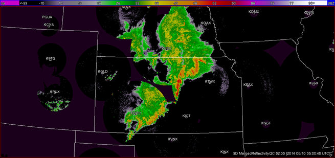
Fig. 3: WSR-88D Constant Altitude Reflectivity Mosaic at 2 km for a MCS over Kansas at 0500 UTC on
10 August 2014. Note the continued poor radar coverage in the Intermountain West at this altitude.
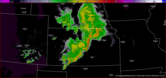
Fig. 4: WSR-88D Constant Altitude Reflectivity Mosaic at 3 km for a MCS over Kansas at 0500 UTC on
10 August 2014. Note the continued poor radar coverage in the Intermountain West at this altitude.
Fig. 5: WSR-88D Constant Altitude Reflectivity Mosaic at 6 km for a MCS over Kansas at 0500 UTC on
10 August 2014. Note the improvement in radar coverage at this altitude.