


Rotation Tracks - Warning Decision Training Division (WDTD)
Navigation Links
Products Guide
Rotation Tracks
Short Description
Maximum Azimuthal Shear in a specified layer for a specified time period.
Subproducts
Low-Level (0–2 km AGL) Rotation Tracks
- 30 minute
- 60 minute
- 120 minute
- 240 minute
- 360 minute
- 1440 minute
Mid-Level (3–6 km AGL) Rotation Tracks
- 30 minute
- 60 minute
- 120 minute
- 240 minute
- 360 minute
- 1440 minute
Primary Users
NWS: WFO, SPC
Other: FEMA, Local EM, Red Cross
Input Sources
Low-Level Azimuthal Shear (0–2 km AGL) or Mid-Level Azimuthal Shear (3–6 km AGL)
Resolution
Spatial Resolution: 0.005° latitude (~555 m) x 0.005° longitude (~504 m at 25°N and 365 m at 49°N)
Temporal Resolution: 2 minutes
Product Creation
Azimuthal Shear Tracks are computed by taking the maximum value of Azimuthal Shear over the specified time period.
Technical Details
Latest Update: MRMS Version 11.5
See the Azimuthal Shear product for technical information.
References
Lakshmanan, V., M. Miller, T. Smith, 2013: Quality control of accumulated fields by applying spatial and temporal constraints. J. Atmos. Oceanic Technol., 30, 745-757.
Miller, M. L., V. Lakshmanan, and T. Smith, 2013: An automated method for depicting mesocyclone paths and intensities. Wea. Forecasting, 28, 570-585.
Applications
Provides a history of the intensity and spatial coverage of strong storm circulations that may be associated with mesocyclones, tornadoes, and/or damaging winds.
Used to determine if a storm has intensified or decayed over time.
0–2-km Azimuthal Shear Tracks have shown enormous utility after events for guidance in immediately directing damage survey ground teams and aircraft, the Red Cross, and other first responders to areas most likely affected by tornadoes.
Example Images
For a Supercell Thunderstorm
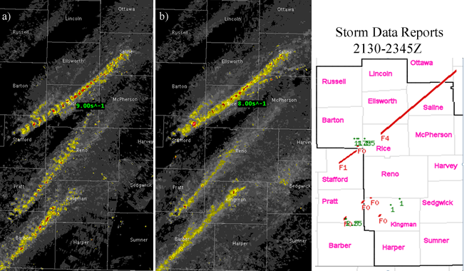
Fig. 1: (a) 120-min Low-Level (0–2-km AGL) and (b) Mid-Level (3–6-km AGL) Rotation Tracks ending at
2345Z on 14 April 2012 for multiple tornadic supercell thunderstorms.
For a Mesoscale Convective System
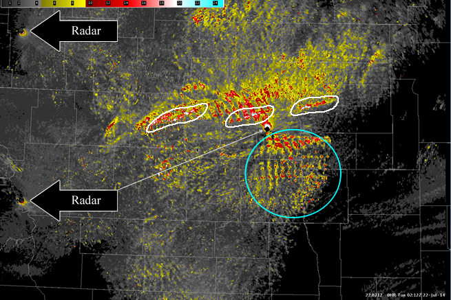
Fig. 2: 120-minute 0–2-km Rotation Tracks ending at 0212Z on 22 July 2014 for a MCS over North
Dakota and Minnesota. The white ovals illustrate tracks associated with tornado reports, while the blue
oval highlights smaller-scale circulations along the leading edge of the bowing segment. Artificially-large
values of Azimuthal Shear surrounding the radar sites are not associated with the storm system.
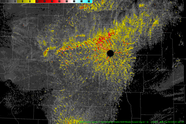
Fig. 3: Same as in Fig. 2, except for 120-minute 3–6-km Rotation Tracks ending at 0214Z.
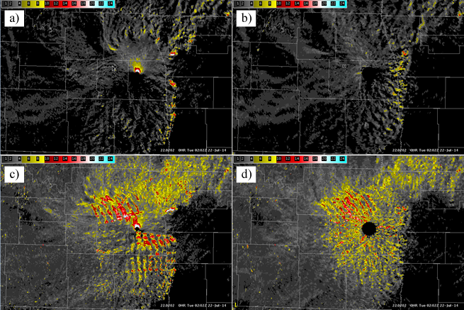
Fig. 4: Azimuthal Shear associated with a MCS over North Dakota and Minnesota at 0202Z on 22 July
2014. Instantaneous Azimuthal Shear for (a) 0–2 km and (b) 3–6 km and 60-minute Rotation Tracks for
(c) 0–2 km and (d) 3–6 km are shown.