


Mountain Mapper QPE - Warning Decision Training Division (WDTD)
Navigation Links
Products Guide
Mountain Mapper QPE
Short Description
Algorithm that improves upon quantitative precipitation estimates (QPE) in the Western U.S. where complex terrain affects radar estimates and gauge density. It uses the Parameter-Elevation Regressions on Independent Slopes Model (PRISM) to create continuous grid estimates of hourly precipitation climatologies to compare against gauge observations. As of Version 12, it is used as an input to the Multi-Sensor QPE product.
Subproducts
- 1-, 3-, 6-, 12-, 24-, 48-, and 72-hour accumulations
Primary Users
NWS: WFO, RFC
Input Sources
PRISM monthly precipitation climatology, HADS and MADIS gauge data
Resolution
Spatial resolution: 1km x 1km
Temporal resolution: Updated hourly at the top of the hour. All products end at the indicated time.
Product Creation
As of Spring 2020, this product is available in two ways (but its creation is the same):
- The operational AWIPS system still supports the MRMS Version 11.5 suite of products; therefore, this product is available in the MRMS menu for viewing.
- As of MRMS Version 12, this product will not be supported as a standalone product, but rather, as an input to the Multi-Sensor QPE. Once Version 12 fully replaces V11.5 on the SBN, you will only be able to access this product via the MRMS Development site.
The Mountain Mapper product is based on a comparison of the Parameter-Elevation Regressions on Independent Slopes Model (PRISM) monthly precipitation climatologies (divided into hourly grids) and the real-time hourly gauge observations, via a ratio bias at each gauge site. PRISM is a tool that uses point measurements of precipitation and temperature, a digital elevation model (DEM), and expertise of complex climatic features to create continuous gridded estimates of monthly climatic parameters. The ratio biases are interpolated onto the MRMS grid, and then multiplied by the normalized PRISM hourly rainfall field to create the Mountain Mapper hourly analysis.
Technical Details
Latest update: MRMS Version 11.5 & 12
Accessible on:
- Version 11.5 -- Operational AWIPS (via MRMS menu)
- Version 12 -- MRMS Development site (since it is only an input to the Multi-Sensor QPE product)
The following steps are only conducted on the one-hour accumulation estimate, since all the other accumulations are aggregates of the one-hour field:
- The PRISM monthly precipitation climatology (Figure 1) is evenly divided into hourly rainfall fields by dividing the monthly grid by the total number of hours in the month.
- A ratio (ek) is computed between the hourly gauge observation (gk) and the normalized PRISM hourly rainfall (pk) at each gauge site that has successfully passed the Gauge Quality Control.

- The ratio bias is then interpolated onto the MRMS grid using a similar inverse distance weighting (IDW) scheme as the Radar QPE w/ Gauge Bias Correction product.
- Unlike the Radar QPE w/ Gauge Bias Correction, the Mountain Mapper product uses predefined IDW parameters, b = 2 and D = 200 km.
- Finally, the interpolated ratio field is multiplied by the normalized PRISM hourly rainfall field to create the Mountain Mapper hourly analysis.
References
Zhang, J., K. Howard, S. Vasiloff, C. Langston, et al., 2011: National Mosaic and multi-sensor QPE (NMQ) system: description, results and future plans. Bull. Amer. Met. Soc., 92, 1321-1338.
Zhang, J., K. Howard, S. Vasiloff, C. Langston, B. Kaney, Y. Qi, L. Tang, H. Grams, D. Kitzmiller, J. Levit, 2014: Initial Operating Capabilities of Quantitative Precipitation Estimation in the Multi-Radar Multi-Sensor System. 28th Conf. on Hydrology, Amer. Meteor. Soc.
Daly, C., R. P. Neilson, and D. L. Phillips, 1994: A statistical-topographic model for mapping climatological precipitation for mountainous terrain. J. Appl. Meteor., 33, 140-158.
Gauge Quality Control documentation
Other MRMS product documentation: QPE – Radar Only, QPE – Radar w/ Gauge Bias Correction
Applications
Mountainous areas cause numerous problems in terms of radar QPE, such as beam blockage, overshooting of low cloud tops, Vertical Profile of Reflectivity (VPR) variations due to beam broadening at long ranges, and loss of orographic enhancement at low levels. The Mountain Mapper is meant for precipitation estimation in complex terrain, particularly in the coastal ranges along the Pacific coast in the Western U.S. Since the mountainous terrain blocks low cloud tops, the Mountain Mapper is best used for cool-season stratiform precipitation (compared to deep convection) in these areas.
Figure 2 displays a precipitation event in the Pacific Northwest from 10 October 2010 with 24-hour accumulation of (a) QPE – Radar Only, (d), QPE – Radar w/ Gauge Bias Correction, and (g) the QPE – Mountain Mapper ending at 1400 UTC. The QPE – Radar Only (Figure 2a-c) underestimated the domain-average rainfall by over 40% with a domain-average root mean square error (RMSE) of 0.41 in. Both the QPE – Radar w/ Gauge Bias Correction (Figure 2d-f) and the QPE – Mountain Mapper (Figure 2g-i) greatly reduced the underestimation of the QPE and had a smaller RMSE; however, the QPE – Mountain Mapper scheme removes nonphysical discontinuities, beam blockage, and other radar artifacts.
Example Images
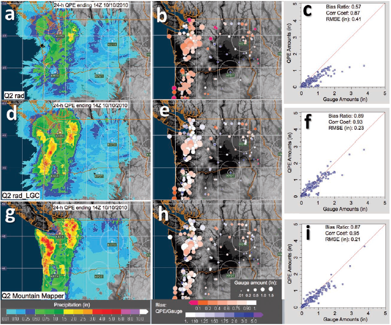
Figure 2. 24-hour accumulations of (a) QPE - Radar Only, (d) QPE - Radar w/ G auge Bias Correction, and (g) QPE - Mountain Mapper ending at 1400 UTC 10 October 2010 in the Pacific Northwest. Bubble charts (b)(e)(h) show the bias ratios between the three different QPE products and CoCoRaHS gauge observations in the domain, where the circle size represents gauge-observed amount and color represents the QPE/gauge bias. Scatter plots (c)(f)(i) show the correlation between the QPE-estimated and the gauge-observed amounts.
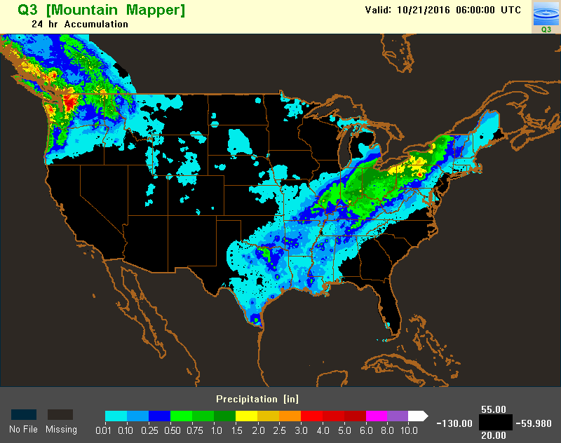
Figure 3. Example of 24-hour accumulation QPE – Mountain Mapper product for 06Z on October 21, 2016.