Probability of Severe Hail (POSH) - Warning Decision Training Division (WDTD)
Navigation Links
- 2D Reflectivity Mosaics
- 3D Derived Reflectivity Mosaics
- 3D Reflectivity Mosaics
- FLASH Products
- Lightning
- Most Useful Products
- Operational MRMS Hydro Products
- Precipitation Quality Control
- Severe Weather
- Reflectivity At Lowest Altitude (RALA)
- Reflectivity at x°C
- Probability of Severe Hail (POSH)
- Severe Hail Index (SHI)
- Vertically Integrated Liquid (VIL)
- VIL Density
- xx dBZ Echo Top (ET)
- MESH Tracks
- Rotation Tracks
- Maximum Estimated Size of Hail (MESH)
- Vertically Integrated Ice (VII)
- Height of xx dBZ Echo Above x°C
- Azimuthal Shear
- ProbSevere
- Supplementary MRMS Hydro Products (not on AWIPS)
- Useful Products for Aviation
- Composite Reflectivity Track 60min
- Layer Composite Reflectivity
- Composite Reflectivity
- Composite Reflectivity Height
- Lightning Probability
- Lightning Density
- MESH Tracks
- Maximum Estimated Size of Hail (MESH)
- Rotation Tracks
- Azimuthal Shear
- VIL Density
- xx dBZ Echo Top (ET)
- Vertically Integrated Ice (VII)
- Vertically Integrated Liquid (VIL)
Products Guide
Probability of Severe Hail (POSH)
Short Description
The probability of 0.75-inch diameter hail occurring.
Subproducts
None
Primary Users
NWS WFO
Input Sources
Vertical temperature profile from the current operational NCEP/EMC mesoscale model (i.e., the RAP as of 2014).
Resolution
Spatial Resolution: 0.01o Latitude (~1.11 km) x 0.01o Longitude (~1.01 km at 25oN and 0.73 km at 49oN)
Temporal Resolution: 2 minutes
Product Creation
A linear correlation of the height of the melting level and Severe Hail Index (SHI) was produced by looking at a number of storm cases (Witt et al. 1998):
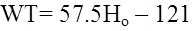
,
where WT (J m-1 s-1) is the warning threshold and Ho (km) is the melting level measured above radar level (ARL). If WT < 20 J m-1 s-1, then WT is set to 20 J m-1 s-1.
The severe hail probability function is given by:
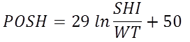
,
where POSH is the Probability of Severe Hail (%). POSH values < 0% are set to 0%, and POSH values > 100% are set to 100%. Despite the continuous nature of POSH, actual algorithm output probabilities are rounded off to the nearest 10%, to avoid conveying an unrealistic degree of precision. Note when SHI = WT, POSH = 50%.
Technical Details
Latest Update: MRMS Version 10
References
Witt, A., M. D. Eilts, G. J. Stumpf, J. T. Johnson, E. D. Mitchell, and K. W. Thomas, 1998: An enhanced hail detection algorithm for the WSR-88D. Wea. Forecasting, 13, 286-303.
Strengths
Like all MRMS products, the use of multiple radars is more robust than single-site radar alone. It provides faster updates and helps the forecaster integrate data from multiple radars. It also compensates for cone-of-silence, beam broadening at far ranges, and terrain blockage.
The use of mesoscale model analysis data to derive temperature information allows the temperature fields to vary across the domain of interest. This is in stark contrast to applying a single temperature altitude proxy across the entire domain, as is often done for single radar calculations. Thus, MRMS data better captures gradients in the temperature fields over space and time.
Limitations
POSH was developed when the NWS severe hail criteria was 0.75-in diameter, rather than the current 1-in criteria. The NEXRAD Radar Operations Center (ROC) determined that a 70% POSH is approximately the same as a 50% chance of 1-in hail.
Subject to the biases and deficiencies of the mesoscale model used to derive the vertical temperature profile.
Quality Control
This product is derived from the 3D Reflectivity Cube, which means non-hydrometeorological data has been removed including: Ground clutter, anomalous propagation (AP), chaff, interference spikes, and bioscatterers (e.g., angels and ghosts). However, bright band contamination remains.
Applications
Useful for storm triage and situational awareness.
Example Images
Fig. 1: Probability of Severe Hail (POSH) for a short-lived severe thunderstorm (white circle) over North
Dakota on 21 July 2014 at 2110Z. POSH is approximately 91% near a SPC storm report of 1.75 inch hail.