


Height of xx dBZ Echo Above x°C - Warning Decision Training Division (WDTD)
Navigation Links
Products Guide
Height of xx dBZ Echo Above x°C
Short Description
The altitude difference (thickness) between a specified echo top (ET) and a specified temperature.
Subproducts
Height of 50 dBZ Echo Above -20°C
Height of 60 dBZ Echo Above -20°C
Height of 50 dBZ Echo Above 0°C
Height of 60 dBZ Echo Above 0°C
Primary Users
NWS WFO
Input Sources
3D Reflectivity Cube
Vertical temperature profile from the current operational NCEP/EMC mesoscale model (i.e., the RAP as of 2014).
Resolution
Spatial Resolution: 0.01o Latitude (~1.11 km) x 0.01o Longitude (~1.01 km at 25oN and 0.73 km at 49oN)
Temporal Resolution: 2 minutes
Product Creation
At each horizontal 2D grid point, the altitude of the specified temperature value (e.g., 0°C) is checked from the top-down. Once the temperature value becomes greater than the temperature being searched for, the altitude is computed by interpolating between the current level and the previous higher level. This calculation method accounts for low-level inversions in the temperature profile by specifically targeting altitudes that are associated with deep convection (e.g., elevated convection over shallow cold layers).
The reflectivity thickness is computed by subtracting the temperature level altitude from the xx dBZ Echo Top altitude.
Technical Details
Latest Update: MRMS Version 11.5
References
Cavanaugh, D. E., and J. A. Schultz, 2012: WSR-88D signatures associated with one inch hail in the Southern Plains. Electronic J. Operational Meteor, 13 (1), 1-14.
Donavon, R. A., and K. A. Jungbluth, 2007: Evaluation of a technique for radar identification of large hail across the Upper Midwest and Central Plains of the United States. Wea. Forecasting, 22, 244-254.
Applications
Positive values imply strong updrafts are present with large reflectivity values at high altitudes.
Negative values imply the storms are shallow, but could be growing.
Building on previous research by Donavon and Jungbluth (2007), a study by Cavanaugh and Schultz (2012) indicated the altitude of the 50-dBZ reflectivity echo relative to the melting level was the most effective 1-in (severe) hail detection method (Figs. 1 and 2) of the four they tested. The 25th percentile threshold was found to score the best.
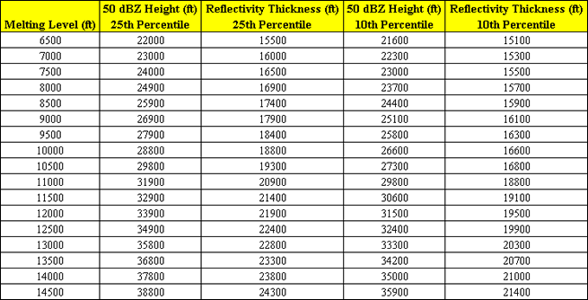
Fig. 1: Severe hail warning criterion from Cavanaugh and Schultz (2012) using the
50 dBZ Echo Top (ft; AGL) and the height of the melting level (ft; AGL).
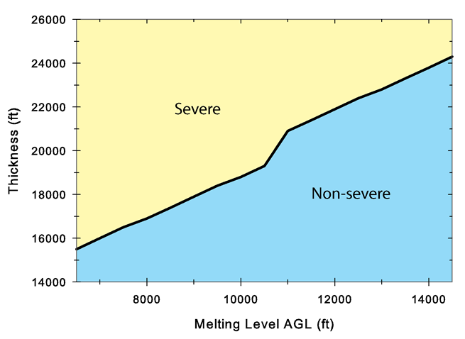
Fig. 2: Graphical representation of hail warning criteria from Cavanaugh and Schultz
(2012) using the 25th percentile threshold of the Reflectivity Thickness and the
height of the melting level AGL. Yellow (blue) shaded region indicates storm is above
(below) warning criterion.
Example Images
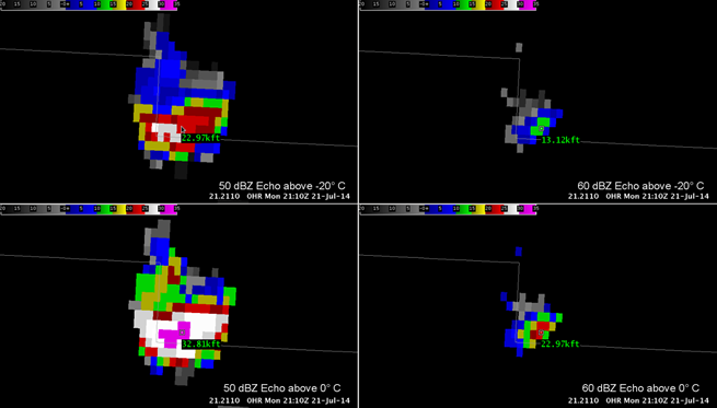
Fig. 3: Height of xx dBZ Echo Above xoC for a short-lived severe thunderstorm over North Dakota at
2110Z 21 Jul 2014. See panel legends for details. SPC storm reports indicate 1.75-in hail was reported
from this storm at approximately this time.