Then and Now: The National Hurricane Center - National Weather Service Heritage
Then and Now: The National Hurricane Center
By Emily Senesac (emily.senesac@noaa.gov)Introduction
Officially founded in 1955, the National Hurricane Center (NHC) has been in existence for almost 70 years, and is a branch of NOAA’s National Centers for Environmental Prediction (NCEP). Among other things, the most important job of the NHC is to provide hurricane and marine forecasts for the tropical and subtropical Atlantic and eastern Pacific Oceans. These lifesaving forecasts help to protect life and property along the coastlines of the United States and across both the Atlantic and eastern Pacific basins..
In the Beginning
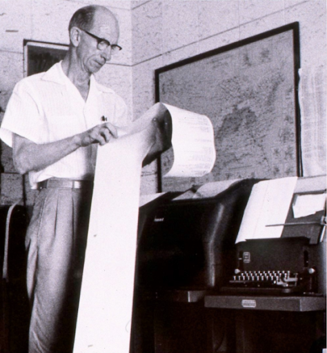
Before NHC was officially formed in the mid-50s, there were several regional hurricane forecast offices that existed in cities up and down the eastern seaboard of the United States, including in Miami. Being in the middle of most of the hurricane action, this Miami office evolved into a joint hurricane warning service, a collaborative effort between the Weather Bureau (the National Weather Service’s predecessor agency, the Air Force, and the Navy. At the time, weather data was received and transmitted via telephone circuits using teletype machines. Local media outlets set up special equipment to ensure that they obtained up-to-date weather information from forecasters.
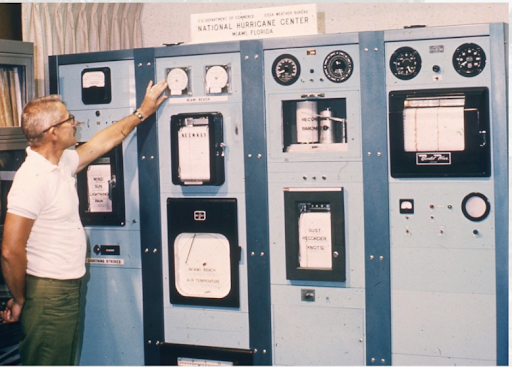
In 1957, the first Weather Surveillance Radar (WSR) was commissioned by the local Weather Bureau office and the hurricane warning office in Miami. This initial stab at the modem radar would later appear in facilities across the country. The installation of this revolutionary technology made forecasting more accurate and reliable. Forecasters would trace weather systems across radar screens using grease pencils, measuring temperature, dew point, humidity, wind speed and direction, cloud type and height, air pressure, and rainfall amounts at least once an hour. A simple turn of a manual crank could change the elevation of the radar, helping forecasters get a clearer picture of the height of a given storm. Once the danger had passed, these observations and forecasts were stored on microfilm and stored away.
1960s and the Satellite Era
As the Miami hurricane warning office evolved into the National Hurricane Center, the teletype remained the most common and efficient way to move data. At this time, the NHC was located in the same building as the local forecast office, and there was a convenient phone number that could be used by the public to get the latest local forecast and hurricane information.
With the arrival of satellites such as the Tiros, Nimbus, and GOES over the course of the decade, forecasters gained an important analysis tool. These vital satellite images were transmitted to the NHC via phone line and were received by a special image processor. Images would then make their way into daily tropics discussions.
1970s and 1980s
As technology continued to improve, so did instrumentation. That said, many of the forecast charts used were still plotted by hand. At this time, there was an entire unit of the NHC that was dedicated to this tedious yet crucial task. At one point, it was the largest unit at the facility.
In 1980, a local amateur radio station was set up at the NHC facility, and became activated whenever a hurricane was within 300 miles of landfall in the west Atlantic, the Gulf of Mexico, the Caribbean Sea, or the eastern Pacific. This technology provided forecasters with supplemental and weather damage data they had not had access to before, such as eyewitness accounts of what people were experiencing during a hurricane.
Beginning in 1988, the NHC hosted a two-week training course with meteorologists and decision makers from member nations of the World Meteorological Organization (WMO) Region IV, which includes North America, Central America and the Caribbean.
The 1990s and Today
In 1992, Hurricane Andrew severely damaged the NHC facility at One Gables Tower. NHC and NWS leaders moved forward with plans to relocate to Florida International University, where they remain today. That same year, the NHC began hosting a Hurricane Preparedness course -- a five-day training designed for emergency managers and other decision makers from Texas to Maine.
Beginning in 2017, storm surge watches and warnings were added to the list of NHC public products, helping to protect coastal communities from this dangerous event. 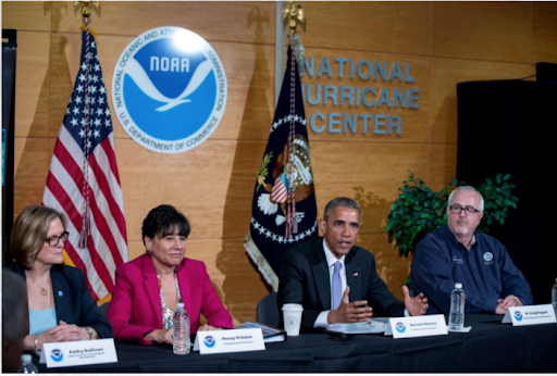
Each year, the President of the United States receives a NOAA briefing regarding the upcoming hurricane season. The NHC facility has been visited in person by two presidents: George W. Bush and Barack Obama.
Today, Hurricane Specialists, in collaboration with NWS Weather Forecast Office partners, use track and intensity forecasts to determine when and where Hurricane Watch and Warnings will be issued. An hour before the release of the latest public advisory for a cyclone, lead specialists will conduct a call to all NWS offices in a watch/warning area. In 2018, that call became a video call.
The Future
Looking ahead to the future, the National Hurricane Center has launched into a new era of applying the latest “research to operations.” The Hurricane and Ocean Testbed (HOT) at the recently opened William J. Lapenta Laboratory will be developing software, testing tools and products, and, if successful, transitioning them into operations for both the NHC and NWS Weather Forecast Offices. Additionally, they will continue to strengthen marine forecasting, focusing on research and product development for the marine forecasting community, including NHC’s Tropical Analysis and Forecast Branch and the Ocean Prediction Center.
In addition to furthering research and technology, the NHC is also using social science to determine the best ways to communicate hurricane messaging to external partners, the media, and the public in a way that is both actionable and easily understood.