
The Start of Tornado Forecasts - National Weather Service Heritage
The Start of Tornado Forecasts
By NOAATornado Forecasts: Getting Started
Some of the first scientific investigations of tornadoes were done by Lieutenant John Finley of the Army Signal Corps. He started his tornado studies in 1878. Based on his studies, he progressed so far as to issue routine tornado forecasts for 18 regions of the country in 1884.
All told, Finley issued 2,803 forecasts, 100 of which called for tornadoes and the rest forecast that no tornadoes would occur. Finley claimed these forecasts were accurate 95.6 to 98.6 percent of the time. Of course, had Finley simply forecast "no tornadoes" in all his forecasts, he would have been right 98.2 percent of the time!
In 1887, General William B. Hazen ordered the termination of tornado forecasting because it was "believed that the harm done by such a prediction would eventually be greater than that which results from the tornado itself."
The First Modern Tornado Forecast
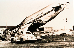
On March 20, 1948, a tornado crossed the runways at Tinker Air Force Base near Oklahoma City, Oklahoma. This storm destroyed 117 aircraft and caused more than $10 million of damage. The base's commanding general instructed the base weathermen that such an event was never to occur again without a forecast.
In investigating the incident, Air Force Captain Robert C. Miller and Major Ernest J. Fawbush found several studies and reports on weather conditions associated with tornadoes. They noticed similarities between the March 20 weather pattern and the findings in these reports.
Five days later, Miller and Fawbush noticed the weather pattern for the day was very similar to the forecast on March 20, when the tornado had struck. When they took their news to the general, he asked if there was a good chance that a tornado would occur that day. After weighing their findings against the probability of another tornado hitting the same spot in less than a week, as well as the potential public backlash from an incorrect forecast, the weathermen answered "yes." Consequently, the general ordered them to issue the nation's first official tornado forecast.
March 25, 1948 tornado.
A few hours later, on the evening of March 25, 1948, a tornado roared through the air base, 100 yards from the track of the March 20 tornado. Rated F3 on the tornado classification, the tornado destroyed 35 aircraft and caused more than $6 million in damage; however, no one was killed and the destruction could have been worse.
This first tornado forecast was instrumental in advancing the nation's commitment to protecting the American public and military resources from the dangers caused by natural hazards.
The Weather Bureau's Severe Local Storms Unit
In response to public demand for tornado forecasts, in 1952, a Severe Local Storms (SELS) unit was established within the Weather Bureau. Their first tornado forecast, issued on March 17, 1952, called for tornadoes in east Texas, south Arkansas, and Louisiana. The forecast was close, but not perfect: tornadoes did occur in north central Texas, but not in Arkansas or Louisiana.
Four days later, SELS issued its second public tornado forecast, this time with more success: the majority of tornadoes occurred in the area the revised afternoon SELS forecast indicated. This model of putting out an early forecast and revising it as the day progressed is essentially the basis for today's watch and warning concept.
Missed Forecasts Lead to Increased Research
The next year, a series of devastating tornadoes occurred. While SELS put out forecasts for these tornadoes, the accuracy of these forecasts varied. During the year, powerful tornadoes inaccurately forecast by SELS hit Texas, Mississippi, and Massachusetts, killing 320 people and injuring over 2,700 others. These misses led to intense research on topics such as the vertical structure of the atmosphere, typical tornadic weather patterns, and the role of the jet stream in severe weather.
Civilian tornado forecasts remained in relative obscurity until April 2 and 3, 1956. On these dates, SELS issued afternoon tornado watches in Wisconsin and lower Michigan. Four tornados occurred in the watch area - an F5, two F4s and an F3. The accuracy of this forecast was truly amazing, given that the unit had no centrally available radar, no computer model guidance, no satellite data, and limited communication capabilities. The forecasts issued for these four tornadoes demonstrated the potential for credible tornado forecasting.
Since the 1956 tornadoes, forecast capabilities have continued to improve with advances in storm analysis, Doppler radar, satellites and interactive computers, storm modeling, and greater understanding of interactions between storms and the environment.
From "Forecast" to "Watch"
The 1965 Palm Sunday tornado outbreak was a seminal event in tornado forecasting history and a turning point for the National Weather Service. During the outbreak, a massive double-funnel tornado near Dunlap, Indiana, between Goshen and Elkhart, killed 266 people despite the fact the tornadoes were generally well forecast. As a result, the Weather Bureau began to search for flaws in their system. They found the public did not know about and appreciate the Weather Bureau's capability to forecast tornadoes and did not understand the tornado hazard.
The survey team outlined an aggressive public education program, including the "Owlie Skywarn" program, which serves to warn children about the dangers of severe weather.
Also, following the Palm Sunday outbreak, three specific changes in tornado forecasting procedures occurred: the term "tornado watch" replaced "tornado forecast," the procedure used to define the area inside a watch was standardized, and the forecast of potential areas of severe thunderstorm activity was made a public product. A "watch" means severe weather is possible during the next few hours, while a "warning" means that severe weather has been observed, or is expected soon.
Advances in radar technology, and improved understanding of thunderstorm development, have produced improvements in tornado watch and warning lead times. Severe thunderstorms that generate tornadoes often produce large hail, lightning, and strong winds. These tornadoes can develop at any time of the year, but major outbreaks are often associated with the transition period between winter and spring and fall to winter.