
The Satellite Era Begins - National Weather Service Heritage
The Satellite Era Begins
By NWS Heritage Projects Editorial StaffThe following appeared in the March 1960 issue of Weather Bureau Topics:
launch. Photo by NASA.
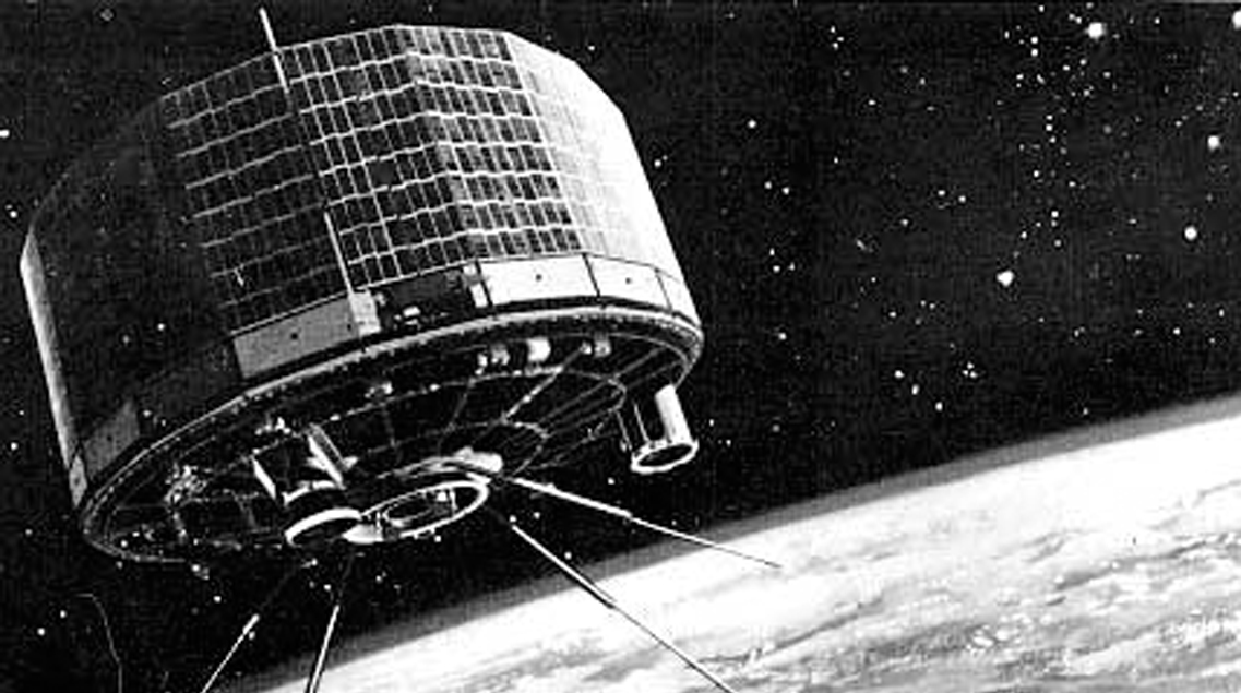
At 6:40 am EST on April 1, 1960, a three stage 90-foot tall Thor-Able rocket lifted a drum shaped, 270-pound satellite from the launching pad at the Atlantic Missile Range at Cape Canaveral.
Shortly afterward, NASA authorities announced that TIROS I, the United States Meteorological Satellite was in circular orbit around the earth with its perigree at about 435 statute miles and its apogee at 468 miles above the surface of the earth.
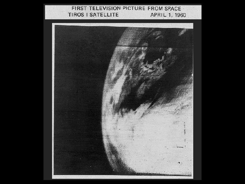
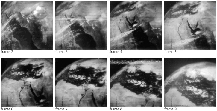
Within five hours after the launching, President Eisenhower viewed photos taken during TIROS' second orbit of the earth and termed the whole thing "a marvelous development." The photos the President saw were taken by one of two television cameras mounted in the satellite to take still photographs of the earth's cloud cover.
NASA officials called the shoot one of the most perfect global orbits ever achieved. The New York Times said that it is "a marvel of electronic ingenuity" and even the most conservative of meteorologists hailed the development as a revolutionary step in advancing the science.
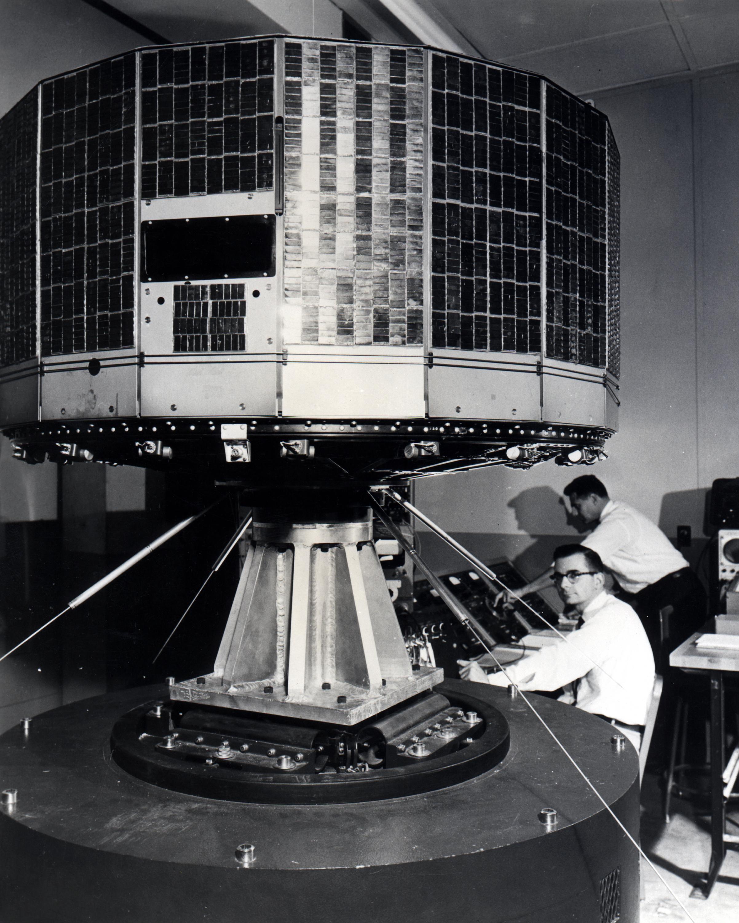
Beside the specially designed miniature television cameras, the satellite contains video tape recorders, transmitters, solar cell and rechargeable battery power supplies, and an array of control and communications equipment.
As it circles the earth every 99 minutes, the satellite is linked to an extensive ground network of tracking and receiving stations, data processing systems, and programming and control centers.
During its planned operation lifetime of 90 days, TIROS I is expected to complete about 1300 orbits covering every part of a belt from the latitude of Santa Cruz, Argentina, in the south, to the latitude of Montreal, Canada, in the north.
There are two primary ground stations which can both command the satellite and receive photo data. These are located at Ft. Monmouth, New Jersey, and Kalena Point , Hawaii.
The two TIROS TV cameras differ in coverage and resolution. The wide-angle camera is designed to cover an area of cloud roughly 800 miles on a side. The high resolution or telephoto camera will photograph a smaller area located within the wide-angle camera's view. Out of ground station range, TIROS can record up to 8 photographs on the storage tape for later relay.
At the ground stations, pictures are displayed on kinescopes for immediate viewing and photographing.
Planning TIROS, placing it in orbit, tracking, and acquiring, processing and analyzing the data has required the cooperation and assistance of many government agencies and industrial organizations. The over-all responsibility for the project rests with NASA.
The operational phase of the project is under NASA's Computing Center and the Weather Bureau's Meteorological Satellite Section. NASA's Goddard Space Flight Center prepares the command programming which the ground stations relay to the satellite.
Meteorologists in the Bureau's Satellite Section are responsible for the analysis and interpretation of cloud cover data, Assisting the Weather Bureau and NASA in weather data analysis will be the Air Force Cambridge Research Center, Allied Research Associates, Air Weather Service, Navy Research Weather Facility, and the Army Signal Corps. The U.S. Naval Photographic Intrepretation Center will develop and process photographs.
Two of the basic limitations of TIROS are that its orbit does not permit it to view conditions over the polar regions and because of its space orientation, TIROS views the earth only part of the time. Work is progressing now on a satellite to be called NIMBUS that will correct both these handicaps. NIMBUS will be put up in a polar orbit, always facing the earth.
TIROS I is an experiment but its success already points the way for work on future weather satellites. TIROS II, which is planned for launching this summer, will contain infra-red detection devices to measure the earth's heat budget.
Future weather satellites now being planned will carry improved television cameras for more detailed pictures of cloud cover and storm formation. They will also carry small radars for measuring the thickness of the clouds and for spotting rain and snow.
Further reading:
Celebrating the World's First Meteorological Satellite: TIROS-1 (NESDIS):
https://www.nesdis.noaa.gov/content/celebrating-world%E2%80%99s-first-meteorological-satellite-tiros-1
50th Anniversary of the TIROS Satellite (NASA):
https://earthobservatory.nasa.gov/images/43401/50th-anniversary-of-the-tiros-satellite
TIROS, the Nation's First Weather Satellite (NASA):
https://www.nasa.gov/multimedia/imagegallery/image_feature_1627.html