
The NWS Modernization and Associated Restructuring - A Retrospective (Part 1) - National Weather Service Heritage
The NWS Modernization and Associated Restructuring - A Retrospective (Part 1)
By Dan Valle (Dan.Valle@noaa.gov)In early April 1974, 150 tornadoes -- including six F5s and 24 F4s -- touched down across 13 states, leaving 314 killed and a path of destruction in its wake. This “superoutbreak” of tornadoes was a turning-point in NWS history, spurring what would become the mostly ambitious, and ultimately successful transformation in the agency’s history: the Modernization and Associated Restructuring, or MAR.
Planned in the 1980s and implemented in the 1990s, the MAR vastly modernized the agency’s observational infrastructure, radically changed the NWS field office structure, and staffed them with degreed meteorologists and hydrologists with advanced training in the new systems to ensure more rapid detection of storms and deliver timely forecasts and warnings to the public.
As is the case today, many of the Nation’s deadly weather events occur within a matter of minutes. Researchers demonstrated that prototype observing technologies and information processing systems could significantly improve weather warnings and forecasts. These new technologies rendered existing systems of the time obsolete. The new technologies would provide high resolution, time variant, three-dimensional data. However, this new technology with its large amount of complex information would require higher levels of analytical and interpretive skills by forecasters.
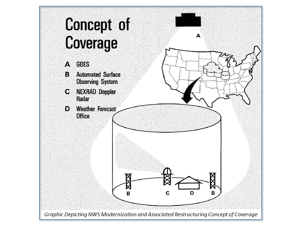
Several technologies emerged during MAR. The Automated Surface Observing System (ASOS) improved warnings and forecasts by observing and transmitting changing weather conditions as they were occurring. The Next Generation Weather Radar, or NEXRAD, could observe the speed and direction of tornadoes and dangerous thunderstorms while aiding flood forecasts and warnings by providing precipitation measurements. Previously, as in the 1974 superoutbreak, tornado warnings were issued only when a tornado sighted. Satellite upgrades included the Geostationary Operational Environmental Satellite (GOES) I-M system which could produce visible and satellite imagery every six minutes. In addition, GOES I-M had instrumentation allowing simultaneous image and sounding data to be observed and transmitted. Improved modeling was necessary, achieved through the acquisition of Class VII computers whose processing capability was an order of magnitude greater than the Class VI computers. The Advanced Weather Interactive Processing System (AWIPS) was the centerpiece of the system, integrating and displaying data at forecasters’ fingertips, giving meteorologists the ability to make decisions, prepare warnings and forecasts, and disseminate products more quickly.
While NWS operations have advanced greatly in the years since the MAR, the basic operational concept remains. The technological advancements afforded by NEXRAD allowed for improved services through a new concept of coverage across the United States consisting of a uniform arrangement of 115 conterminous cylinders. Each cylinder had a radius of roughly 125 miles with a Weather Forecast Office (WFO) located in the center. The cylinder represented the area of operational responsibility for the WFO with data from GOES, NEXRAD, and the National Centers pouring into AWIPS.
In the new structure, the WFOs became responsible for all warnings and forecasts within their area of responsibility. Guidance products issued from the National Centers and River Forecast Centers (RFCs) supported the WFOs. RFCs would provide hydrologic forecasts and guidance related to mainstem rivers and flash flooding. Also, the RFCs would provide long-term seasonal forecasts regarding snowmelt and water supply outlooks. Each of the RFCs were to be colocated with a WFO resulting in more effective utilization of information and cost savings through shared facilities. Before the MAR, RFCs operated on one forecast per day based on manual observations taken in the morning. With access to more sophisticated data, the RFCs expanded operations to an average of 16 hours per day and occasionally work 24 hours during high impacts periods.
The National Meteorological Center (now part of the National Centers for Environmental Prediction) would continue to collect and analyze domestic and international data. Interestingly, there was hope that the Class VII computers would greatly increase resolution so that the extended forecast period could be moved from 3-4 days to 36 hours. This would free local forecasters to devote attention to short-term weather events.
The Climate Analysis Center (today’s Climate Prediction Center) was created to support the National Climate Program Act. As such, they were not directly affected by the MAR. However, they were co-located with the National Meteorological Center, which enabled them to take advantage of the data, computers, and scientific expertise.
The National Hurricane Center and the National Severe Storms Forecast Center would continue to analyze, predict, and track topical systems and severe thunderstorms, respectively. The technological advances such as new satellites, radar stations, ASOS, and AWIPS would help improve forecasts.