
Numerical Weather Prediction - National Weather Service Heritage
Numerical Weather Prediction
By Chris Geelhart (chris.geelhart@noaa.gov)From the National Weather Service's very beginnings in the early 1870's, a key goal was to predict the weather to protect lives and property. Early methods using rules of thumb and simple extrapolation of observations gave way to more advanced forecasting as the science of meteorology progressed. The development of computers after World War II and the significant increases in computing power since have allowed the ability of computer weather models to improve ... both in what can be predicted, and the length of time in the future.
Early Efforts
Before the advent of computers, attempts at manual calculations were time intensive, to say the least. In 1922, Lewis Fry Richardson, an English meteorologist, published his ideas in Weather Prediction by Numerical Process using procedures developed by Vilhelm Bjerknes. Early attempts to manually produce a 6-hour forecast for two points took at least 6 weeks. In Richardson's case, the results were so grossly in error that future attempts were not tried until 1948.

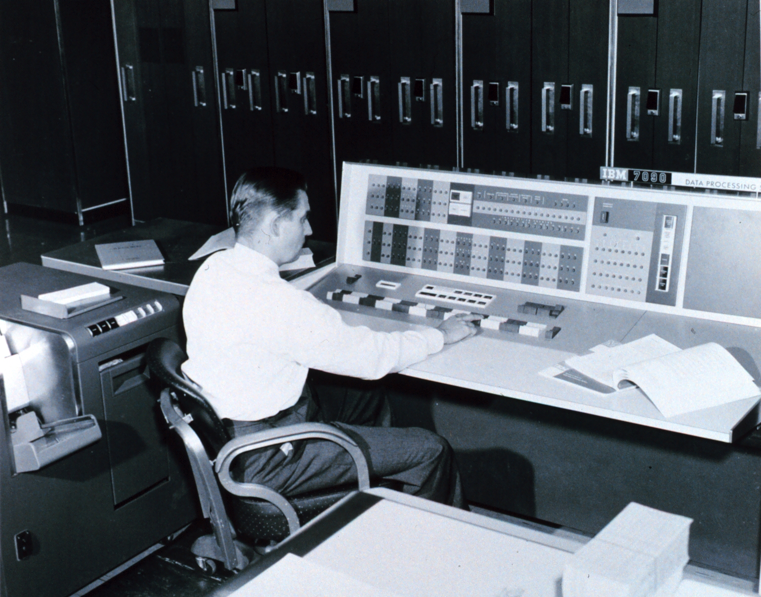
In the late 1940's, the Weather Bureau and scientists at Princeton University organized to explore the potential for using computers to predict the weather. By 1950, details had been fleshed out enough to create four 24-hour forecasts using the Electronic Numerical Integrator and Computer (ENIAC) machine at the Aberdeen Proving Grounds in Maryland. While the Princeton group continued their efforts, the Joint Numerical Weather Prediction Unit was established on July 1, 1954 in a joint effort by the Weather Bureau, the Air Weather Service, and the Navy Aerological Service. The new unit was led by Dr. George P. Cressman, who would later become the Chief of the Weather Bureau in 1965. The December 1954 edition of Weather Bureau Topics summarized its function:
"The purpose of the Unit is to convert to routine procedure the forecasting methods developed through research in Numerical Weather Prediction (NWP), and to produce prognostic weather charts on an operational basis using the numerical techniques. It has long been a goal in meteorology to obtain an accurate quantitative answer to the problem of describing the atmosphere by means of the basic physical equations, but until recently, efforts in that direction have been stalled by the seemingly endless calculations required."
Weather Bureau forecasters began to receive the numerical weather forecasts in real time in 1958, and by 1960, some of the products were surpassing the quality of the ones computed manually. While skill was seen in some of the forecast elements aloft, there was still some difficulty translating their impacts to the weather at ground level. This took some time to resolve, as some of the smaller scale features at the surface couldn't be factored into the larger scale models. With the limitations, forecasters continued to view model output with some skepticism. However, with time, model guidance became a critical tool for forecasters.
How a Model Works
At its core, a weather model uses mathematical equations of the atmosphere to project the weather. Weather observations from the surface and aloft are input into the model, and the models calculate the results of these equations in specific time increments from the present. Models can calculate the weather on a larger scale, or can provide much higher detail at a smaller scale. Many different parameters are output from the model, such as barometric pressure, temperature, wind speed and direction, and precipitation amounts at the surface. Several different models are available for forecasters to use, and each one is evaluated to determine if it is correct for a given situation. If there is good agreement among these different models, then the forecaster has increased confidence in the expected conditions. Poor agreement leads to more uncertainty in the forecast.

(Image from NWS Jetstream education site)
 Tweaking the Observations
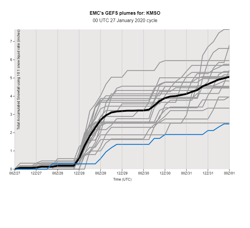
One particular method used in NWP is referred to as ensemble forecasting. In this method, a set of forecasts are created from the same model, with the initial conditions slightly changed from run to run. The amount of variation (or "spread") in the output indicates the confidence.
In this particular example, an ensemble of snowfall forecasts for Missoula, Montana is given. The first 36 hours of the forecast (up to the "12Z/28" line, representing 5 am MST on January 28, 2020) shows that the individual model outputs (or "members") are in good agreement, since the plotted lines are close together. However, after that, a large range is presented, which is significantly higher than the main model itself (shown as the blue line). When there are significant ranges in the output, the uncertainty in the results is increased. Meteorologists will take this into account when formulating the forecast.
Running the Models
NWS models are run by the National Centers for Environmental Prediction (NCEP) Central Operations branch. Two supercomputers are located in Reston, VA, and Orlando. The most recent upgrades to these systems resulted in a computing speed of 4.2 petaflops at each site, with 60 percent more storage capacity. The output of these models is available at https://mag.ncep.noaa.gov/ .
NWS forecasters also have access to models run elsewhere. Models from the European Center for Medium-Range Weather Forecasting and Environment Canada are used, and several universities run their own models on a small scale. Model output is also blended into a system known as the National Blend of Models, to allow a common starting point for the forecast.
Additional Reading:
- 100 Years of Progress in Forecasting and NWP Applications, Stanley G. Benjamin and John M. Brown (2019) - AMS Journal [PDF]
- History of Numerical Weather Prediction at the National Meteorological Center, Frederick G. Shuman (1989) - AMS Journal [PDF]