
Introducing NEXRAD - National Weather Service Heritage
Introducing NEXRAD
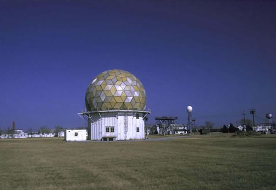
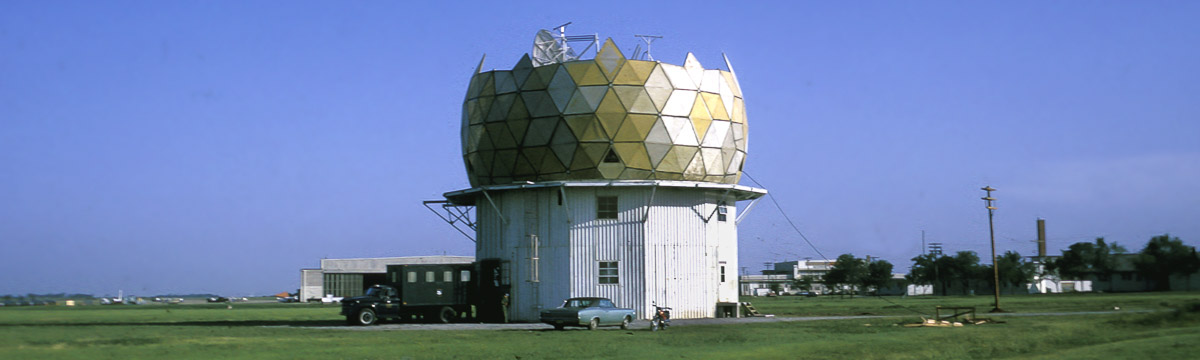
By NWS Heritage Projects Team (nws.heritageprojects.team@noaa.gov)Above: Research Doppler radar near Norman, OK in 1970, with WSR-57 radar seen to the right. (National Severe Storms Laboratory photo)
The following article by Don Witten appeared in the Winter 1984 edition of NOAA Magazine.
Steadily, the 30-foot diameter radar dish rotated, sweeping the Oklahoma prairie with a narrow pencil beam of radio frequency pulses. The pulses, measuring 10 centimeters (4 inches) in wave length, penetrated a large thunderstorm some 50 miles to the southwest. Some of the energy was reflected by raindrops in the storm back to the radar antenna.
Inside the control room of the experimental Doppler weather radar at NOAA's National Severe Storms Laboratory (NSSL) in Norman, Okla., the storm showed up as a color-coded mass on the radar's television screen.
Examining the monitor, NOAA researchers Don Burgess and Ken Wilk saw the closely spaced red and green areas near the edge of the storm. The bright green area identified wind-driver, raindrops moving rapidly towards the radar. The adjacent red area revealed rain moving away from the radar. The telltale sign was obvious to the two researchers: rain was spiralling in a tight vortex of wind that in minutes would become a tornado.
Speaking quickly into the telephone, Wilk briefed Lead Forecaster Joe Kendall at the Oklahoma City Forecast Office of the National Weather Service, just 20 miles away.
Kendall already had recognized the classic signs of a severe storm so common in the Oklahoma springtime. But the monitor of his 1957-vintage radar revealed no "hook-echo,” the rare sign of a forming tornado. This distinctive hook-shape is produced sometimes by conventional radar signals reflected from swirling raindrops inside a storm. Within minutes, however, Kendall issued a tornado warning. It was to be the first of 13 warnings issued that evening of May 11, 1982—all with an average lead time of 29 minutes. Each was based on the forecaster's skill and experience, plus the added information from the test Doppler weather radar at nearby Norman.
"Such advance tornado warnings, coupled with low false-alarm rates, will be possible on a routine basis once we make operational Doppler weather radars available to our forecasters,” said Dr. Richard E. Hallgren, Director of National Weather Service. "Years of research and operational experience with experimental Doppler radars at NSSL and a few other locations have set the stage for the development of a new, and sorely needed national Doppler weather radar network.”
The first operational units of a new Doppler weather radar are scheduled for installation in 1988. A national network of 160 new weather radars, many of them Doppler units, is planned for 1992.
This ambitious effort is called NEXRAD, the Next Generation Radar program. It is a joint undertaking by the Departments of Commerce, Defense and Transportation to replace the Nation's weather radars. Most of these units are based on the vacuum tube technology of the mid-1950's.
Organizations within these Departments—the National Weather Service, the Air Weather Service, the Naval Oceanography Command, and the Federal Aviation Administration—provide the severe weather warnings for the American public, military installations and areas of operation, and the civil air ports and airways. All use weather radars which, for the most part, are becoming more unreliable and difficult to maintain with use and age.
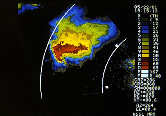
on May 22, 1981. (National Severe Storms Laboratory
photo.)
The Department of Commerce now has two U.S., high-technology firms under competitive contract to develop and verify the design of the new Doppler weather radar. One of these firms will be selected to produce about ten Doppler units for early field evaluation and for full-scale production by 1988.
According to Tony Durham, the NEXRAD Program manager, "joint use of the new radars by the three organizations will minimize the total number of units needed to provide coverage for this country. The 160 units planned under the NEXRAD program also will include 15 radars necessary for military installations overseas.”
There are now about 230 conventional weather radars deployed across the United States. Some 80 of these form in a national network to provide coverage in most of the conterminous states for warnings of severe thunder storms, tornadoes, significant rain and snowfall, and hurricanes. Another 150 local warning radars supplement the national network in areas of high storm risk or where national network cover age is inadequate.
Like conventional weather radar, NEXRAD's Doppler radar sends out repeated radio pulses and monitors their echoes from approaching storms as a way of measuring the storm's intensity and distance. By means of the Doppler principle, this new weather radar also will measure the shift in frequency of its signals reflected from raindrops. With this information, the direction of the storm's wind-drawn rain and, hence, the wind field can be detected to provide strong clues or signatures of developing tornadoes and other severe weather phenomenon.
Here's how the Doppler shift of rain reflected radio signals occurs: Radio signals reflected from raindrops moving towards the radar are compressed due to the added effect of the forward movement of the rain. Conversely, radio signals reflected from raindrops carried by the wind away from the radar are stretched out. Compressed signals shift to a higher frequency whereas those stretched out shift to a lower frequency.
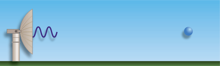
The most common example of the Doppler principle, named after the 17th century physicist Johann Christian Doppler, is the pedestrian's observation of an automobile horn blast that rises in pitch as the vehicle approaches and drops as it passes.
The new Doppler weather radars being developed under the NEXRAD program are total, computer-aided systems. They will process and display the reflected radar signals, including the Doppler data, into meaningful information. This will allow the forecaster to identify the type of storm, project where it is moving, detect early signs of tornadoes, and identify the expected amounts of rainfall.
Computer programs will be incorporated in the NEXRAD Doppler radar systems to estimate the amount of rain falling in severe storms and match that with the shape or capacity of local water sheds. This capability will allow meteorologists and hydrologists using the new Doppler radars to improve their fore casting of flash floods, which claim an average of 200 American lives annually.
The NEXRAD Doppler weather radar will transmit signals at the 10 centimeter wave length, the frequency judged best for use in a general purpose weather radar network. At this frequency, signals focused in a pencil like beam by a 24-foot diameter dish antenna can penetrate nearby storms to spot those further away out to 100 miles. "Ten centimeter radar signals are attenuated 16 times less than those at half the wave length by atmospheric constituents such as water droplets, dust, and flocks of birds and insects,” said Dr. Joe Friday, Deputy Director of the National Weather Service.
Although the limitations of shorter wave length signals have been known for some time, they were demonstrated tragically in 1976 by the crash of a commercial aircraft near Atlanta, Ga. A short wave length radar in the cockpit indicated that one area in a line of thunderstorms ahead of the plane was thin. The pilots flew into that area to avoid the storm.
"It turned out that the radar had detected only the leading edge of an intense thunderstorm laden with rain. Although the plane made it through the storm, water stalled its engines. Over 70 people were killed in the crash,” Friday recalled.
He added that the storm penetrating capabilities of the 10 centimeter weather radar permit the use of only a quarter of the number of 5 centimeter units that would be required to cover the U.S.
NSSL began using a 10 centimeter wave length Doppler weather radar to study wind fields within severe storms as early as 1971. Since then, the existence of two useful severe storm features with characteristic signature patterns have become apparent.
The first is that of a mesocyclone—a vertical column of rising, rotating air that measures 6 to 12 miles across. This signature is seen first in the mid-part of the storm and descends to the cloud base as a tornado forms. Generally, it is in the region of the mesocyclone that a severe storm contains the largest hail, strong est winds, and tornadoes.
The second pattern, the tornado vortex signature, is produced by the tornado itself. This is the location of rapidly changing wind speeds contained in a region much smaller than the parent mesocyclone of which it is a part. Although detectable at relatively short range, this signature has the greatest utility for identifying a tornado's location within half a mile.
By 1977, the civilian and military users of weather radar pooled their talents to conduct the first operational test of a 10 centimeter wave length Doppler weather radar at NSSL. Called the Joint Doppler Operational Project (JDOP), it had the added mission of outlining specifications of a new generation of weather radar for national network use. JDOP participants included NOAA's National Weather Service and Environmental Research Laboratories; the Air Force's Air Weather Service and its Geophysics Laboratory; and the Federal Aviation Administration.
Beginning with the 1977 severe weather season, the JDOP conducted 3 years of intensive operational research with NSSL's experimental Doppler weather radar. During this effort, the JDOP meteorologists detected 70 per cent of the tornadoes which occurred within range of its radar. The undetected twisters were the weaker and short-lived tornadoes which pose a lesser threat to public safety.
As part of their evaluation, the JDOP meteorologists prepared severe thunderstorms and tornado advisories based on the Doppler weather radar observations. These were compared to the public warnings issued for the same storms by the National Weather Service Fore cast Office at Oklahoma City, which bases many of its warnings on public reports of tornado activity near or on the ground. A cadre of dedicated volunteer tornado spotters provide most of these reports.
"Lead time for the tornado advisories prepared with the Doppler information was 20 minutes on the average, compared with just over 2 minutes for the public warnings,” said Dr. Edwin Kessler, NSSL director. "In addition, the Critical Success Index for the test advisories was nearly twice as high as the public warnings. This index gives credit for a high probability of tornado detection and low false alarm rates.”
During the JDOP tests, aircraft flew through the Oklahoma thunderstorms being monitored by the Doppler unit to make direct measurements for comparison. It was determined that Doppler weather radar can detect dangerous gust-fronts, wind shear, and in-storm turbulence. Consequently, NOAA researchers are confident that Doppler weather radars also can be used as a warning tool for aircraft.
Dr. Friday recalls one significant event during the JDOP which convinced the Department of Defense that it should be involved in the NEXRAD program. As an Air Force officer, then, he briefed Secretary of Defense Brown on the following incident: On May 2, 1979, a JDOP advisory was made available to Vance Air Force Base in Enid, Okla. It provided 2 hours' advanced notice that a severe storm with a mesocyclone was headed in the direction of the military installation. Based on this advisory, 52 T-38 training aircraft were moved inside hangers. As the storm passed, it spawned tornadoes on either side on the base and deposited large hail across the Air Force facility.
"Prevention of damage to the aircraft, valued at about $3 million each, saved nearly enough money to pay for DOD's participation in the NEXRAD program," Friday said.
Radar—Radio Detection and Ranging—dates back to the 1886 work of Heinrich Hertz, who first observed reflections of radio signals from solid objects. The first practical radar was developed in the early 1930's by Sir Watson Watt of Great Britain and used to direct aircraft during World War II. Although Doppler data were present in the first radars, it was considered a nuisance. One of the challenges during the second World War, Dr. Friday remembers, was to eliminate this extraneous "weather noise” from the military radars.
By 1947, the U.S. Weather Bureau (now called the National Weather Service) recognized the value of radar for storm monitoring and began using converted military radars. The Weather Bureau's first radar designed specifically for weather monitoring was procured in 1957. Most of the weather radars in use today are of this vintage, although a limited number of today's weather radars were built in 1974, based on an improved design.
"It is ironic that the weather radar intended for use in the 21st century is based on the Doppler weather noise designed out of the very first radars developed,” Friday said.
For more information:
- History of the National Severe Storms Laboratory
- Historical images from the Norman research Doppler radar (National Severe Storms Laboratory website)
- How Radar Works (NWS Jetstream education website)