For the seventh consecutive year, NWS Huntsville provided on-site weather support for a large outdoor country music concert in Cullman, Alabama this past weekend. This concert is usually held in June, one of the most problematic times of year for forecasting due to the seemingly-random nature of summertime convection. Public safety officials have had to stop the concert once for the threat of cloud-to-ground lightning and gusty winds, and have come close on several other occasions.
This year’s event was no exception. On Friday night, June 1, a small multi-cell cluster of storms containing cloud-to-ground lightning developed approximately 30 miles to the west and moved steadily east, putting forecasters and public safety officials alike on alert.
In past years, NWS Huntsville forecasters have used the North Alabama Lightning Mapping Array for situational awareness. Unfortunately, the NALMA is no longer available, but NWS Huntsville is a Preliminary Test & Evaluation site for the GOES-16 Geostationary Lightning Mapper (GLM). So forecasters at both the NWS office and the concert used GLM to evaluate the threat to almost 30,000 people.
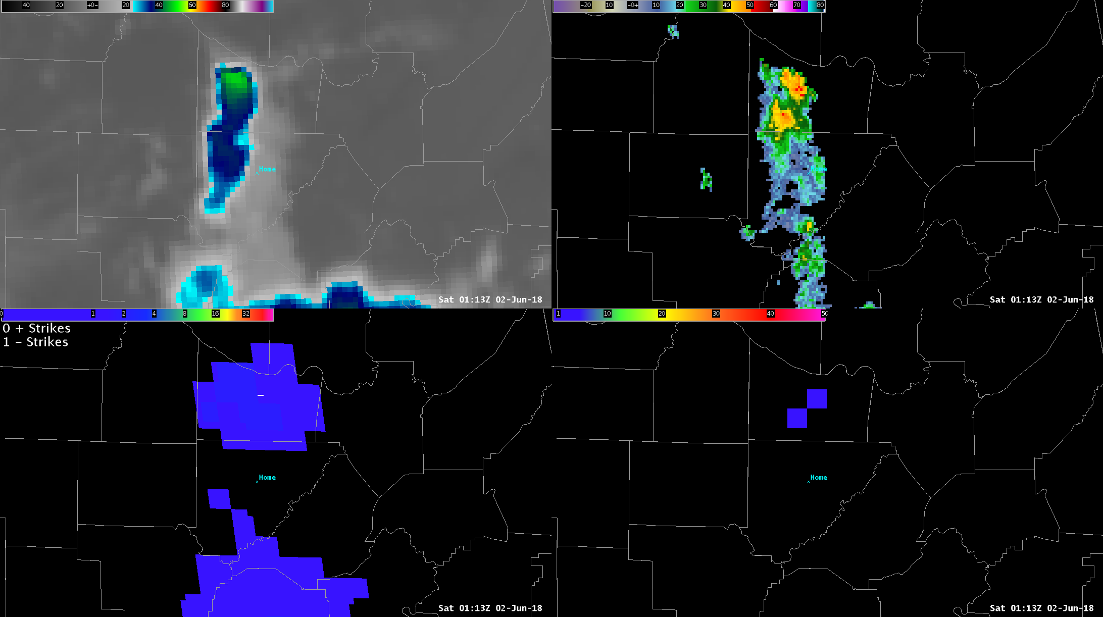
Four Panel image of GOES-16 Clean IR (top-left), MRMS radar reflectivity (top-right), Earth Networks 8-km total flash density (bottom-right), and GLM FED and NLDN plot (bottom-left), vallid 0113 UTC 1 June. The concert is denoted by the crosshairs marked “Home”.
Fortunately, the initial cluster of storms to the west essentially “split”, with one updraft gaining dominance to the south, and the rest weakening. There were some “long flashes” extending far to the north from the southern storm, and far to the south from the northern storm, as seen in the image above.
The storm to the south produced a great deal of lightning, but thanks to the GLM Flash Extent Density product, forecasters were able to determine that the concert would not be affected.
As the storm to the south was weakening, the northern storm regained strength and intensified. GLM FED data shows several flashes moving into the 10 nautical mile range ring, and one moving within the 5-nm ring. Public safety officials and forecasters were certainly concerned. However, forecasters were able to combine GLM FED information with GOES-16 IR and Multi-Radar/Multi-Sensor radar data to determine that the storm was moving away, the updraft was intensifying (which typically leads to smaller flashes), and the lightning threat would gradually diminish.
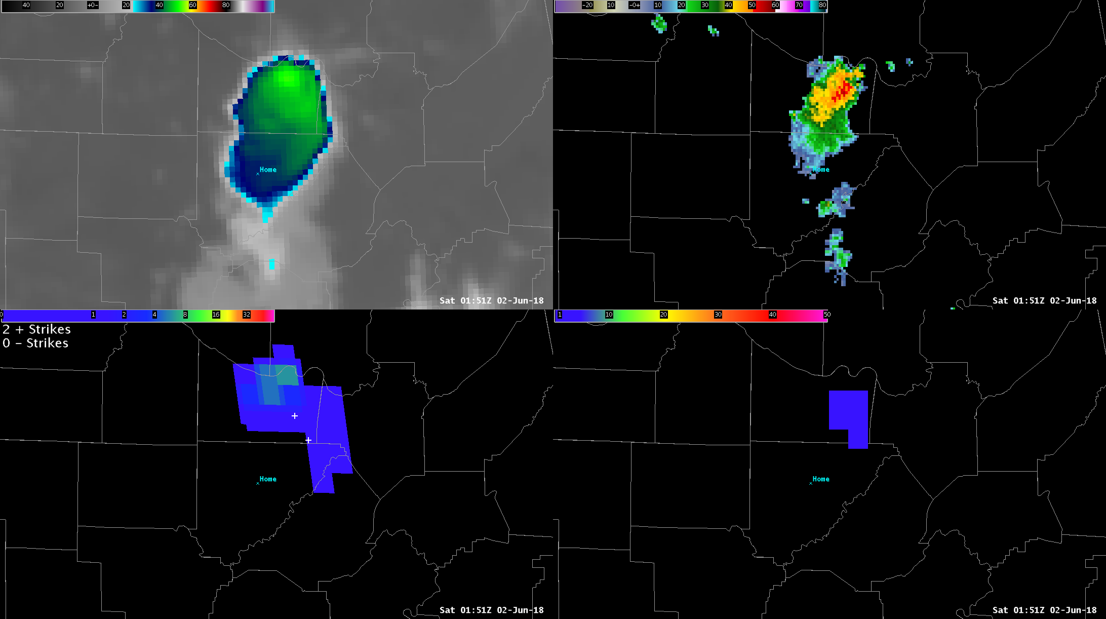
Four Panel image of GOES-16 Clean IR (top-left), MRMS radar reflectivity (top-right), Earth Networks 8-km total flash density (bottom-right), and GLM FED and NLDN plot (bottom-left), vallid 0151 UTC 1 June. The concert is denoted by the crosshairs marked “Home”.
The northern storm would eventually produce quite a light show for skywatchers in the Huntsville metro area–but it also did much more. Later on, GLM FED data indicated a lightning increase at 0207 UTC, followed by a more pronounced increase at 0216 UTC.
Animation 0156-0259 UTC of GOES-16 Clean IR 1-minute imagery (top-left), MRMS radar reflectivity (top-right), Earth Networks 8-km Total Flash Density (bottom-right), GLM FED and NLDN plot (bottom-left).
Indeed, this storm eventually downed numerous trees along the Madison-Marshall county line around 0240-0250 UTC.
With our legacy of using LMA data for almost 15 years, NWS Huntsville forecasters have embraced GLM FED data eagerly. We hope to share more operational examples in the future.
Re-posted from: https://nasasport.wordpress.com/2018/06/07/operational-utility-of-glm-flash-extent-density-on-june-1/


