


Reflectivity At Lowest Altitude (RALA) - Warning Decision Training Division (WDTD)
Navigation Links
Products Guide
Reflectivity At Lowest Altitude (RALA)
Short Description
Reflectivity at the lowest sampled vertical level that contains data.
Subproducts
Low-Resolution (5 km) RALA
Raw RALA, un-quality-controlled RALA
Primary Users
NWS: WFO, CWSU, RFC, AWC, SPC, WPC
FAA: Tower, AFSS
Other: EM, Red Cross
Input Sources
3D Reflectivity Cube
Resolution
Spatial Resolution: 0.01o Latitude (~1.11 km) x 0.01o Longitude (~1.01 km at 25oN and 0.73 km at 49oN)
Temporal Resolution: 2 minutes
Product Creation
As a result of the radar horizon and terrain blockage, each radar can only sense down to a certain altitude above Earth’s surface. The RALA product uses the lowest altitude from all of the available radars at each horizontal grid point. This ensures that the reflectivity at the lowest altitude is depicted.
At each horizontal 2D grid point, the reflectivity value is checked in the vertical grid from the bottom up. Once an “available” data value is found, that reflectivity value is assigned to the RALA value for that horizontal grid point. Data below radar beam heights or blocked by terrain are considered “unavailable”.
Technical Details
Latest Update: MRMS Version 10
References
None
Strengths
Like all MRMS products, the use of multiple radars is more robust than single-site radar alone. It provides faster updates and helps the forecaster integrate data from multiple radars. It also compensates for cone-of-silence, beam broadening at far ranges, and terrain blockage.
The Low-Resolution RALA product may help latency/bandwidth issues.
The Raw RALA product may help detect mesoscale boundaries.
Limitations
Bright band contamination is not removed.
The height of the RALA is not specified. It may be a considerable distance above the surface, especially in mountain valleys and/or if the nearest radar is far away.
Spatial resolution of 1 km x 1 km is not as good as super-resolution data from nearby single-site radar.
Potentially useful non-meteorological data (e.g., fine lines) are removed.
Near the radar, a ring of missing data (i.e., RALA ring; Fig. 1) is often present, which falsely suggests that no data exists there. Its cause is still under investigation.
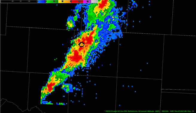
Fig. 1: Reflectivity At Lowest Altitude (RALA) ring over the KMAF radar (Midland/Odessa, TX) at
0506 UTC on 08 May 2014.
Quality Control
This product is derived from the 3D Reflectivity Cube, which means non-hydrometeorological data has been removed including: Ground clutter, anomalous propagation (AP), chaff, interference spikes, and bioscatterers (e.g., angels and ghosts). However, bright band contamination (i.e., anomalously-high reflectivity caused by melting snowflakes) remains.
Applications
Provides a “best guess” of precipitation intensity near the ground.
Enhances low-level storm interrogation and triage for storms covering large regional extents (e.g., MCS).
Example Images
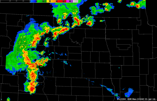
Fig. 2: Reflectivity at Lowest Altitude (RALA) for a MCS over North Dakota and Minnesota at 2204Z on
21 July 2014.