Multi-Sensor QPE - Warning Decision Training Division (WDTD)
Navigation Links
Products Guide
Multi-Sensor QPE
Short Description
Multi-Sensor QPE supplements radar data with combination of gauges and NWP QPF (HRRR/RAP blend for CONUS) to gap-fill in poor radar coverage areas. The Multi-Sensor QPE is available in two products: Pass 1 and Pass 2. Pass 1 is available first, but with less gauges included. Pass 2 has a higher latency, but with most gauges included.
Subproducts
1-, 3-, 6-, 12-, 24-, 48-, and 72-hour accumulations
- Multi-Sensor QPE Pass 1 -- less latency, but less gauges
- Multi-Sensor QPE Pass 2 -- more latency, but more gauges
Primary Users
NWS: WFO, RFC
Input Sources
Radar QPE w/ Gauge Bias Correction, Mountain Mapper QPE
NWP model QPF (varies based on domain)
HADS, MADIS, RR5HFO gauge networks
Resolution
Spatial resolution: 1km x 1km
Temporal resolution: Updated hourly at the top of the hour. All products end at the indicated time.
- Multi-Sensor QPE Pass 1 -- 20-min latency,10% of gauges included
- Multi-Sensor QPE Pass 2 -- 60-min latency, 60% of gauges included
Product Creation
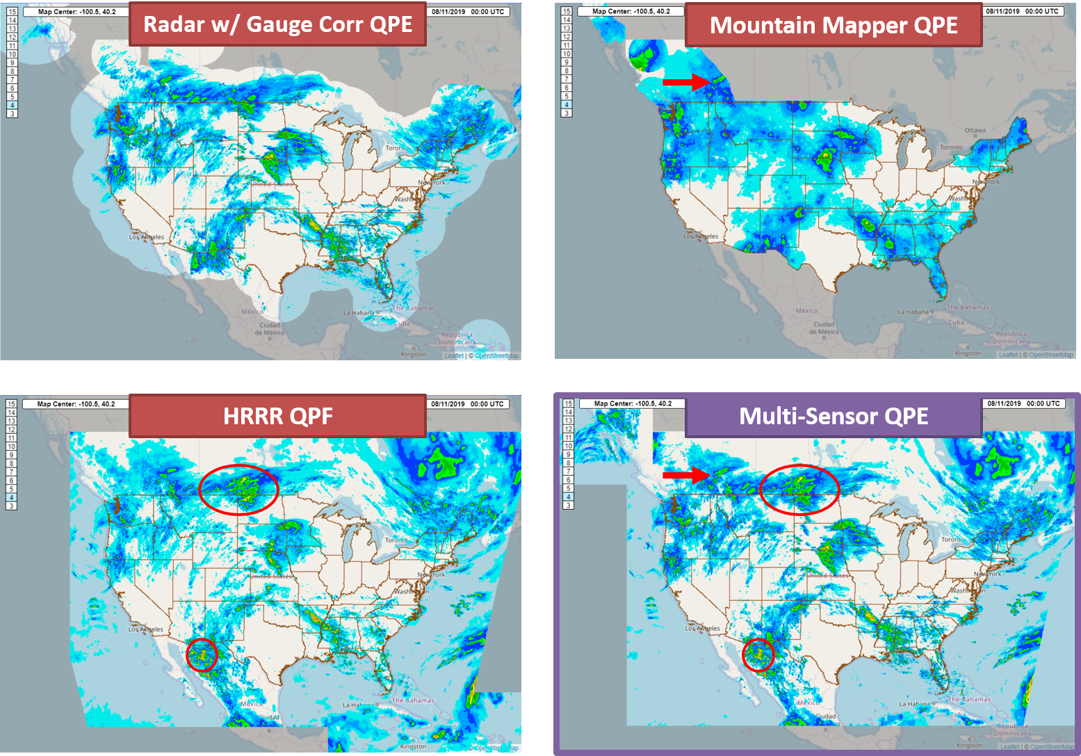
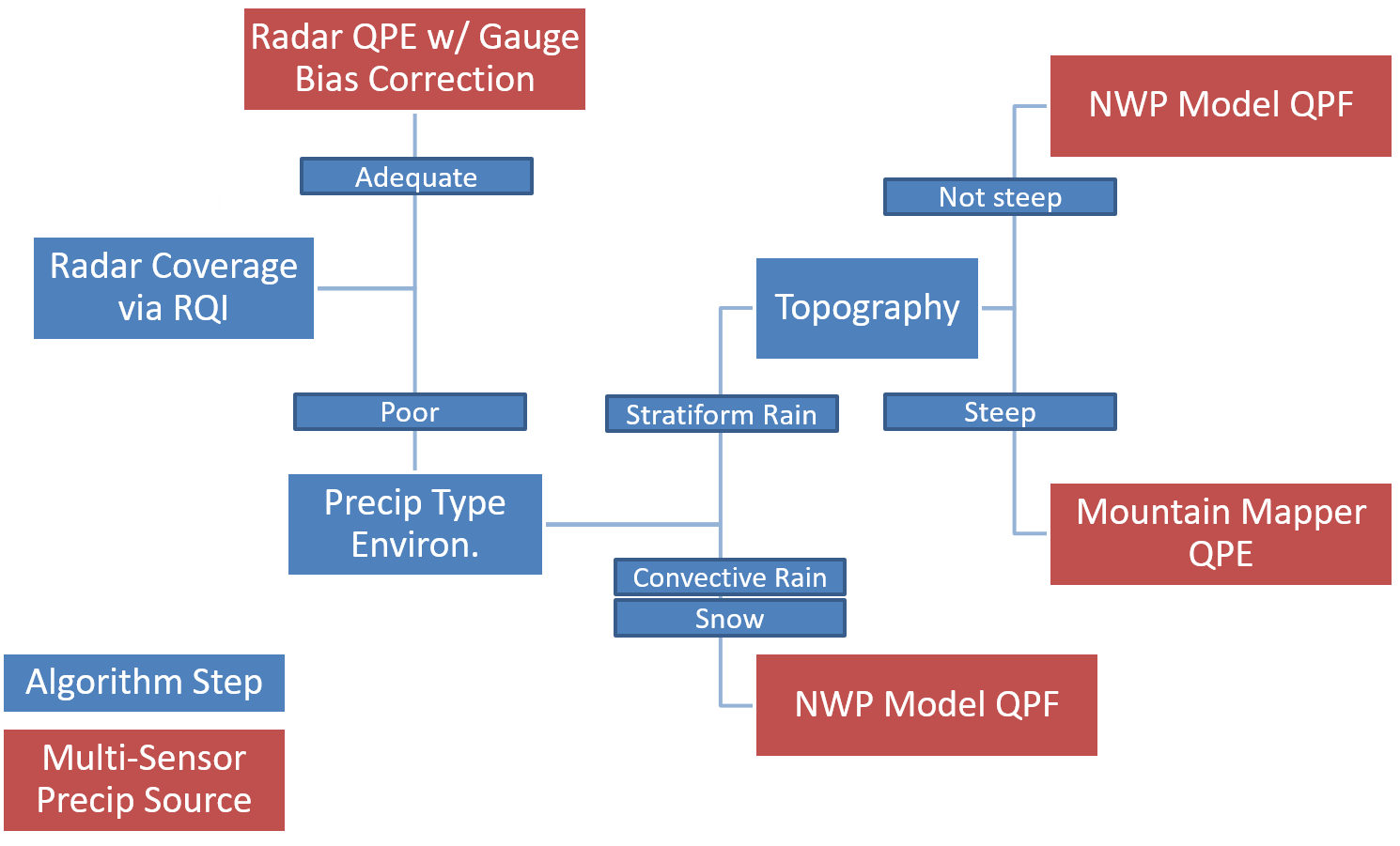
The Multi-Sensor QPE is based on a decision tree that determines which input product shall be assigned at each grid cell: Radar QPE w/ Gauge Bias Correction, Mountain Mapper QPE, or NWP model QPF. These decisions are based on radar coverage (via RQI), the precip type environment, and topography. The preferred input is the Radar QPE w/ Gauge Bias Correction, with the other two inputs supplementing in areas where radar coverage is poor.
Technical Details
Latest Update: MRMS Version 12.2
Description of flow chart below
There are significant radar coverage gaps across the western CONUS and in other MRMS domains (e.g., Alaska). To supplement the radar data, the new Multi-Sensor QPE utilizes a combination of gauges (via Mountain Mapper QPE) and NWP (HRRR/RAP blend for CONUS) to gap-fill in poor radar coverage areas.
- The logic uses the Radar QPE w/ Gauge Bias Correction as the primary precipitation source with its weight in the scheme defined by the RQI product.
- Beyond the areas using radar coverage, the combination of Mountain Mapper and NWP are dependent on a number of variables.
- NWP (via the 1-h forecast QPF) is utilized in snow environments and also in stratiform rain environments over areas of non-complex terrain.
- Mountain Mapper QPE is utilized in areas of stratiform rain over areas of complex terrain.
- Each source is seamlessly blended to avoid any discontinuities in the data.
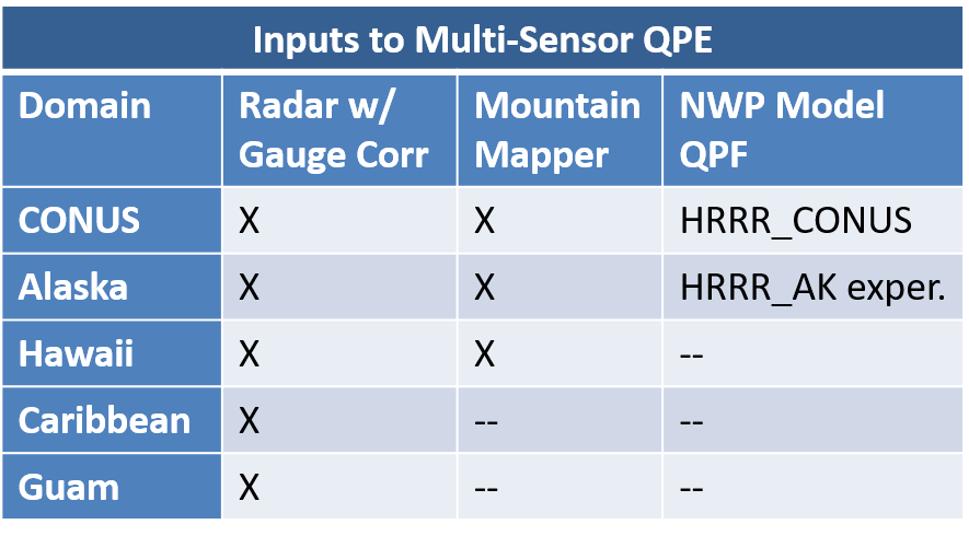
Multi-Sensor Inputs
Below are the inputs used in the Multi-Sensor QPE products, as of V12.2:
References
Martinaitis, S. M., Cocks, S. B., Simpson, M. J., Osborne, A. P., Harkema, S. S., Grams, H. M., ... & Howard, K. W. (2021). Advancements and Characteristics of Gauge Ingest and Quality Control within the Multi-Radar Multi-Sensor System. Journal of Hydrometeorology, 22(9), 2455-2474. https://doi.org/10.1175/JHM-D-20-0234.1
Martinaitis, S. M., Osborne, A. P., Simpson, M. J., Zhang, J., Howard, K. W., Cocks, S. B., ... & Kaney, B. T. (2020). A physically based multisensor quantitative precipitation estimation approach for gap-filling radar coverage. Journal of Hydrometeorology, 21(7), 1485-1511. https://doi.org/10.1175/JHM-D-19-0264.1.
Qi, Y., S. Martinaitis, J. Zhang, and S. Cocks, 2016: A real-time automated quality control of hourly rain gauge data based on multiple sensors in MRMS system. J. Hydrometeor., 17, 1675–1691.
Applications
Due to its latencies, the Multi-Sensor QPE products are not as useful during flash flood warning operations. However, they can be used to:
- Update rainfall totals in Flash Flood Statements
- Compare with previous hours' Radar Only QPE to get a sense or real-time biases in the Radar-Only product
- To validate rainfall totals
- For input to hydrological models
- For flood forecasting
Example Images