Reflectivity at x°C - Warning Decision Training Division (WDTD)
Navigation Links
- 2D Reflectivity Mosaics
- 3D Derived Reflectivity Mosaics
- 3D Reflectivity Mosaics
- FLASH Products
- Lightning
- Most Useful Products
- Operational MRMS Hydro Products
- Precipitation Quality Control
- Severe Weather
- Reflectivity At Lowest Altitude (RALA)
- Reflectivity at x°C
- Probability of Severe Hail (POSH)
- Severe Hail Index (SHI)
- Vertically Integrated Liquid (VIL)
- VIL Density
- xx dBZ Echo Top (ET)
- MESH Tracks
- Rotation Tracks
- Maximum Estimated Size of Hail (MESH)
- Vertically Integrated Ice (VII)
- Height of xx dBZ Echo Above x°C
- Azimuthal Shear
- ProbSevere
- Supplementary MRMS Hydro Products (not on AWIPS)
- Useful Products for Aviation
- Composite Reflectivity Track 60min
- Layer Composite Reflectivity
- Composite Reflectivity
- Composite Reflectivity Height
- Lightning Probability
- Lightning Density
- MESH Tracks
- Maximum Estimated Size of Hail (MESH)
- Rotation Tracks
- Azimuthal Shear
- VIL Density
- xx dBZ Echo Top (ET)
- Vertically Integrated Ice (VII)
- Vertically Integrated Liquid (VIL)
Products Guide
Reflectivity at x°C
Short Description
The reflectivity on a constant temperature surface.
Subproducts
Reflectivity at 0°C
Reflectivity at -5°C
Reflectivity at -10°C
Reflectivity at -15°C
Reflectivity at -20°C
Primary Users
NWS: WFO, CWSU, AWC
Input Sources
3D Reflectivity Cube
Vertical temperature profile from the current operational NCEP/EMC mesoscale model (i.e., the RAP as of 2015).
Resolution
Spatial Resolution: 0.01o Latitude (~1.11 km) x 0.01o Longitude (~1.01 km at 25oN and 0.73 km at 49oN)
Temporal Resolution: 2 minutes
Product Creation
Isothermal reflectivity products are computed by finding the reflectivity at an altitude corresponding to a certain temperature value (0°C, -5°C, -10°C, -15°C, or -20°C) that was obtained from an analysis of the near-storm environment by a mesoscale model.
At each horizontal 2D grid point, the altitude of the particular temperature value (e.g., 0°C) is checked from the top-down. Once the temperature value becomes greater than the temperature being searched for, the altitude is computed by interpolating between the current level and the previous higher level. This calculation method accounts for low-level inversions in the temperature profile by specifically targeting altitudes that are associated with deep convection (e.g., elevated convection over shallow cold layers).
The isothermal reflectivity at that temperature altitude is then computed by interpolating the reflectivity between the two vertically adjacent grid points.
Technical Details
Latest Update: MRMS Version 10
References
None
Strengths
Like all MRMS products, the use of multiple radars is more robust than single-site radar alone. It provides faster updates and helps the forecaster integrate data from multiple radars. It also compensates for cone-of-silence, beam broadening at far ranges, and terrain blockage.
The use of mesoscale model analysis data to derive temperature information allows the temperature fields to vary across the domain of interest. This is in stark contrast to applying a single temperature altitude proxy across the entire domain, as is often done for single radar calculations. Thus, MRMS data better captures gradients in the temperature fields over space and time.
Limitations
Subject to the biases and deficiencies of the mesoscale model used to derive the vertical temperature profile.
Quality Control
This product is derived from the 3D Reflectivity Cube, which means non-hydrometeorological data has been removed including: Ground clutter, anomalous propagation (AP), chaff, interference spikes, and bioscatterers (e.g., angels and ghosts).
Applications
Can be used to assess a storm’s severe potential. For example, the presence of reflectivities greater than 50 dBZ near the -20°C isotherm can indicate the potential for hail.
Isothermal reflectivity in the 0°C to -20°C range can be used to infer supercooled large drops (SLD) associated with severe aircraft icing.
Example Images
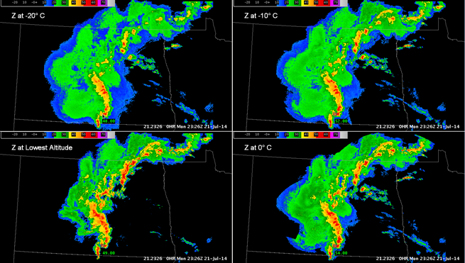
Fig. 1: Isothermal reflectivity at -20°C, -10°C, and 0°C and Reflectivity At Lowest Altitude (RALA) for
a MCS over North Dakota at 2326Z on 21 July 2014. Several areas within the MCS exhibit reflectivity
values > 50 dBZ in the -20°C to 0°C layer, indicating pockets of stronger updrafts. These localized
regions are ill-defined in the RALA, with reflectivities > 50 dBZ spread over a much broader area.