


Maximum Streamflow - Warning Decision Training Division (WDTD)
Navigation Links
Products Guide
Maximum Streamflow
Short Description
The maximum surface water flow that has occurred at every grid point from a period of 30 minutes prior to model runtime out to 12 hours after model runtime
Subproducts
CREST, SAC-SMA, and Hydrophobic. The FLASH EF5 framework runs multiple hydrological models using a common input. For MRMS Version 12, there is a maximum streamflow product for each of the 3 models listed here.
Primary Users
NWS: WFO, RFC
Input Sources
MRMS Radar-Only QPE
Resolution
Spatial: ~1 km x 1 km
Temporal: 10 minutes
Product Creation
The FLASH EF5 model framework uses MRMS Radar-Only QPE as input into the 3 hydrological models (CREST, SAC-SMA, and Hydrophobic) which then use a subset of these hydrological principles (infiltration, storage, interflow, evapotranspiration, and runoff) to route the precipitation through the basins. The maximum water flow that occurs at any time in each grid point during the model run from a period of 30 minutes prior to model runtime through 12 hours after model runtime is assigned to each grid point.
Technical Details
Latest Update: MRMS Version 12
NOTE: In version 12, all FLASH products now use the instantaneous rainfall rates from the Dual-pol radar synthetic QPE product.
Accessible on:
- Operational AWIPS
- V11.5 -- MRMS menu
- V12 -- via LDM, if set-up
- MRMS Development site
References
Gourley, J., Z. Flamig, H. Vergara, P. Kirstetter, R. Clark III, E. Argyle, A. Arthur, S. Martinaitis, G. Terti, J. Erlingis, Y. Hong, and K. Howard, 2016: The Flooded Locations And Simulated Hydrographs (FLASH) project: improving the tools for flash flood monitoring and prediction across the United States. Bull. Amer. Meteor. Soc. doi:10.1175/BAMS-D-15-00247.1, in press.
Jiahu Wang , Yang Hong , Li Li , Jonathan J. Gourley , Sadiq I. Khan , Koray K. Yilmaz , Robert F. Adler , Frederick S. Policelli , Shahid Habib , Daniel Irwn , Ashutosh S. Limaye , Tesfaye Korme & Lawrence Okello (2011) The coupled routing and excess storage (CREST) distributed hydrological model, Hydrological Sciences Journal, 56:1, 84-98, DOI: 10.1080/02626667.2010.543087
Applications
Visualize major streams and river networks to identify broad areas of high flow
Compare with USGS gauging sites (but keep context in mind)
Identify model biases which could affect Maximum Unit Streamflow
Example Images
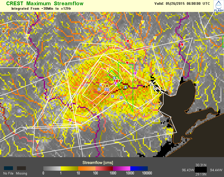
Figure 1. Notice how over the Houston metro area (center part of graphic) there are broad flows of up to 10 m3/s (350 cfs). This shows how the CREST model is capable of producing overland flows because so much rain had fallen over this urban area, that the infiltration rates could not keep up and prevent overland runoff conditions.