Legacy Base Reflectivity - Warning Decision Training Division (WDTD)
Navigation Links
- 2D Reflectivity Mosaics
- 3D Derived Reflectivity Mosaics
- 3D Reflectivity Mosaics
- FLASH Products
- Lightning
- Most Useful Products
- Operational MRMS Hydro Products
- Precipitation Quality Control
- Severe Weather
- Reflectivity At Lowest Altitude (RALA)
- Reflectivity at x°C
- Probability of Severe Hail (POSH)
- Severe Hail Index (SHI)
- Vertically Integrated Liquid (VIL)
- VIL Density
- xx dBZ Echo Top (ET)
- MESH Tracks
- Rotation Tracks
- Maximum Estimated Size of Hail (MESH)
- Vertically Integrated Ice (VII)
- Height of xx dBZ Echo Above x°C
- Azimuthal Shear
- ProbSevere
- Supplementary MRMS Hydro Products (not on AWIPS)
- Useful Products for Aviation
- Composite Reflectivity Track 60min
- Layer Composite Reflectivity
- Composite Reflectivity
- Composite Reflectivity Height
- Lightning Probability
- Lightning Density
- MESH Tracks
- Maximum Estimated Size of Hail (MESH)
- Rotation Tracks
- Azimuthal Shear
- VIL Density
- xx dBZ Echo Top (ET)
- Vertically Integrated Ice (VII)
- Vertically Integrated Liquid (VIL)
Products Guide
Legacy Base Reflectivity
Short Description
A 2D mosaic of quality controlled base reflectivity observations from the lowest tilts of all radars.
Subproducts
None
Primary Users
NWS: WFO, CWSU, RFC, AWC, SPC, WPC
Input Sources
WSR-88D Radars
Resolution
Spatial Resolution: 0.01o Latitude (~1.11 km) x 0.01o Longitude (~1.01 km at 25oN and 0.73 km at 49oN)
Temporal Resolution: 2 minutes
Product Creation
The product is generated via a 2D mosaicking of one tilt (the lowest) of base reflectivity from all radars.
Technical Details
Latest Update: MRMS Version 10
References
None
Strengths
Like all MRMS products, the use of multiple radars is more robust than single-site radar alone. It provides faster updates and helps the forecaster integrate data from multiple radars. It also compensates for cone-of-silence, beam broadening at far ranges, and terrain blockage.
Limitations
Bright band contamination is not removed.
Spatial resolution of 1 km x 1 km is not as good as super-resolution data from nearby single-site radar.
Quality Control
Quality controlled to remove non-meteorological echoes.
Applications
Provides a “best guess” of precipitation intensity near the ground.
Enhances low-level storm interrogation and triage for storms covering large regional extents (e.g., MCS).
Example Images
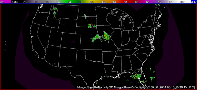
Fig. 1: Legacy Base Reflectivity at 1626 UTC on 15 August 2014.