Since you only need a few granules per day and you want to retain
full SNAP compatibility, our online tools can be used to obtain the data.
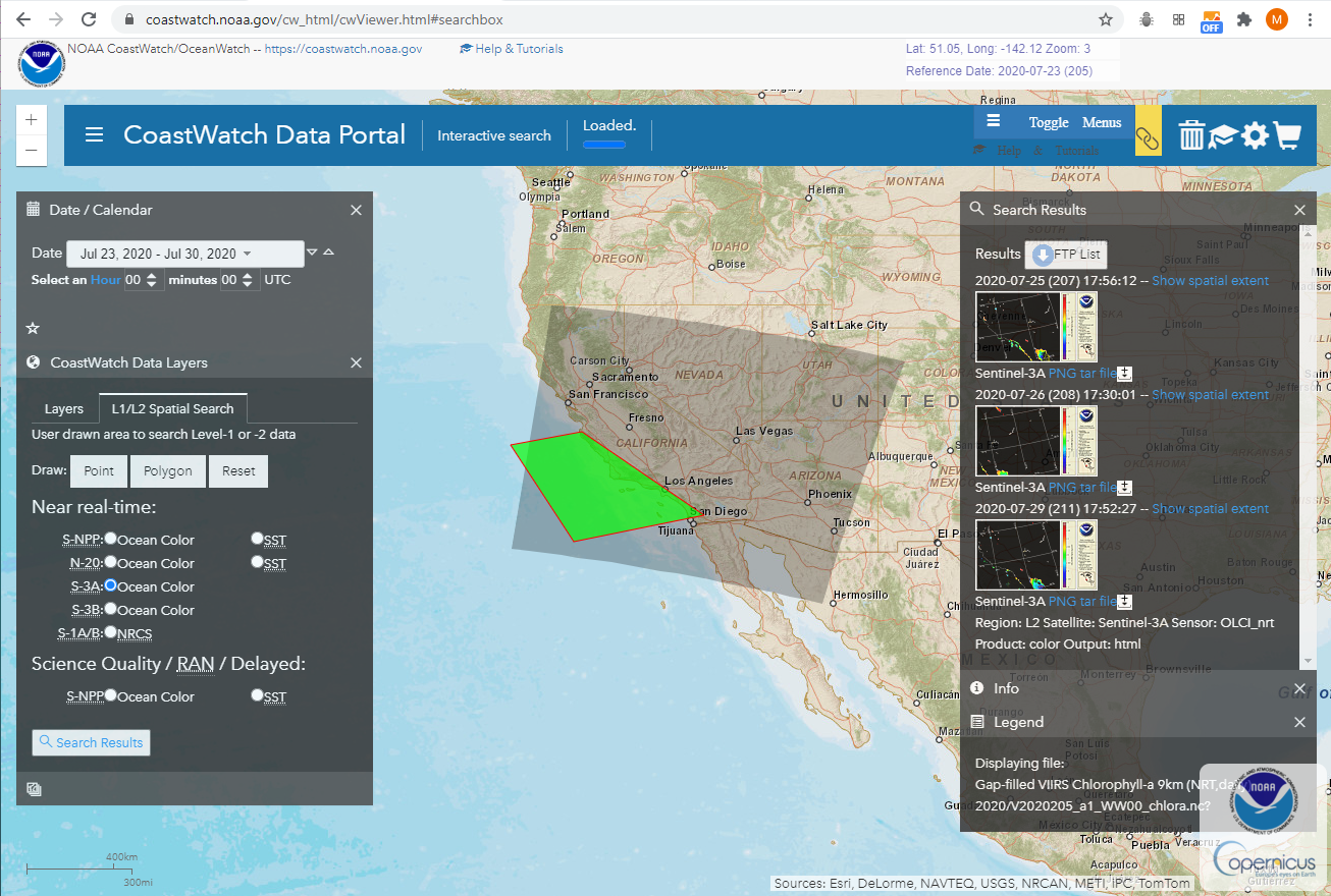
Using the Data
Portal, I drew a green polygon as my ROI and then performed a
search for S-3A data for the past week. Results are displayed on the
right under the results panel. From there I can preview the data to
decide if coverage and visibility are adequate and then either add to
a download list or complete my search by using the shopping cart to
download a list of URLs to the selected datasets or initiate a search
for S-3B granules for additional coverage.
[Image below shows the green ROI and the footprint of an OLCI granule]
If this needs to be automated, you can use the following URL to
obtain a list of the data programmatically:
where the POLYGON, satellite, and date ranges can be modified.
Results would be the list of:
ftp://ftp.star.nesdis.noaa.gov/pub//socd3/coastwatch/olci/L2/2020/207/S3A_OL_2_WFR____20200725T175612_20200725T175912_20200725T195613_0179_061_041_2340_MAR_O_NR_002.SEN3.tar
ftp://ftp.star.nesdis.noaa.gov/pub//socd3/coastwatch/olci/L2/2020/208/S3A_OL_2_WFR____20200726T173001_20200726T173301_20200726T192800_0179_061_055_2340_MAR_O_NR_002.SEN3.tar
ftp://ftp.star.nesdis.noaa.gov/pub//socd3/coastwatch/olci/L2/2020/211/S3A_OL_2_WFR____20200729T175227_20200729T175527_20200729T195543_0179_061_098_2340_MAR_O_NR_002.SEN3.tar
The tar files will extract to the SEN3 directory where SNAP can be
used to open the xfdumanifest.xml for working with the data.
If you desire mapped products from CoastWatch (compatible with
CoastWatch software), there are additional
access methods that can be used including THREDDS services as
described on the OLCI page. Sectors are full resolution (300m) mapped
to geographic/WGS84 however for your area of interest, you may need 2
sectors to complete coverage [see image below -- Sectors 'CI' and 'DI'
are the two tiles that encompass the ROI].
Copernicus Mission data is provided by EUMETSAT.
