


RE: Re: GFS FV3 #2 in August - EMC Model Evaluation Group
EMC's Model Evaluation Group
The Model Evaluation Group (MEG) community is established to interact with the user community on issues related to the forecast systems of NCEP's Environmental Modeling Center (EMC). It is used to discuss overall model performance and provide feedback on operational and parallel versions of the models which comprise the production suite.
Forums
Navigation Menu
What's New
GM
Geoffrey Manikin, modified 6 Years ago.
RE: Re: GFS FV3 #2 in August
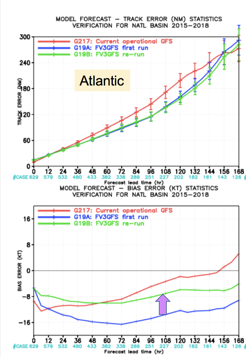
Youngling Posts: 11 Join Date: 8/25/15 Thanks for your post. I'm attaching an image from
the MEG tropical recap presentation given a few weeks ago. The
top panel is track error, and the bottom panel is intensity bias -
both for the Atlantic basin covering the past 3 hurricane seasons.
The red is the ops GFS, the blue is the original FV3GFS
configuration, and the green is the final configuration. (A
science change was made in early August to address the significant
low intensity bias in tropical cyclones).
It's clear that both the initial and final FV3GFS
improve the track, relative to the ops GFS. The original FV3GFS
configuration clearly had a significant weak intensity bias. It's
mitigated in the final configuration (change shown by the purple
arrow), but beyond day 2, the FV3GFS still has a low intensity bias
relative to the GFS. So your hunch that the FV3GFS is underdoing
the intensity of Florence may be very much on the right track.
That said, even though the composite stats don't reflect it, the GFS
is prone to going crazy with the central pressure in the strongest
storms (i.e. the sub 900 pressures in 2017 Irma forecasts and
perhaps in some Florence runs).
-Geoff
On Mon, Sep 10, 2018 at 9:44 PM, Warren
Blier <VLab.Notifications@noaa.gov> wrote:
Jeff,Great to see! Interesting to note dramatic difference between GFS and FV3 re both intensity and path of Florence as it approaches the Carolinas (see attached figs). We'll see. I'm attaching the corresponding ECMWF output for comparison. Personal hunch is that FV3 is way-underdoing the intensity but may be better (than the GFS) on the longer-term path.Warren--------------------------Warren Blier, Ph.D.Science and Operations OfficerNational Weather ServiceSan Francisco Bay Area/Monterey Forecast Office21 Grace Hopper Ave, Stop 5Monterey, CA 93943-5505831-656-1710 x224 or 831-656-1724
On Mon, Sep 10, 2018 at 4:49 PM, Jeffrey Craven - NOAA Federal <0000008037b22bcd-dmarc-request@listserv.albany.edu> wrote:
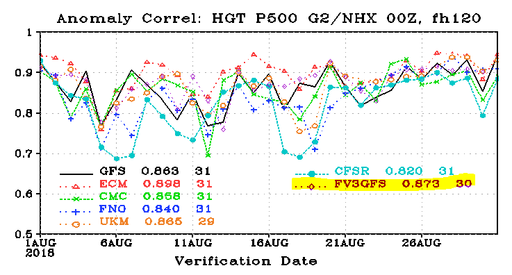
I know we have more important things to worry about with Florence.But I don't want this to get lost....It is early, but August 2018 500mb Height AC scores would put GFS FV3 as second best.Definitely moving in the right direction! Hopefully this trend will continue.JPC Jeff CravenChief, Statistical Modeling BranchNational Weather Service, W/STI-12Meteorological Development Laboratory (MDL)Room 10410, SSMC2Silver Spring, MD 20910(301) 427-9475 office(816) 506-9783 cell/text@jpcstorm
To unsubscribe from the MAP list, click the following link and send the email generated:
MAP-SIGNOFF-REQUEST@LISTSERV.ALBANY.EDU
--
Warren Blier EMC Model Evaluation Group Virtual Lab Forum http://vlab.noaa.gov/web/emc-model-evaluation-group/home/-/message_boards/view_message/4821411VLab.Notifications@noaa.gov
- Modified Date
- 9/11/18
GM
Geoffrey Manikin
6 Years Ago
More Details