Convective/Stratiform Precipitation Separation (CSPS) Algorithm - Warning Decision Training Division (WDTD)
Navigation Links
Products Guide
Convective/Stratiform Precipitation Separation (CSPS) Algorithm
Short Description
An algorithm which classifies single site radar reflectivity data as either convective or stratiform.
Subproducts
None.
Primary Users
None. This algorithm is not a MRMS product, but rather solely incorporated into other algorithms and products.
Input Sources
Radar Reflectivity, Radar Blockage Maps, NOAA/NCEP Rapid Refresh (RAP) with nested High-Resolution Rapid Refresh (HRRR) environmental data, Vertically Integrated Liquid (VIL)
Resolution
Spatial Resolution: 1km x 1km
Temporal Resolution: 2 minutes
Product Creation
The Convective/Stratiform Precipitation Separation (CSPS) algorithm classifies single site radar reflectivity data as either convective or stratiform. The purpose of the convective/stratiform identification is to aid in adjusting reflectivity values in the melting layer, where mixed-phase hydrometeors can cause higher reflectivities and overestimates in rain rates that assume liquid drop distributions. It is completed via three main steps:
- Checking the hourly RAP Freezing Level Height
- Identifying convective cores via decision tree logic dependent on range from radar, 3D reflectivity structure, Vertically Integrated Liquid, and RAP environmental temperature data
- Determining the areal extent of convective precipitation by considering surrounding pixels.
Technical Details
CSPS consists of three key steps:
- Check the hourly RAP Freezing Level Height (FLH). Low FLHs mean low bright band areas, which can create artificially high reflectivity values at low levels. If you begin the separation algorithm with just a reflectivity threshold, stratiform regions with low FLHs may be misclassified as convective.
- If the FLH < 2 km, the cell is deemed stratiform.
- Identify convective cores via decision tree logic dependent upon range from radar, 3D reflectivity structure, Vertically Integrated Liquid (VIL) and environmental temperature data (see Figure 1).
- Divide the radar domain into three areas based on range: 0-25 km, 25-250km, and beyond 250 km. This helps account for beam broadening and vertical radar coverage expansion effects with range.
- 0-25 km: if max reflectivity below 1.3 km is > 45 dBZ, it is convective.
- 25-250 km:
- If VIL < 6.5 kg/m2….stratiform.
- If VIL ≥ 6.5 kg/m2, check the reflectivity at the -10°C level.
- If -10°C reflectivity < 30 dBZ….stratiform.
- If -10°C reflectivity ≥ 30 dBZ and reflectivity at 0°C level < 45 dBZ...convective.
- If reflectivity at 0°C level ≥ 45 dBZ, then look again at the -10°C reflectivity. If it is < 30 dBZ...stratiform.
- If reflectivity at 0°C level ≥ 45 dBZ, then look again at the -10°C reflectivity. If it is ≥ 30 dBZ...convective.
- Beyond 250 km: if the reflectivity at the -10°C level is ≥ 35 dBZ, then it is convective.
- Any pixel found to be a convective core is then run through a neighborhood check to make sure they are not spurious. If 6 surrounding pixels (within a defined box) were also labeled convective, then this pixel is found to be “robust”.
- Divide the radar domain into three areas based on range: 0-25 km, 25-250km, and beyond 250 km. This helps account for beam broadening and vertical radar coverage expansion effects with range.
- Determine the areal extent of convective precipitation via a specialized routine known as a seeded region-growing algorithm.
- At each “convective core”, look at the immediate pixels bordering it (8 pixels). At each one of those 8 pixels, look at their surrounding 8 pixels. If the composite reflectivity (at any surrounding pixel) is > 35 dBZ, then label that pixel “convective”, and add its surrounding pixels to the domain to be considered. Otherwise, label it “stratiform” and leave out the surrounding pixels.
- Repeat this process until the threshold is not met.
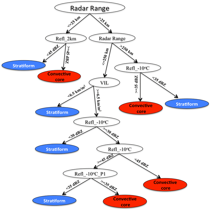
Figure 1. Decision tree schematic illustrating the logic used to determine if a reflectivity bin is classified as “convective” or “stratiform.”
References
Qi, Youcun, Jian Zhang, and Pengfei Zhang. "A real‐time automated convective and stratiform precipitation segregation algorithm in native radar coordinates." Quarterly Journal of the Royal Meteorological Society 139.677 (2013): 2233-2240.
Tilt Apparent Vertical Profile of Reflectivity Correction Algorithm documentation
Other MRMS product documentation: Polar VPR, Seamless Hybrid Scan Reflectivity, Surface Precipitation Type
Applications
Once properly classified, the reflectivity data is ready for bright band contamination removal by the Tilt Apparent Vertical Profile of Reflectivity (Tilt AVPR) Correction algorithm. Output is also used by the Polar VPR, Seamless Hybrid Scan Reflectivity, and Surface Precipitation Type products. The SHSR and SPT define the Surface Precipitation Rate product.
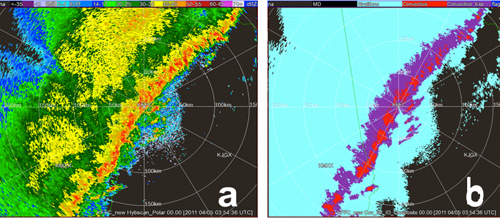
Example Images