Seamless Hybrid Scan Reflectivity (SHSR) - Warning Decision Training Division (WDTD)
Navigation Links
Products Guide
Seamless Hybrid Scan Reflectivity (SHSR)
Short Description
Quality-controlled reflectivity at the lowest possible vertical level. SHSR is used as an input to calculate Surface Precipitation Rates. It is available only via the NWS LDM or the MRMS Operational Product Viewer as of MRMS v12.2.
Subproducts
None.
Primary Users
NWS: WFO, RFC
Input Sources
Radar Reflectivity, Radar Blockage Maps
Resolution
Spatial resolution: 1km x 1km
Temporal resolution: 2 minutes
Product Creation
The Seamless Hybrid Scan Reflectivity (SHSR) product is a quality-controlled reflectivity product that is first derived from single radar polar grids, and then mosaicked onto the MRMS national Cartesian grid. The steps are summarized as follows:
- Complete the steps required in the Dual Polarization Quality Control in order to remove non-precipitation echoes from the reflectivity grid.
- Complete a power compensation adjustment to bins that have partial beam blockage, in order for the reflectivity in that bin to be best represented.
- Classify the reflectivity as either convective or stratiform using the Convective/Stratiform Precipitation Separation (CSPS) algorithm.
- Adjust reflectivity within and above the bright band using the Tilt Apparent Vertical Profile of Reflectivity (AVPR) correction.
- Using the AVPR-corrected reflectivities from a single radar, construct a 2-D polar grid hybrid scan reflectivity (HSR).
- Apply non-standard beam blockage mitigation (e.g. trees, manmade buildings) to the HSR field to obtain the single-radar “seamless” HSR (SHSR) field.
- Create the SHSR mosaic by using a distance-weighted mean scheme, described in the QPE Mosaic Process documentations, that alleviates previous problems with over- and under-estimation related to averaging rain and ice regions.
Technical Details
NOTE: For the latest technical details as of MRMS Version 12.2, please see this document.
Many areas in the MRMS domain are covered by multiple radars. An ideal method to get the most accurate precipitation rate estimate at the ground is to take data from the lowest radar bin, among multiple radars, that is not significantly blocked. For beams that are blocked by more than 50%, the next elevation angle is used. Those bins constitute a 2-D polar grid called “hybrid scan” reflectivity (HSR; Fulton et al. 1998). However, this method produces discontinuities between neighboring radars due to different radar wave propagation, calibration biases, etc. To mitigate these discontinuities, the “seamless” hybrid scan was developed that uses a weighted mean of reflectivities for bins that have 10-50% blockage. The process to create the SHSR is described below:
- Complete the steps required in the Dual Polarization Quality Control (dpQC) in order to remove non-precipitation echoes from the reflectivity grid.
- Some beams will have partial beam blockage that is less than 50%. These will require a power compensation to be applied to them, in order to have more representative reflectivity values. This is always a positive contribution, to add back in blocked reflectivity.
- The reflectivity in these bins are adjusted such that:
Zadj = Zobs/β
where Zobsis the reflectivity before compensation, Zadj is the reflectivity after compensation, and β is the two-way power loss due to the beam blockages. β is computed using the process described in Doviak and Zrnic (1993)
- The reflectivity in these bins are adjusted such that:
- Classify the reflectivity as either convective or stratiform using the Convective/Stratiform Precipitation Separation (CSPS) algorithm.
- Adjust reflectivity within and above the bright band using the Tilt Apparent Vertical Profile of Reflectivity (AVPR) correction.
- Using the AVPR-corrected reflectivities from a single radar, construct a 2-D polar grid hybrid scan reflectivity (HSR).
- A bin is only considered if it is blocked by less than 50% and the bottom of the bin clears the ground by at least 50 m. Otherwise, data from the next tilt up is used.
- Apply non-standard beam blockage mitigation (NSBM; Tang et al. 2013) to the HSR field to obtain the single-radar “seamless” HSR field.
- QPE accumulation fields may still have non-standard beam blockage issues (e.g. man-made towers, trees) that are not accounted for in DEMs. The bounds of the gaps (in azimuth and range) are manually calculated, and different interpolation methods are used based on the size of the gaps.
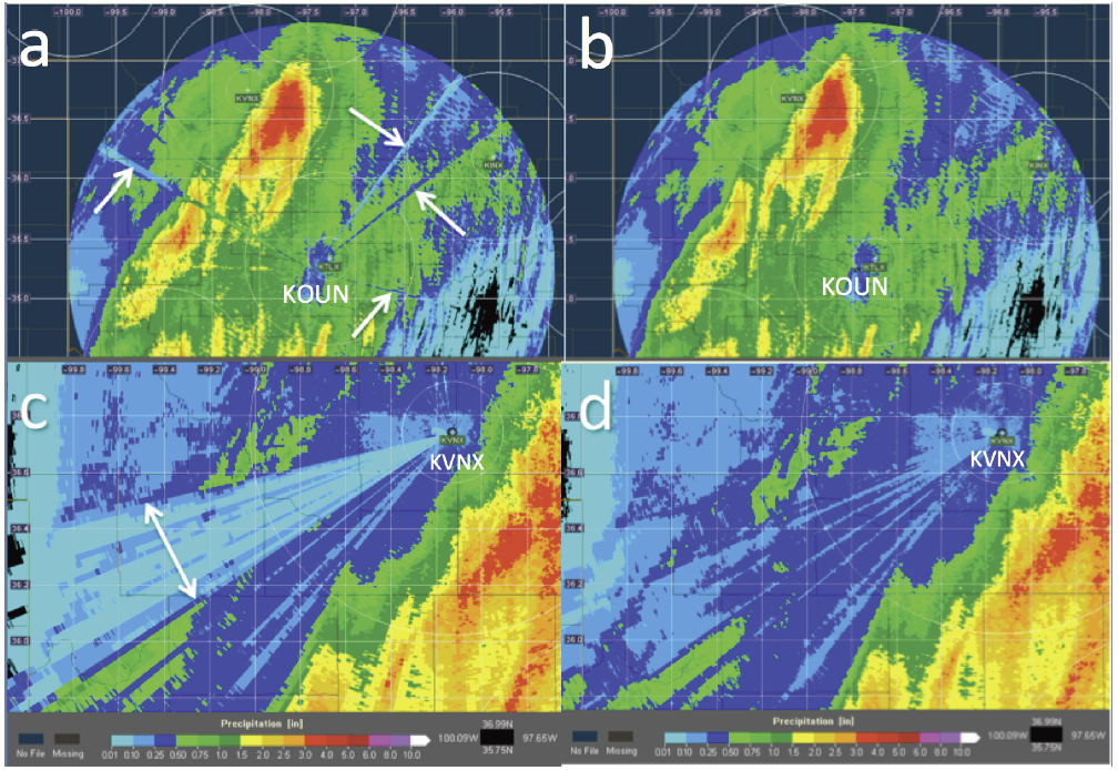
- Small/Narrow gaps are linearly interpolated using cross-azimuth values (i.e. same elevation, looking on either side of the gap). An example of the small gap interpolation is shown in Figure 1a and 1b.
- Large/Wide gaps are filled with the values of the next upward elevation scan that is unblocked (Figure 1c and 1d).
- QPE accumulation fields may still have non-standard beam blockage issues (e.g. man-made towers, trees) that are not accounted for in DEMs. The bounds of the gaps (in azimuth and range) are manually calculated, and different interpolation methods are used based on the size of the gaps.
- The resulting field is the “seamless” HSR for a single radar.
- Create the SHSR mosaic by using a distance-weighted mean scheme that alleviates previous problems with over- and under-estimation related to averaging rain and ice regions (see QPE Mosaic Process). Figure 2 is an example SHSR mosaic product.
References
Hanft et al. 2022: Dual-pol VPR corrections for improved operational radar QPE in MRMS. In preparation for submission to the J. Hydromet.
Zhang, J., K. Howard, S. Vasiloff, C. Langston, B. Kaney, Y. Qi, L. Tang, H. Grams, D. Kitzmiller, J. Levit, 2014: Initial Operating Capabilities of Quantitative Precipitation Estimation in the Multi-Radar Multi-Sensor System. 28th Conf. on Hydrology, Amer. Meteor. Soc.
Doviak, Richard J., and Dušan S. Zrnić. Doppler radar and weather observations. Courier Dover Publications, 1993.
Zhang, Jian, et al. "Radar-based quantitative precipitation estimation for the cool season in complex terrain: Case studies from the NOAA Hydrometeorology Testbed." Journal of Hydrometeorology 13.6 (2012): 1836-1854.
Fulton, Richard A., et al. "The WSR-88D rainfall algorithm." Weather and Forecasting 13.2 (1998): 377-395.
Tang, L., Y. Qi, C. Langston, K. Howard, 2013: Non-Standard Blockage Mitigation for National Radar QPE Products. The 36th Conf. on Radar Meteorology. Amer. Meteor. Soc. 16–20 Sept. 2013, Breckenridge, CO. Paper 354.
Convective/Stratiform Precipitation Separation algorithm documentation
Dual Polarization Quality Control documentation
Tilt Apparent Vertical Profile of Reflectivity Correction Algorithm documentation
Applications
SHSR is used as an input for calculating the Surface Precipitation Type (SPT) product. Additionally, it is used to calculate Surface Precipitation Rates (SPRs) via Z-R relationships chosen to match the SPT at each grid point. It is also diagnostic when evaluating precipitation estimate errors. SHSR is very similar to the Reflectivity at Lowest Altitude (RALA) product, but the two are computed independently using different quality control processes.
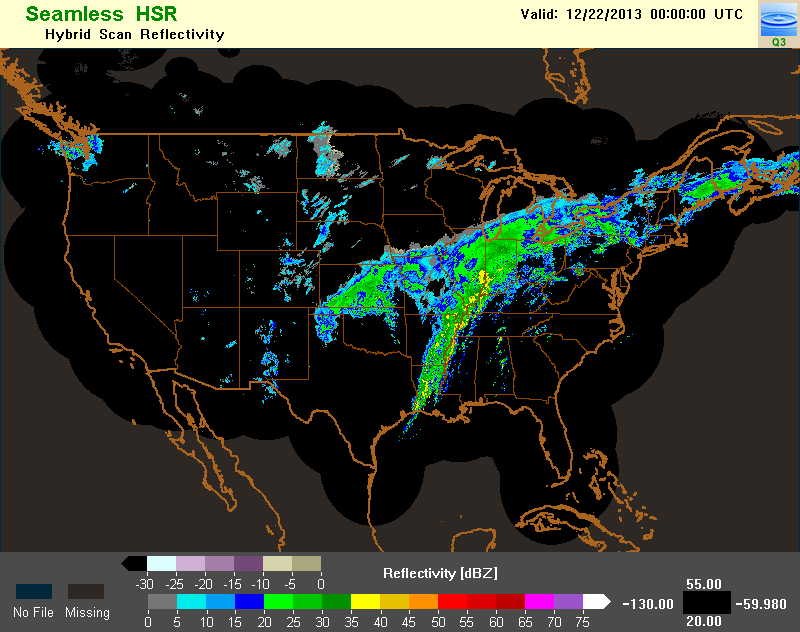
Example Images